Saint-Georges-Montcocq
| Saint-Georges-Montcocq | |
|---|---|
| Commune | |
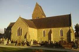 The church in Saint-Georges-Montcocq | |
 Saint-Georges-Montcocq Location within Normandy region  Saint-Georges-Montcocq | |
| Coordinates: 49°07′45″N 1°05′33″W / 49.1292°N 1.0925°WCoordinates: 49°07′45″N 1°05′33″W / 49.1292°N 1.0925°W | |
| Country | France |
| Region | Normandy |
| Department | Manche |
| Arrondissement | Saint-Lô |
| Canton | Pont-Hébert |
| Intercommunality | Saint-loise |
| Government | |
| • Mayor (2008–2014) | Jean-Yves Laurence |
| Area1 | 8.94 km2 (3.45 sq mi) |
| Population (1999)2 | 896 |
| • Density | 100/km2 (260/sq mi) |
| Time zone | UTC+1 (CET) |
| • Summer (DST) | UTC+2 (CEST) |
| INSEE/Postal code | 50475 /50000 |
| Elevation |
7–126 m (23–413 ft) (avg. 90 m or 300 ft) |
|
1 French Land Register data, which excludes lakes, ponds, glaciers > 1 km2 (0.386 sq mi or 247 acres) and river estuaries. 2 Population without double counting: residents of multiple communes (e.g., students and military personnel) only counted once. | |
Saint-Georges-Montcocq is a commune in the Manche department in Normandy in north-western France.
International relations
Saint-Georges-Montcocq is twinned with:
See also
References
- ↑ "British towns twinned with French towns". Archant Community Media Ltd. Retrieved 2013-07-11.
| Wikimedia Commons has media related to Saint-Georges-Montcocq. |
This article is issued from
Wikipedia.
The text is licensed under Creative Commons - Attribution - Sharealike.
Additional terms may apply for the media files.