Courtils
| Courtils | |
|---|---|
| Commune | |
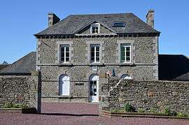 Town hall | |
 Courtils Location within Normandy region  Courtils | |
| Coordinates: 48°37′42″N 1°24′27″W / 48.6283°N 1.4075°WCoordinates: 48°37′42″N 1°24′27″W / 48.6283°N 1.4075°W | |
| Country | France |
| Region | Normandy |
| Department | Manche |
| Arrondissement | Avranches |
| Canton | Pontorson |
| Intercommunality | Avranches - Mont-Saint-Michel |
| Government | |
| • Mayor (2008–2014) | Gérard Chauvois |
| Area1 | 5.39 km2 (2.08 sq mi) |
| Population (2006)2 | 250 |
| • Density | 46/km2 (120/sq mi) |
| Time zone | UTC+1 (CET) |
| • Summer (DST) | UTC+2 (CEST) |
| INSEE/Postal code | 50146 /50220 |
| Elevation |
4–28 m (13–92 ft) (avg. 28 m or 92 ft) |
|
1 French Land Register data, which excludes lakes, ponds, glaciers > 1 km2 (0.386 sq mi or 247 acres) and river estuaries. 2 Population without double counting: residents of multiple communes (e.g., students and military personnel) only counted once. | |
Courtils is a commune in the Manche department in Normandy in north-western France.
See also
| Wikimedia Commons has media related to Courtils. |
| Authority control |
|---|
This article is issued from
Wikipedia.
The text is licensed under Creative Commons - Attribution - Sharealike.
Additional terms may apply for the media files.