Carolles
| Carolles | ||
|---|---|---|
| Commune | ||
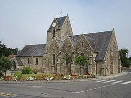 The church of Saint-Vigor | ||
| ||
 Carolles Location within Normandy region  Carolles | ||
| Coordinates: 48°45′05″N 1°33′29″W / 48.7514°N 1.5581°WCoordinates: 48°45′05″N 1°33′29″W / 48.7514°N 1.5581°W | ||
| Country | France | |
| Region | Normandy | |
| Department | Manche | |
| Arrondissement | Avranches | |
| Canton | Avranches | |
| Intercommunality | Communauté de communes de Sartilly - Porte de la Baie | |
| Government | ||
| • Mayor (2008–2014) | René Bagot | |
| Area1 | 3.85 km2 (1.49 sq mi) | |
| Population (2006)2 | 711 | |
| • Density | 180/km2 (480/sq mi) | |
| Time zone | UTC+1 (CET) | |
| • Summer (DST) | UTC+2 (CEST) | |
| INSEE/Postal code | 50102 /50740 | |
| Elevation | 0–77 m (0–253 ft) | |
|
1 French Land Register data, which excludes lakes, ponds, glaciers > 1 km2 (0.386 sq mi or 247 acres) and river estuaries. 2 Population without double counting: residents of multiple communes (e.g., students and military personnel) only counted once. | ||
Carolles is a commune in the Manche department in Normandy in north-western France.
Heraldry
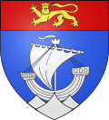 |
The arms of Carolles are blazoned : Azure, a ship equipped on waves argent, on a chief gules a leopard Or. |
See also
External links
| Wikimedia Commons has media related to Carolles. |
Local legends and history of Carolles, the Valley of the Painters and the Lude.
This article is issued from
Wikipedia.
The text is licensed under Creative Commons - Attribution - Sharealike.
Additional terms may apply for the media files.