Beersville, Pennsylvania
| Beersville, Pennsylvania | |
|---|---|
| Unincorporated community | |
 Beersville, Pennsylvania | |
| Coordinates: Coordinates: 40°44′47″N 75°28′15″W / 40.74639°N 75.47083°W | |
| Country | United States |
| State | Pennsylvania |
| County | Northampton |
| Elevation | 525 ft (160 m) |
| Time zone | UTC-5 (Eastern (EST)) |
| • Summer (DST) | UTC-4 (EDT) |
| Area code(s) | 610 and 484 |
| GNIS feature ID | 1169127[1] |
Beersville (also Falmers) is an exurban unincorporated community in southwestern Moore Township, Northampton County, Pennsylvania, United States, on Route 248.[1] It is drained by the Hokendauqua Creek into the Lehigh River and is served by the Northampton Area School District. Despite the name, since the Beersville Hotel burned down in 1985, there has been no place carrying alcoholic beverages in the village.[2] It is split between the Bath and Northampton post offices, which use the zip codes of 18014 and 18067, respectively.[3]
References
- 1 2 "Beersville, Pennsylvania". Geographic Names Information System. United States Geological Survey.
- ↑ "There's no beer to buy in Beersville". Retrieved December 31, 2012.
- ↑ Zip Codes
Municipalities and communities of Northampton County, Pennsylvania, United States | ||
|---|---|---|
| Cities | 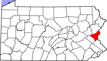 | |
| Boroughs | ||
| Townships | ||
| CDPs | ||
| Unincorporated communities | ||
| Footnotes | ‡This populated place also has portions in an adjacent county or counties | |
Places adjacent to Beersville, Pennsylvania | ||||||||||
|---|---|---|---|---|---|---|---|---|---|---|
| ||||||||||
This article is issued from
Wikipedia.
The text is licensed under Creative Commons - Attribution - Sharealike.
Additional terms may apply for the media files.