Coopersburg, Pennsylvania
| Coopersburg | |
|---|---|
| Borough | |
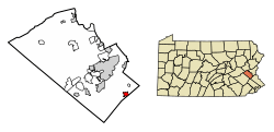 Location of Coopersburg in Lehigh County, Pennsylvania. | |
 Coopersburg Location of Coopersburg in Pennsylvania  Coopersburg Coopersburg (the US) | |
| Coordinates: 40°30′37″N 75°23′24″W / 40.51028°N 75.39000°WCoordinates: 40°30′37″N 75°23′24″W / 40.51028°N 75.39000°W | |
| Country | United States |
| State | Pennsylvania |
| County | Lehigh |
| Government | |
| • Mayor | Gary Hovis |
| Area[1] | |
| • Total | 0.94 sq mi (2.42 km2) |
| • Land | 0.93 sq mi (2.42 km2) |
| • Water | 0.00 sq mi (0.01 km2) |
| Elevation | 545 ft (166 m) |
| Population (2010) | |
| • Total | 2,386 |
| • Estimate (2016)[2] | 2,478 |
| • Density | 2,655.95/sq mi (1,025.46/km2) |
| Time zone | UTC-5 (EST) |
| • Summer (DST) | UTC-4 (EDT) |
| ZIP code | 18036 |
| Area code(s) | 610 Exchange: 282 |
| Website | www.coopersburgborough.org |
Coopersburg is a borough in Lehigh County, Pennsylvania, United States. It is a suburb of Allentown in the Lehigh Valley region of the state. It is 40 miles north of Philadelphia, 7 miles south of Allentown, and 76 miles west of New York City. Lehigh County is included in the Allentown-Bethlehem-Easton, PA-NJ Metropolitan Statistical Area, which is also included in the New York City-Newark, New Jersey, NY-NJ-CT-PA Combined Statistical Area.
The population of Coopersburg was 2,386 at the 2010 census.
Geography
Coopersburg is located at 40°30′37″N 75°23′24″W / 40.51028°N 75.39000°W (40.510262, -75.389901).[3]
According to the United States Census Bureau, the borough has a total area of 0.9 square miles (2.3 km2), all of it land.
The borough is mostly surrounded by Upper Saucon Township, with two portions in the southeast touching Springfield Township in Bucks County.
Demographics
| Historical population | |||
|---|---|---|---|
| Census | Pop. | %± | |
| 1880 | 392 | — | |
| 1890 | 454 | 15.8% | |
| 1900 | 556 | 22.5% | |
| 1910 | 683 | 22.8% | |
| 1920 | 870 | 27.4% | |
| 1930 | 1,057 | 21.5% | |
| 1940 | 1,193 | 12.9% | |
| 1950 | 1,462 | 22.5% | |
| 1960 | 1,800 | 23.1% | |
| 1970 | 2,326 | 29.2% | |
| 1980 | 2,595 | 11.6% | |
| 1990 | 2,599 | 0.2% | |
| 2000 | 2,582 | −0.7% | |
| 2010 | 2,386 | −7.6% | |
| Est. 2016 | 2,478 | [2] | 3.9% |
| Sources:[4][5][6] | |||
As of the census[5] of 2010, there were 2,386 people residing in the borough. The racial makeup of the borough was 95.7% White, 0.6% African American, 0.1% Native American, 1.1% Asian, 0.0% Pacific Islander, 0.9% from other races, and 1.5% from two or more races. Hispanic or Latino of any race were 3.5% of the population.
As of the census[5] of 2000, there were 2,582 people, 983 households, and 671 families residing in the borough. The population density was 2,780.7 people per square mile (1,072.0/km²). There were 1,050 housing units at an average density of 1,130.8 per square mile (435.9/km²). The racial makeup of the borough was 96.01% White, 0.70% African American, 0.08% Native American, 1.70% Asian, 0.04% Pacific Islander, 0.46% from other races, and 1.01% from two or more races. Hispanic or Latino of any race were 1.78% of the population.
There were 983 households, out of which 29.3% had children under the age of 18 living with them, 54.5% were married couples living together, 9.4% had a female householder with no husband present, and 31.7% were non-families. 26.7% of all households were made up of individuals, and 11.1% had someone living alone who was 65 years of age or older. The average household size was 2.46 and the average family size was 2.99.
In the borough the population was spread out, with 21.6% under the age of 18, 7.6% from 18 to 24, 26.4% from 25 to 44, 23.7% from 45 to 64, and 20.7% who were 65 years of age or older. The median age was 41 years. For every 100 females there were 94.4 males. For every 100 females age 18 and over, there were 88.0 males.
The median income for a household in the borough was $43,603, and the median income for a family was $51,935. Males had a median income of $36,938 versus $29,545 for females. The per capita income for the borough was $21,689. About 2.8% of families and 2.9% of the population were below the poverty line, including 1.1% of those under age 18 and 4.5% of those age 65 or over.
History
Coopersburg was settled in about 1730 and was called Freyburg, named after Joseph Frey a local tavern owner and judge, in its early years. By the time the town was incorporated, it had been renamed Coopersburg, after Judge Peter Cooper. The town was once the site of famous cattle sales at the estate of Tilghman S. Cooper.
Economy
Coopersburg is the global headquarters for Lutron Electronics Company, started by inventor Joel Spira.
Education
Along with Upper Saucon and Lower Milford Townships, Coopersburg is served by the Southern Lehigh School District. There are two elementary schools in the district serving grades K - 3 (Liberty Bell and Hopewell). The Joseph P. Liberati Intermediate School serves grades 4 - 6 and there is one middle school that houses grades 7 - 8. Southern Lehigh High School serves grades 9-12.
Notable people
Coopersburg is home to several notable people who live, or have lived there, including:
- Joel Spira, inventor and founder of Lutron Electronics Company.
- Chuck Bednarik, former professional football player, Philadelphia Eagles, and member of Pro Football Hall of Fame.
- Sabrina Carpenter, singer, songwriter, actress, model
- John Grogan, author of Marley and Me.
- John Myung, bassist and founding member of Dream Theater.
- Nate O'Brien, founder of OBR Media
- Mike Portnoy, founding member and former drummer for Dream Theater.
- Elizabeth Price, gymnast, named alternate to the 2012 USA Olympic Gymnastic Team
- Donald L. Ritter, former Member of Congress.
- Jimmie Schaffer, former professional baseball player, Chicago Cubs, Chicago White Sox, Cincinnati Reds, Philadelphia Phillies, and St. Louis Cardinals.
- Justin Simmons, Member of Pennsylvania State of Representatives
References
- ↑ "2016 U.S. Gazetteer Files". United States Census Bureau. Retrieved Aug 14, 2017.
- 1 2 "Population and Housing Unit Estimates". Retrieved June 9, 2017.
- ↑ "US Gazetteer files: 2010, 2000, and 1990". United States Census Bureau. 2011-02-12. Retrieved 2011-04-23.
- ↑ "Census of Population and Housing". U.S. Census Bureau. Archived from the original on 12 May 2015. Retrieved 11 December 2013.
- 1 2 3 "American FactFinder". United States Census Bureau. Archived from the original on 2013-09-11. Retrieved 2008-01-31.
- ↑ "Incorporated Places and Minor Civil Divisions Datasets: Subcounty Resident Population Estimates: April 1, 2010 to July 1, 2012". Population Estimates. U.S. Census Bureau. Archived from the original on 17 June 2013. Retrieved 11 December 2013.
External links
Places adjacent to Coopersburg, Pennsylvania | |
|---|---|
Municipalities and communities of Lehigh County, Pennsylvania, United States | ||
|---|---|---|
| Cities | 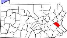 | |
| Boroughs | ||
| Townships | ||
| CDPs | ||
| Unincorporated communities |
| |
| Footnotes | ‡This populated place also has portions in an adjacent county or counties | |