Turtuk
Turtuk is one of the northernmost villages in India and is situated in the Leh district of Ladakh[1][2] in the Nubra Tehsil. It is 205 km from Leh, the district headquarters, and is on the banks of the Shyok River.[3] It is the headquarters of eponymous community development block and is the only Balti region under the Indian administration.[4] It was under Pakistan's control until 1971,[5] after which India gained control over this strategic area.[6][7] Geographically, Turtuk lies in the Baltistan Region and is one among four such villages in India, the other three being Tyakshi, Chalunkha and Dhothang. [8] The residents of Turtuk and its adjoining villages speak Balti language along with Ladakhi and Urdu.[9] Turtuk is the last outpost of India at Dhothang after which Pakistan-controlled Gilgit-Baltistan begins.[10] Turtuk is one of the gateways to the Siachen Glacier.[11][12] Turtuk is known for its varieties of fruits especially apricots.
Turtuk | |
|---|---|
Village | |
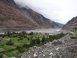 Shyok river at Turtuk | |
 Turtuk  Turtuk | |
| Coordinates: 34.847°N 76.827°E | |
| Country | |
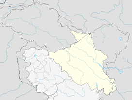
| Union Territory | Ladakh |
| District | Leh |
| Tehsil | Nubra |
| Government | |
| • Type | Panchayati raj |
| • Body | Gram panchayat |
| Population (2011) | |
| • Total | 3,371 |
| Languages | |
| • Official | Balti, Ladakhi, Urdu/Hindi |
| Time zone | UTC+5:30 (IST) |
| PIN | 194401 |
| Census code | 913 |
Geography
The village is in the Shyok Valley. It used to be on the Silk Route with regular trade caravans passing by, shepherded by Baltis.[13]
History
Indo-Pakistan conflicts
At the end of the Indo-Pakistani War of 1947, Turtuk came under the control of Pakistan. Three other villages- Dhothang, Tyakshi (earlier called Tiaqsi) and Chalunka of Chorbat Valley, came under control of India.[14][15] India's Ladakh Scouts and Nubra Guards under the command of Brigadier Udai Singh Bhati and his second in command Major Chewang Rinchen recaptured it during the Indo-Pakistani War of 1971. Brigadier Udai Singh Bhati and Major Rinchen were both honoured with a Maha Vir Chakra for their gallantry and a street is named after Major Rinchen in Leh.[16]
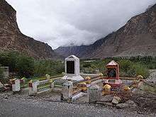
In 1999, the two countries once again had a major conflict around this area during the Kargil War. There are a few memorials built in memory of soldiers on Main Road going towards the zero point of the India–Pakistan Line of Control.
Balti scholar Senge Sering states that Pakistan's Inter-Services Intelligence (ISI) has attempted to introduce jihad into this area. The local people are confused about their loyalties because they lived under both Pakistani and Indian control, some of them having served in the Pakistan Army before India's take-over. Many of them also have relatives living across the Line of Control who are subject to intimidation by the ISI. During the Kargil infiltration by Pakistan, some of the local people were suspected to have assisted the infiltrators. The Indian Army took some of them into custody, but later released all of them. The local people are said to be grateful for the consideration shown by the Army and currently support the Army's initiatives such as the Operation Sadbhavana.[17]
2010 floods
In August 2010, the village of Turtuk was impacted by floods which occurred throughout the entire region of Ladakh.
Tourism in and around Turtuk

Turtuk was opened to tourists in 2010.[18] The village offers views of the Shyok Valley.
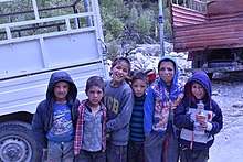
Though a Muslim village, there are a few gompas located on the plateau above the Shyok River and there is an old royal house to see in the village. Turtuk is one of the few places in India where one can witness Balti culture, and one can find a few homestays and guest houses in the village. It is the last major village where tourist activity is allowed before the Line of Control.
Attractions
1. Natural cold storage
2. Historic polo ground
3. Ruins of Brokpa fort
4. Balti Heritage House and Museum
5. Turtuk Museum
7. Water mill
8. Blacksmith
9. 16th century mosque
10. Monastery
11. Traditional handloom
12. Waterfall
Demographics
According to the 2011 census of India, Turtok has 384 households. The effective literacy rate (i.e. the literacy rate of population excluding children aged 6 and below) is 82.53%.[19]
| Total | Male | Female | |
|---|---|---|---|
| Population | 3371 | 2429 | 942 |
| Children aged below 6 years | 343 | 154 | 189 |
| Scheduled caste | 0 | 0 | 0 |
| Scheduled tribe | 1766 | 839 | 927 |
| Literates | 2499 | 2115 | 384 |
| Workers (all) | 2274 | 1953 | 321 |
| Main workers (total) | 2047 | 1840 | 207 |
| Main workers: Cultivators | 371 | 200 | 171 |
| Main workers: Agricultural labourers | 2 | 1 | 1 |
| Main workers: Household industry workers | 1 | 1 | 0 |
| Main workers: Other | 1673 | 1638 | 35 |
| Marginal workers (total) | 227 | 113 | 114 |
| Marginal workers: Cultivators | 50 | 7 | 43 |
| Marginal workers: Agricultural labourers | 3 | 3 | 0 |
| Marginal workers: Household industry workers | 0 | 0 | 0 |
| Marginal workers: Others | 174 | 103 | 71 |
| Non-workers | 1097 | 476 | 621 |
References
- "Blockwise Village Amenity Directory" (PDF). Ladakh Autonomous Hill Development Council. Retrieved 23 July 2015.
- "The village divided by border".
- "Turtuk, the village on the India-Pak border, is where the clichés stop and fantasies begin".
- "the village that lost its country".
- "In Ladakh's Turtuk village, life goes on as it has since the 15th century".
- "Turtuk Diary".
- "Planning a trip to Ladakh? You just cannot miss these experiences".
- https://thewire.in/123835/turtuk-story-of-a-promise-land/
- http://www.risingkashmir.com/news/turtuk-44-years-of-unwanted-domicile/
- "A 'battle' in the snowy heights".
- "Siachen Factor".
- http://thediplomat.com/2014/04/the-siachen-saga/
- "How one woman's story changed the lives of Turtuk's women forever".
- "Turtuk, a Promised Land Between Two Hostile Neighbours".
- "An encounter with the 'king' of Turtuk, a border village near Gilgit-Baltistan".
- Claude Arpi, Have you heard about this Indian Hero?, Rediff News, 22 December 2011.
- Senge H. Sering, "Reclaiming Nubra" – Locals Shunning Pakistani Influences, Institute for Defence Studies and Analyses, Delhi, 17 August 2009.
- "An encounter with the 'king' of Turtuk, a border village near Gilgit-Baltistan".
- "Leh district census". 2011 Census of India. Directorate of Census Operations. Retrieved 23 July 2015.
Further reading
- Turtuk, the village on the India-Pak border, is where the clichés stop and fantasies begin, Hindustan Times, 8 May 2015.
| History |
| ||||||||
|---|---|---|---|---|---|---|---|---|---|
| Administration | |||||||||
| Geography |
| ||||||||
| Settlements and locations | |||||||||
| Districts | |||||||||
| Dam |
| ||||||||
| Monasteries | |||||||||
| Transport | |||||||||
| See also | |||||||||