Demchok
Demchok (Tibetan: ཌེམ་ཆོག, Wylie: Demchog, ZYPY: Dêmqog , historical: bDe-mChog[3]), also spelled Demjok, is a village and military encampment in the disputed Demchok sector between China and India. It is administered as part of the Nyoma tehsil in the Leh district of Ladakh by India,[1][4] and claimed by China as part of the Tibet Autonomous Region.[5]:39
Demchok | |
|---|---|
Village | |
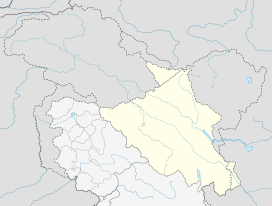 Demchok Location in Ladakh, India  Demchok Demchok (India) | |
| Coordinates: 32.699910°N 79.449520°E | |
| Country | India |
| State | Ladakh |
| District | Leh |
| Tehsil | Nyoma |
| Panchayat | Koyul |
| Government | |
| • Sarpanch | Ugrain Chodon |
| Area | |
| • Total | 33 ha (82 acres) |
| Elevation | 4,200 m (13,800 ft) |
| Population (2011) | |
| • Total | 78 |
| • Density | 240/km2 (610/sq mi) |
| Time zone | UTC+5:30 (IST) |
| Census code | 906 |
| [1][2] | |
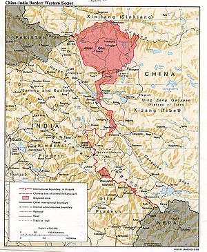
The Line of Actual Control (LAC) passes along the southeast side of the village, following the Charding Nullah upstream from the nearby Indus River. Across that stream, less than a kilometre away, is a Chinese-administered village, called Dêmqog.[6] The Indian-claimed border extends 3 miles (4.8 km) southeast of Demchok, while the Chinese-claimed border extends 10 miles (16 km) northwest of Demchok.[5]:39,48
Description
This village was on an old route linking Ladakh and Tibet along the bank of the Indus River, which is closed as of 2005.[7] Though the Kailash Lake Manasarovar is 300 km away, the route there is mostly through plains.[8]
The village lies 36.5 km east of Ukdungle (32.6015°N 78.9651°E). The world’s highest motorable road passing through the Umling La pass (32.6964°N 79.2842°E) in Ladakh at a height of 19,300 feet (5,900 m) connects to Demchok.[9][10]
Demographics
Demchok (ཌེམ་ཆོཀ་) had 31 households according to the 2011 census of India. The effective literacy rate (i.e. the literacy rate of population excluding children aged 6 and below) is 42.47%.[11]
| Total | Male | Female | |
|---|---|---|---|
| Population | 78 | 43 | 35 |
| Children aged below 6 years | 5 | 4 | 1 |
| Scheduled caste | 1 | 1 | 0 |
| Scheduled tribe | 64 | 37 | 27 |
| Literates | 31 | 20 | 11 |
| Workers (all) | 51 | 27 | 24 |
| Main workers (total) | 49 | 26 | 23 |
| Main workers: Cultivators | 5 | 5 | 0 |
| Main workers: Agricultural labourers | 0 | 0 | 0 |
| Main workers: Household industry workers | 2 | 0 | 2 |
| Main workers: Other | 42 | 21 | 21 |
| Marginal workers (total) | 2 | 1 | 1 |
| Marginal workers: Cultivators | 0 | 0 | 0 |
| Marginal workers: Agricultural labourers | 0 | 0 | 0 |
| Marginal workers: Household industry workers | 0 | 0 | 0 |
| Marginal workers: Others | 2 | 1 | 1 |
| Non-workers | 27 | 16 | 11 |
References
- "Blockwise Village Amenity Directory" (PDF). Ladakh Autonomous Hill Development Council. Archived from the original (PDF) on 9 September 2016. Retrieved 23 July 2015.
- Lack of infra forcing people to migrate from frontier, The Tribune, Chandigar, 17 July 2019.
- Antiquities of Indian Tibet, Part (Volume) II, by A. H. Francke and edited by F. W. Thomas, (1926), pages 115-116.
- https://leh.nic.in/about-district/administrative-setup/village/
- Lamb, Alastair (1965). "Treaties, Maps and the Western Sector of the Sino-Indian Boundary Dispute" (PDF). The Australian Year Book of International Law. 1 (1): 37–52.
- "Ladakhis deplore Krishna's remark on Demchok road". Archived from the original on 24 December 2013. Retrieved 31 May 2008.
- "hindu.com - Ladakhis await re-opening of this historic Tibet route". Archived from the original on 8 November 2012. Retrieved 27 July 2015.
- "expressindia.com - 'Issue of opening Demchok road with China taken up'". Archived from the original on 19 September 2012. Retrieved 27 July 2015.
- "BRO builds world's highest motorable road in Ladakh at 19,300 feet". Archived from the original on 2 November 2017. Retrieved 2 November 2017.
- "Achievements of West Dte during the F/Y 2016-17" (PDF). Archived (PDF) from the original on 7 November 2017. Retrieved 2 November 2017.
- "Leh district census". 2011 Census of India. Directorate of Census Operations. Archived from the original on 24 July 2015. Retrieved 23 July 2015.
External links
- Demchok Western Sector (Chinese claim), OpenStreetMap
- Demchok Eastern Sector (Indian claim), OpenStreetMap
| History |
| ||||||||
|---|---|---|---|---|---|---|---|---|---|
| Administration | |||||||||
| Geography |
| ||||||||
| Settlements and locations | |||||||||
| Districts | |||||||||
| Dam |
| ||||||||
| Monasteries | |||||||||
| Transport | |||||||||
| See also | |||||||||