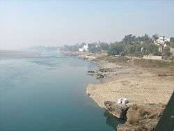
Chenab River
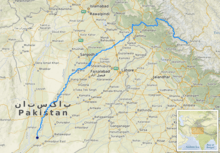
The Chenab River (Sanskrit: असिक्नी asikni; Hindi: चिनाब cināb; Punjabi: ਚਨਾਬ cenab; Urdu: چناب čanāb) is a major river that flows in India and Pakistan, and is one of the 5 major rivers of the Punjab region. It rises in the upper Himalayas in the Lahaul and Spiti district of Himachal Pradesh state, India, and flows through the Jammu region of Jammu and Kashmir into the plains of Punjab, Pakistan, before flowing into the Indus River near the city of Uch Sharif. The waters of the Chenab were allocated to Pakistan under the terms of the Indus Waters Treaty.[3][4]
| Chenab असिक्नी/ चिनाब / ਚਨਾਬ / چناب | |
|---|---|
 | |
 | |
| Location | |
| Country | India, Pakistan |
| Flows through (areas in India) | Chamba-Kishtwar-Thathri-Doda-Ramban-Akhnoor |
| Flows through (areas in Pakistan) | Punjab-Uch |
| Physical characteristics | |
| Source | Baralacha La pass |
| ⁃ location | India Himachal Pradesh |
| ⁃ coordinates | 32°38′09″N 77°28′51″E |
| Mouth | Confluence with Sutlej to form the Panjnad River |
⁃ location | Bahawalpur district, Punjab, Pakistan |
⁃ coordinates | 29°20′57″N 71°1′41″E |
| Length | 960 km (600 mi)approx. |
| Discharge | |
| ⁃ location | Akhnoor[1] |
| ⁃ average | 800.6 m3/s (28,270 cu ft/s) |
| Basin features | |
| Tributaries | |
| ⁃ right | Marusadar River[2] |
The river is formed by the confluence of two rivers, Chandra and Bhaga, at Tandi, 8 km southwest of Keylong, in the Lahaul and Spiti district in the Indian state of Himachal Pradesh. The Bhaga river originates from Surya taal lake, which is situated a few kilometers east of the Bara-lacha la pass in Himachal Pradesh. The Chandra river originates from glaciers east of the same pass.[5] This pass also acts as a water-divide between these two rivers.[6] The Chandra river transverses 115 km (71 mi) before the confluence. The Bhaga river transverses through narrow gorges a distance of 60 km (37 mi) before the confluence at Tandi.[7]
Name
The Chenab river was called Asikni (Sanskrit: असिक्नी) in the Rigveda (VIII.20.25, X.75.5). The name meant that it was seen to have dark-coloured waters.[8][9] The term Krishana is also found in the Atharvaveda.[10] A later form of Askikni was Iskamati (Sanskrit: इस्कामति) and the Greek form was Ancient Greek: Ἀκεσίνης - Akesínes; Latinized to Acesines.[11][8][9]
In the Mahabharata, the common name of the river was Chandrabhaga (Sanskrit: चंद्रभाग) because the river is formed from the confluence of the Chandra and the Bhaga rivers.[10][12] This name was also known to the Ancient Greeks, who Hellenised it in various forms such as Sandrophagos, Sandabaga and Cantabra.[9]
The simplification of Chandrabhaga to 'Chenab', with evident Persianate influence, probably occurred in early medieval times and is witnessed in Alberuni.[13]
History
The river was known to Indians in the Vedic period[14][15][16] In 325 BC, Alexander the Great allegedly founded the town of Alexandria on the Indus (present day Uch Sharif or Mithankot or Chacharan in Pakistan) at the confluence of the Indus and the combined stream of Punjab rivers (currently known as the Panjnad River).[17]
Dams
The river has rich power generation potential in India.
- Salal Dam - 690 MW hydroelectric power project near Reasi
- Dul Hasti Hydroelectric Plant - 390 MW type power project in Kishtwar District
- Pakal Dul Dam - a proposed dam on a tributary Marusadar River in Kishtwar District
- Ratle Hydroelectric Plant - an under construction power station near Drabshalla in Kishtwar District
- Kiru Hydroelectric Power Project (624 MW proposed) located in Kishtwar district
- Kwar Hydroelectric Power Project (540 MW proposed) located in Kishtwar district
All of these are "run-of-the-river" projects as per the Indus Water Treaty of 1960. The Treaty allocates the Chenab River to Pakistan for exploitation. India can use its water for domestic and agricultural uses or for "non-consumptive" uses such as hydro power. India is entitled to store up to 1.2 MAF of water in its projects. The three projects completed so far (Salal, Baglihar and Dul Hasti) have a combined storage capacity of 0.26 MAF.[18]
Pakistan has four headworks on the Chenab:
- Marala Headworks - located near Sialkot
- Khanki Headworks - located in Gujranwala District
- Qadarabad Headworks - located in Hafizabad District
- Trimmu Barrage - located in Jhang District
See also
References
- ftp://daac.ornl.gov/data/rivdis/STATIONS.HTM%5B%5D, ORNL, Retrieved 8 Dec 2016
- "Construction of power projects over Chenab". Business Recorder. 26 August 2013. Retrieved 16 March 2017.
- "River Chenab" (PDF). Archived from the original (PDF) on 27 September 2007. Retrieved 8 December 2016.
- "Indus Waters Treaty". The World Bank. Retrieved 8 December 2016.
- Gosal, G.S. (2004). "Physical Geography of the Punjab" (PDF). Journal of Punjab Studies. Center for Sikh and Punjab Studies, University of California. 11 (1): 31. ISSN 0971-5223. Archived from the original (PDF) on 8 June 2012. Retrieved 6 August 2009.
- R. K. Pant; N. R. Phadtare; L. S. Chamyal & Navin Juyal (June 2005). "Quaternary deposits in Ladakh and Karakoram Himalaya: A treasure trove of the palaeoclimate records" (PDF). Current Science. 88 (11): 1789–1798. Retrieved 6 August 2009.
- Lahaul & Spiti
- Kapoor, Subodh (2002), Encyclopaedia of Ancient Indian Geography, Cosmo Publications, p. 80, ISBN 978-81-7755-298-0
- Kaul, Antiquities of the Chenāb Valley in Jammu 2001, p. 1.
- Kaul, Antiquities of the Chenāb Valley in Jammu 2001, p. 2.
-

- Handa, O. C.; Omacanda Hāṇḍā (1994), Buddhist Art & Antiquities of Himachal Pradesh, Upto 8th Century A.D., Indus Publishing, pp. 126–, ISBN 978-81-85182-99-5
- Kazmi, Hasan Askari (1995), The makers of medieval Muslim geography: Alberuni, Renaissance, p. 124
- Yule, Henry; Burnell, Arthur Coke; Crooke, William (1903). Hobson-Jobson: A glossary of Anglo-Indian colloquial words & phrases and of kindred terms. Murray. p. 741.
chenab ancient name.
- https://www.britannica.com/place/Chenab-River, Chenab River on Encyclopædia Britannica, Retrieved 8 Dec 2016
- Encyclopædia Britannica article on the Chenab
- Alexandria (Uch)
- Bakshi, Gitanjali; Trivedi, Sahiba (2011), The Indus Equation (PDF), Strategic Foresight Group, p. 29, retrieved 28 October 2014
Bibliography
| Wikisource has the text of the 1911 Encyclopædia Britannica article Chenab. |
| Wikimedia Commons has media related to Chenab River. |
- Kaul, P. K. (2001), Antiquities of the Chenāb Valley in Jammu: Inscriptions-copper Plates, Sanads, Grants, Firmāns & Letters in Brāhmi-Shārdā-Tākri-Persian & Devnāgri Scripts, Eastern Book Linkers
| Inland |
|
|---|---|
| Coastal | |
| Categories |
|
| Lakes |  | |
|---|---|---|
| Rivers | ||
| Districts | ||
| Other |
| |
Punjab geography | ||
|---|---|---|
| ||