Khurnak Fort
The Khurnak Fort is a ruined 19th century fort in western Tibet Autonomous Region, China. It is in the disputed Aksai Chin region claimed by India.
| Khurnak Fort | |
|---|---|
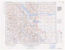
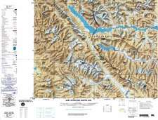
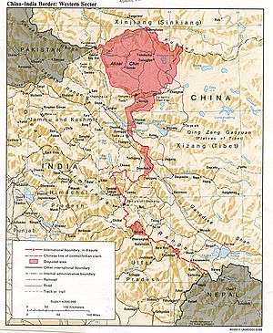 1988 CIA map showing Khurnak Fort in Aksai Chin | |
| Coordinates | 33.7667°N 78.9877°E |
| Elevation | 4257 meters |
| Country | China |
| Region | Tibet |
| Khurnak Fort | |||||||
|---|---|---|---|---|---|---|---|
| Traditional Chinese | 庫爾納克堡 | ||||||
| Simplified Chinese | 库尔纳克堡 | ||||||
| |||||||
| Alternative Chinese name | |||||||
| Traditional Chinese | 庫爾那克堡 | ||||||
| Simplified Chinese | 库尔那克堡 | ||||||
| |||||||
Description
The fort lies close to the northern bank of the Pangong Tso and has an elevation of 4257 meters above sea level.[1] It is situated on a rock in the northwestern part of the Khurnak plain.[2]:72[3]:355
History
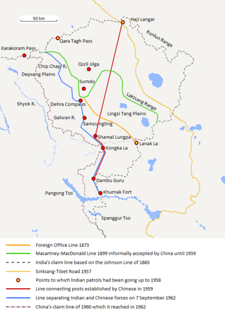
In 1863, British topographer Henry Haversham Godwin-Austen described Khurnak as a disputed plain claimed both by inhabitants of the Panggong district and Tibetan authorities from Lhasa. He personally believed that it should belong to the latter due to the "old fort standing on a low rock on the north-western side of the plain" previously built by the Tibetans.[2]:72[3]:355 Godwin-Austen remarked that the Kashmiri authorities in Leh had recently exerted their influence in the region such that Khurnak was effectively controlled by the Maharaja of Jammu and Kashmir.[2]:72[3]:355
According to Alastair Lamb, the majority of British maps published between 1918 and 1947 showed Khurnak as being in Tibet.[2]:39
The boundary between India and China was considered to be at the Khurnak Fort[4][5] and Indian forces visited it from time to time and had a post there.[4] China wrested its control since around July 1958, according to most sources.[4][6][7][8][9][10]
During the 1960 talks between the two governments on the boundary issue, India submitted official records including the 1908 Settlement Report, which recorded the amount of revenue collected at Khurnak, as proof of jurisdiction over Khurnak.[11] The Chinese claim line of 1956 did not include the Khurnak Fort, but the 1960 claim line included the Khurnak Fort.[12]
In 1963, Khurnak Fort was described by the US National Photographic Interpretation Center as follows:
Location--33-44N 78-59E, 20 nm north-east of Chushul, on the north shore of PangongTso. Facilities--one large barracks-type building, 2 large storage-type buildings, and 9 smaller buildings; dry moat on three sides; six AW positions and several individual firing positions. Served by natural surface road; no vehicles observed.[13]
As of 2019, a PLA border patrol company of the Western Theater Command is stationed nearby.[14]
See also
Notes
- From map: "THE DELINEATION OF INTERNATIONAL BOUNDARIES ON THIS MAP MUST NOT BE CONSIDERED AUTHORITATIVE"
References
- "Khurnak Fort". Retrieved 29 August 2013.
- Lamb, Alastair (1965). "Treaties, Maps and the Western Sector of the Sino-Indian Boundary Dispute" (PDF). The Australian Year Book of International Law. 1 (1): 37–52.
- Godwin-Austen, H. H. (1867). "Notes on the Pangong Lake District of Ladakh, from a Journal Made during a Survey in 1863". Journal of the Royal Geographical Society of London. 37: 343–363. doi:10.2307/1798534.
- Pg. 74, La Question de la frontière Sino-Indienne, 1967
- Negi, S.S. (2002). Cold Deserts of India (Second ed.). Indus Publishing. p. 66. Retrieved 13 August 2014.
- Gonon, Emmanuel (2011). Marches et frontières dans les Himalayas. Presses Universite Du Quebec. p. 206. ISBN 2760527034.
- N. Jayapalan. Foreign Policy of India. p. 206. Retrieved 30 August 2013.
- K. V. Krishna Rao. Prepare Or Perish: A Study of National Security. p. 75. Retrieved 30 August 2013.
- M. L. Sali. India-China Border Dispute: A Case Study of the Eastern Sector. p. 82. Retrieved 30 August 2013.
- Praveen Swami. "China's Ladakh intrusion: Two maps tell this dangerous story". Firstpost. Retrieved 30 August 2013.
- Fisher, Margaret W.; Rose, Leo E.; Huttenback, Robert A. (1963). Himalayan Battleground: Sino-Indian Rivalry in Ladakh. Praeger. p. 111 – via Questia.
- Patterson, George N. (Oct–Dec 1962). "Recent Chinese Policies in Tibet and towards the Himalayan Border States". The China Quarterly (12): 195. JSTOR 651824.
- "SINO-INDIAN BORDER DEFENSE CHUSHUL AREA" (PDF). National Photographic Interpretation Center. February 1963. Archived from the original (PDF) on 23 January 2017. Retrieved 20 May 2020 – via CIA. Alt URL
- China Youth Daily (2019-02-11). "零下20摄氏度!边防官兵巡逻在海拔5700米的雪域高原上" (in Chinese). Sina Corp. Retrieved 6 January 2020.
驻守在班公湖畔的新疆军区某边防团库尔那克堡边防连巡逻分队