Kanji, Ladakh
Kanji is a village in the Leh district of the union territory of Ladakh in India.[1] It is located in the Khalsi tehsil, and can be accessed through the village of Heniskot which lies on the Srinagar-Kargil-Leh highway.
Kanji | |
|---|---|
village | |
 Kanji Village | |
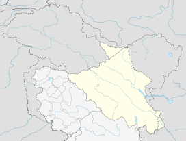 Kanji Location in Ladakh, India  Kanji Kanji (India) | |
| Coordinates: 34.25°N 76.6°E | |
| Country | India |
| Union Territory | Ladakh |
| District | Leh |
| Tehsil | Khalsi |
| Elevation | 3,875 m (12,713 ft) |
| Population (2011) | |
| • Total | 325 |
| Time zone | UTC+5:30 (IST) |
| 2011 census code | 958 |
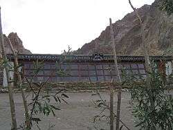
Primary school, Kanji
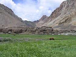
The village has a small number of families who farm the immediate area. The village is situated on an altitude of 3875 m, and is a campsite on the Kanji la and Shilakong gorge treks.
Demographics
According to the 2011 census of India, Kanji has 52 households. The effective literacy rate (i.e. the literacy rate of population excluding children aged 6 and below) is 62.19%.[2]
| Total | Male | Female | |
|---|---|---|---|
| Population | 325 | 165 | 160 |
| Children aged below 6 years | 42 | 20 | 22 |
| Scheduled caste | 0 | 0 | 0 |
| Scheduled tribe | 324 | 165 | 159 |
| Literates | 176 | 94 | 82 |
| Workers (all) | 139 | 74 | 65 |
| Main workers (total) | 138 | 74 | 64 |
| Main workers: Cultivators | 65 | 37 | 28 |
| Main workers: Agricultural labourers | 7 | 1 | 6 |
| Main workers: Household industry workers | 56 | 30 | 26 |
| Main workers: Other | 10 | 6 | 4 |
| Marginal workers (total) | 1 | 0 | 1 |
| Marginal workers: Cultivators | 0 | 0 | 0 |
| Marginal workers: Agricultural labourers | 0 | 0 | 0 |
| Marginal workers: Household industry workers | 0 | 0 | 0 |
| Marginal workers: Others | 1 | 0 | 1 |
| Non-workers | 186 | 91 | 95 |
References
- "Blockwise Village Amenity Directory" (PDF). Ladakh Autonomous Hill Development Council. Retrieved 23 July 2015.
- "Leh district census". 2011 Census of India. Directorate of Census Operations. Retrieved 23 July 2015.
| History |
| ||||||||
|---|---|---|---|---|---|---|---|---|---|
| Administration | |||||||||
| Geography |
| ||||||||
| Settlements and locations | |||||||||
| Districts | |||||||||
| Dam |
| ||||||||
| Monasteries | |||||||||
| Transport | |||||||||
| See also | |||||||||
This article is issued from Wikipedia. The text is licensed under Creative Commons - Attribution - Sharealike. Additional terms may apply for the media files.