Dras
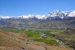
Dras (also spelt Drass. ISO transliteration: Drās), a tourist hub for its high altitude trekking routes and tourist sites, is a Hill Station in the Kargil district of the union territory of Ladakh in India. It is on the NH 1 (former name NH 1D before renumbering of all national highways) between Zoji La pass and Kargil town. It is often called "The Gateway to Ladakh".[3] The government's official spelling of the town is Drass.
Dras Drass | |
|---|---|
Hill Station | |
 Dras | |
| Nickname(s): The Gateway to Ladakh | |
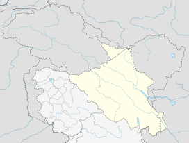 Dras Location in Ladakh, India  Dras Dras (India) | |
| Coordinates: 34.4307175°N 75.7516836°E | |
| Country | |
| Union Territory | Ladakh |
| District | Kargil |
| Tehsil | Dras[1] |
| Elevation | 3,300 m (10,800 ft) |
| Population | |
| • Total | 1,201 |
| Languages | |
| • Official | Urdu, Balti language, Shina language |
| Time zone | UTC+5:30 (IST) |
| PIN | 194102 |
| Website | kargil |
Etymology
Traditionally Dras is known as Hem-babs means "snow land" with the word "Hem" meaning snow. It is noted as "the second coldest inhabited place in the world" although it isn't. The average temperature of Dras is 2 degrees celsius. There are many inhabited place in the world with average temperature lower than 2 degrees celsius [4]
Geography
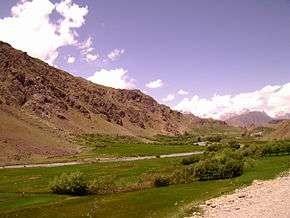
Dras town is located at 34.4306603°N 75.751552°E. It is often called "The Gateway to Ladakh". It is at a height of 10,800 feet (3,300 m)[2] Dras lies in the centre of the valley of the same name (Dras valley). Dras is 140 km from Srinagar and 63 km from Sonmarg. Kargil town is further 56 km after Dras on the national highway NH 1 from Srinagar towards Leh.
History

In the princely state of Jammu and Kashmir (1846–1947), Dras was part of the Kargil tehsil of the Ladakh wazarat.[5]
During the invasion by Pakistan in 1947-48, the reinforced Gilgit Scouts, having gone over to Pakistan, attacked the Kargil area on 10 May 1948. The Indian army, which was by now in charge of the defence of Kashmir, sent reinforcements. However, they could not reach Dras in time and Dras fell to the Gilgitis on 6 June 1948. Kargil and Skardu also fell in short order.[6] In November 1948, the Indian Army launched Operation Bison, supported by tanks, and retook Dras and Kargil. Skardu, however, remained under the control of Pakistan.[7] The 1949 ceasefire line runs 12 km north of Dras through Point 5353.[8]
The ceasefire line was renamed the Line of Control in the 1972 Simla Agreement, by which India and Pakistan agreed to respect the line without prejudice to their stated positions.
However, in the early months of 1999, Pakistani soldiers, masquerading as mujahideen, infiltrated into the area and took control of the peaks overlooking Dras and the highway, in particular Tololing, 4 km from Dras, and Tiger Hill, 8 km from Dras. They directed artillery fire at Dras and the highway, leading to the Kargil War. The Indian army cleared the Tololing and Tiger Hill peaks by July 1999. In 1965 war,dras cantonment was a sight of commando action by special service group killing 412 indian troops and destroying the whole cantonment a classing behind enemy line raid
Climate
| Dras | ||||||||||||||||||||||||||||||||||||||||||||||||||||||||||||
|---|---|---|---|---|---|---|---|---|---|---|---|---|---|---|---|---|---|---|---|---|---|---|---|---|---|---|---|---|---|---|---|---|---|---|---|---|---|---|---|---|---|---|---|---|---|---|---|---|---|---|---|---|---|---|---|---|---|---|---|---|
| Climate chart (explanation) | ||||||||||||||||||||||||||||||||||||||||||||||||||||||||||||
| ||||||||||||||||||||||||||||||||||||||||||||||||||||||||||||
| ||||||||||||||||||||||||||||||||||||||||||||||||||||||||||||
Dras is the coldest place in India, experiencing an altitude-influenced mediterranean continental climate (Köppen climate classification Dsb). Winters are cold with average lows around −20 °C (−4 °F), and as low as −23 °C at the height of winter, which lasts from mid-October to mid-May. Summers start in June and go on up till early September, with average temperatures near 23 °C (74 °F) and little precipitation. Annual precipitation is almost entirely concentrated from December to May when Dras gets around 550 millimetres (21.7 in) water equivalent of snowfall.
| Climate data for Dras | |||||||||||||
|---|---|---|---|---|---|---|---|---|---|---|---|---|---|
| Month | Jan | Feb | Mar | Apr | May | Jun | Jul | Aug | Sep | Oct | Nov | Dec | Year |
| Record high °C (°F) | 5 (41) |
6 (43) |
10 (50) |
18 (64) |
25 (77) |
30 (86) |
33 (91) |
31 (88) |
29 (84) |
25 (77) |
15 (59) |
9 (48) |
33 (91) |
| Average high °C (°F) | −8 (18) |
−6 (21) |
−1 (30) |
5 (41) |
14 (57) |
21 (70) |
24 (75) |
24 (75) |
20 (68) |
13 (55) |
4 (39) |
−3 (27) |
9 (48) |
| Daily mean °C (°F) | −15 (5) |
−14 (7) |
−8 (18) |
0 (32) |
7 (45) |
13 (55) |
16 (61) |
17 (63) |
12 (54) |
6 (43) |
−3 (27) |
−9 (16) |
2 (36) |
| Average low °C (°F) | −23 (−9) |
−22 (−8) |
−15 (5) |
−6 (21) |
1 (34) |
6 (43) |
9 (48) |
10 (50) |
5 (41) |
−1 (30) |
−10 (14) |
−16 (3) |
−5 (23) |
| Record low °C (°F) | −42 (−44) |
−43 (−45) |
−33 (−27) |
−25 (−13) |
— | −8 (18) |
−5 (23) |
−5 (23) |
−5 (23) |
−20 (−4) |
−29 (−20) |
−45 (−49) |
−43 (−45) |
| Average precipitation mm (inches) | 96.5 (3.80) |
99.6 (3.92) |
137.1 (5.40) |
104.1 (4.10) |
60.9 (2.40) |
22.3 (0.88) |
15.2 (0.60) |
16.2 (0.64) |
17.7 (0.70) |
20.3 (0.80) |
32.5 (1.28) |
53.3 (2.10) |
675.7 (26.62) |
| Source: | |||||||||||||
Demographics
The major ethnic groups are the Shina people, who speak the Indo-Aryan language Shina, and the Balti people, whose language, Balti, belongs to the Tibetic group. The small town has a majority of people following Islam. The local population is of 64% male and 36% female. In total the population of Dras is 1,201.[9]
Tourism
Dras has been developed as a tourist destination since 1999, following the Kargil War. This new facet of the local economy initially took the form of visitors specifically arriving to see the war zone.[10] Notable places include:
- Manman Top, 10 km from Dras, from where one can view the Dras Valley and the LOC [Line of Control – see also LOC Kargil])
- Gomchan Valley, 5 km from Dras (a highland valley with glacier and steam running through)
- Dongchik, 10 km from Dras (a model village in terms of agriculture, education and peace. Only village with zero cases as per police record)
- Ningoor Masjid, Bhimbet, 7 km from Dras (a mosque which is thought to have the Allah's special blessings. One wall of which was believed to be raised naturally during construction. This Masjid is visited by Muslim pilgrims)
- Bhimbet Stone, 7 km from Dras (a holy stone for Hindu pilgrims)
- Dras War Memorial, 7 km from Dras (also known as Kargil War Memorial)
- Draupadi Kund – 18 km from Dras
- Minamarg (a valley 30 km from Dras headquarters, hills of which is bounded by Machoi Glaciers and also is a traditional route to Amarnath Yatra)
- Matayen (a village 20 km from Dras is the only village of Ladakh having Kashmiri speaking people)
- Laser La (a hill station about 14 km from Dras, especially known for its milkwhite water and Laser La glacier)
- Chorkiat Forest (near the LOC about 20 km from Dras and 5 km from Dongchik, is a natural forest area with a number of wild animals)
- Tiasbu Astana 2 km from Dras (a religious place for Muslims)
- Sando Top/Sando Base 8 km from Dras – Pakistani posts are visible from Sando Top, and Tiger Hill is located in front of Sando Top (1 hour drive away from Dras).
- Mushku Valley 8 km from Dras (popular for various wild flowers during summer season in the deserted Ladakh region)
- Dras-Gurez Trek Route (a trek route from Dras, Ladakh to Gurez, Bandipora in Kashmir which runs through Mushku Valley, Botakul and mountains (vehicular road also links Dras with Gurez)
- Brigade War Gallery 3 km from Dras – information relating to the 1999 war.
- Pandrass village 13 km from Dras – border village that was evacuated during the 1999 war.
- Tololing Waterfall – it is the only waterfall in the Ladakh Region located 10km from Dras. It is under the rocky mountains of the Tololing Hill.
- Tsochak Lake – located in the Tololing hills about 15km from Dras. It is located at an altitude of 15,420 ft above the sea level. It is a fresh water lake.
- Goshan Valley – it is a green valley about 2km from Dras. It is believed that the village was founded by a person known as Mon-Choto and his family. After they were forced to leave their home in Chilas, Gilgit Baltistan. They said to have been the first settler in Drass.
- Gangzla Trek – it is a 2 days trek from Dras To Gangzla (which is now known as Tiger Hill) to pay tribute to soldiers who lost their life during 1999 Kargil War. During winter, there is almost 10ft of snow.
- Drass-LaserLa-Saliskote Trek – Three days trek from Dras to Saliskote through laser La top. Laser La is a hill station about 10km from Dras. There is also a waterfall which can be seen from Drass-Kargil highway.
- Amarnath Trek – the trek to Holy Cave of Amarnath starts from Dras, takes almost four to five days and involves crossing a pass of 15,060ft.
- Machoi Glacier – it is located 30km from Dras. The highest peak named after the glacier is Machoi Peak at an elevation of 17,907ft. It is a snow covered glacier all around 12 months. Drass river originates from this glacier.
- Tiger Hill – it is also known as point 5065. It is one the highest peak in the area. It was recaptured by the Indian Army during the 1999 Kargil War between India and Pakistan.
- KBS (Kargil Battle School) – that imparts training to Indian soldiers. After the Kargil War ended, a specialised Kargil Battle School was set up by the Indian Army to train the Jawans in mountain climbing and high altitude warfare.
References
- https://kargil.nic.in/revenue-villages/
- Singh Negi, Sharad (2002). Cold Deserts of India. Indus Publishing. p. 226. ISBN 8173871272.
- "Page on Dras from". ladakh-kashmir.com. Archived from the original on 7 February 2012. Retrieved 15 June 2012.
- Schuh, Dieter (2014). "Drass". Tibet-Encyclopaedia.
- Karim, Kashmir The Troubled Frontiers 2013, pp. 30–31.
- Cheema, Crimson Chinar 2015, pp. 48, 102–103.
- Cheema, Crimson Chinar 2015, pp. 111–112.
- Swami, Praveen (11 August 2000). "Pakistan still occupies key Dras point". The Hindu Business Line. Retrieved 29 September 2017.
- "Page 4. Rambirpur (Drass)". Censusindia.gov.in. Retrieved 15 June 2012.
- Bhan, Mona (2013). Counterinsurgency, Democracy, and the Politics of Identity in India: From Warfare to Welfare?. Routledge. pp. 1, 178–179. ISBN 978-1-13450-983-6.
Bibliography
- Cheema, Brig Amar (2015), The Crimson Chinar: The Kashmir Conflict: A Politico Military Perspective, Lancer Publishers, pp. 51–, ISBN 978-81-7062-301-4
- Karim, Maj Gen Afsir (2013), Kashmir The Troubled Frontiers, Lancer Publishers LLC, pp. 30–, ISBN 978-1-935501-76-3
External links
| Wikimedia Commons has media related to Dras, India. |
| History |
| ||||||||
|---|---|---|---|---|---|---|---|---|---|
| Administration | |||||||||
| Geography |
| ||||||||
| Settlements and locations | |||||||||
| Districts | |||||||||
| Dam |
| ||||||||
| Monasteries | |||||||||
| Transport | |||||||||
| See also | |||||||||