Chorbat Valley
Chorbat Valley (Urdu: وادی چھوربٹ, Balti: སྦལ་ཏིའི་) is a valley in Khaplu tehsil, Ghanche District of Gilgit–Baltistan the region of Pakistan and in south east of Nubra valley, Ladakh, India. It stretches from the northeastern half of Shyouk valley from Abandon village of Pakistani administrated ghanche district to Bogdang village of Indian administrated Nubra valley. Churbat on many occasion is incorporated with Khaplu valley, although virtually it also took it own distinction, Even sometimes it is consider differently (due to its geography and peculiar accent of language). It is the last northeastern valley from where the geography of Baltistan ends, while Ladakh begins.
Chorbat Valley | |
|---|---|
Valley | |
 | |
 Chorbat Valley Kashmir | |
| Coordinates: 34.930°N 76.763°E | |
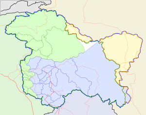
| Country | Pakistan & India |
| Province | Gilgit-Baltistan & Ladakh |
| District | Ghanche & Leh |
| Population (2010) | |
| • Total | 20,000 |
Geography
 |

Chorbat is an indistinct region[1] at the border between Baltistan and Ladakh near the course of the Shyok River. It is marked by
- the Chorbat La pass, the traditional border between Baltistan and Ladakh,[2]
- the Chorbat village in Baltistan, now called Siksa, and
- the town of Turtuk, presently in Nubra, which is considered its traditional capital.[3]
In the early decades of the Jammu and Kashmir princely state, there was a Chorbat ilaqa (subdistrict) in the Baltistan wazarat (district). It stretched along the Shyok River valley from a village called Dou-U (Dawou[4]) in the west to Chalunka in the east.[5]
Between the Chorbat village and the Chorbat La pass lies the Chorbat Lungpa valley.[6][7] To the south of the Chorbat La pass, the Hanu valley carries a stream that flows down to join the Indus River near the village of Dah. The Chorbat Lungpa and Hanu valleys constituted the main route from Baltistan to Ladakh in the past.[2] The villages in the Hanu valley as well as Dah are fortified, indicating that they experienced raids from Baltistan in the past.[2] Being the main travel route between Baltistan and Leh, the route carried part of the Silk Road traffic, which enriched the people of Chorbat.[8]
The main populated areas in Chorbat are in the Shyok River valley, comprising some 13 villages in present day Baltistan, and 5 villages in Indian-administered Ladakh.[4][9] The area is said to have been originally settled by people from Ladakh.[10] At present, the people display a mix of Ladakhi and Balti influences.[11]
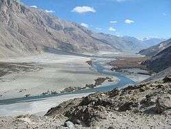
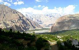
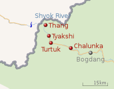
Geographically, the wide valley of the Shyok river in "Lower Nubra" narrows to a mountain gorge near the Yagulung village (34.77°N 77.14°E). The Shyok flows through the gorge until Khaplu, where the valley widens again.[12] A string of villages dot this gorge, wherever possible along the banks of the river: Bogdang, Chalunka, Turtuk, Tyakshi, and Thang on the Indian side of the Line of Control; Franu, Siari, Piun, Siksa, Hassanabad, Marcha, Lunkha, and Dawou on the Pakistani side. The folklore includes all these villages in Chorbat.[4][9]
The valley is surrounded by high rising peaks of the Karakoram mountain range and the bank the Shyok River. The climate is hard with little rain and extremely cold winters due to proximity to Siachen Glacier and other peaks and glaciers.[4]
Chorbat occupies 4,052 square kilometres (1,564 sq mi).
History
According to scholar Rohit Vohra, the original settlers of the area were Brog-pa Dards. Above the present day Turtuk stand the ruins of a large fortress built by them. The tradition holds that the Brog-pa Dards were Buddhist and lived under a constant danger of attack from the north, until two warriors from the 'west' called Chulli and Yandrung overran them. The Brog-pas are said to have fled and settled in the Hanu valley. The present day residents of Turtuk are divided into 'Chulli-pa' and 'Yandrung-pa', claiming descent from Chulli and Yandrung.[13]
At some later date (16th–17th centuries), Islamic missionaries came to the area. The traditions narrate the visits of 'Amir Kabir' (possibly Mir Sayyid Ali Hamadani) and Sayyid Nur Baksh, who defeated the Buddhist lamas in debate and converted the people to Islam.[14]
A Yabghu (Tibetan spelling: Yagbo) family was in control of Khaplu from some uncertain date (c. 850 according to tradition).[15] In the 18th century, the Chorbat area was given by the ruler Yabgo Yahya Khan of Khaplu to his son Yagbo Nasir Khan, who came to live in Turtuk. The present headman of Turtuk traces his descent to him.[14]
Modern history
During the last three centuries, the Chorbat area alternatively came under the control of Khaplu and Ladakh.[1] Between 1834–1840, the Dogra general Zorawar Singh conquered both Ladakh and Baltistan and made them part of the Sikh Empire. Under the Treaty of Amritsar, the areas were transferred to Maharaja Gulab Singh to form part of a new princely state of Jammu and Kashmir under the suzerainty of the British. Baltistan was at first administered as a wazarat with 15 ilaqas, Chorbat being one of them.[16] Later, Ladakh and Baltistan formed a joint wazarat whose capital alternated between Leh and Skardu for six months each year.[17]
India–Pakistan conflicts
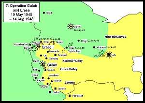
In 1947, after the independence of India and Pakistan, Pakistan launched a tribal invasion of Jammu and Kashmir, which provoked the Maharaja of Jammu and Kashmir to join India. The Gilgit Agency to the north rebelled and overthrew the Maharaja's administration. The Gilgit Scouts and the Muslim members of the Jammu and Kashmir State Forces stationed in the area organised themselves under the command of Colonel Aslam Khan, and launched an invasion on the Ladakh wazarat. By July–August 1948, the Gilgit Scouts overran Kargil, Skardu and the Zoji La pass that connects Ladakh to the Kashmir Valley, reaching the vicinity of Leh.
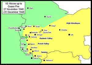
But Leh held, reinforced by air and a tortuous mountain caravan from Himachal Pradesh. The Indian Army raised a local militia called Nubra Guards under the command of 17-year old Chewang Rinchen, which reportedly blocked various passage routes to Leh.[18] The Gilgit Scouts were progressively pushed back beyond the line connecting the Chorbat La pass and Chalunka. The ceasefire line was established through these two points at the end of 1948.[19] The entire Chorbat ilaqa came under the control of Pakistan. (Bogdang, never a part of the ilaqa, remained under Indian control.)
Under Pakistani control, Gilgit dominated Baltistan, and both the regions were administered as a non-descript "Northern Areas" by the Federal government of Paksitan. Chorbat was merged into the Khaplu niabat during this period.[20]
 |
Two further wars were fought by India and Pakistan over Kashmir. In the 1965 war, the region saw some action, but the two countries returned to status quo after the war. However, the Khan of Turtuk, Yagbo Mohammad Khan Kacho, was apparently looted by the Pakistani Army of his throne and all other valuables.[3]
In the war of 1971, Rinchen's Nubra Guards, now part of Ladakh Scouts, proceeded to capture further areas of Chorbat. They first captured a peak at 18,620 feet overlooking Chalunka. Then the two companies of Karakoram Scouts defending Chalunka were overpowered, leading them to flee to Turtuk. Turtuk was then taken in four days, followed by Tyakshi and Thang.[21] The villagers were frightened at first, but Rinchen put them at ease.[22]
Division between India and Pakistan
.jpg)
After the 1971 war, India and Pakistan reached the Simla Agreement, whereby the ceasefire line of the war became the new Line of Control, permanently dividing Chorbat between India and Pakistan. The Baltis allege that the Pakistani prime minister Zulfikar Ali Bhutto did not care about the Balti villages captured by India and neglected to negotiate their return.[23]
One member of a divided family reports going to the border carrying a white flag and a letter from the Indian Army, wanting to bring back his family. But he was detained by the Pakistani Army and refused return to home.[24] According to him, India treated the villagers well and integrated them into the national mainstream. The Indian Army gets special praise in this regard.[25] However, the villagers that had gone to other parts of Pakistan before the war for trade, study or travel remained on the Pakistani side, never allowed to return to their homes.[26]
Balti scholar Senge Sering states that Pakistan's Inter-Services Intelligence (ISI) has attempted to introduce jihad into this area. The local people are confused about their loyalties because they lived under both Pakistani and Indian control, some of them having served in the Pakistan Army before India's take-over. Many of them also have relatives living across the Line of Control who are subject to intimidation by the ISI. During the Kargil infiltration by Pakistan, some of the local people were suspected to have assisted the infiltrators. The Indian Army took some of them into custody, but later released all of them. The local people are said to be grateful for the consideration shown by the Army and currently support the Army's initiatives such as the Operation Sadbhavana.[27]
Resources
The natural resources of the valley include agriculture, horticultural resources, the shyok River, mountains and peaks.
The agriculture in the Valley is only summer based due to extreme cold in the winter where temperature goes to minus 10. The crops include some beans, maize and other food crops however communities have experimented less with the agriculture due to the natural limiting factors i.e. extreme cold.
Chorbat valley consists of more than 13 villages in Pakistan and 5 villages in India. In Pakistan, the villages are Dawou, Marcha, Kuwas, Hassanabad, Partuk, Piun, Siksa, Kalaan, Sukhmos, Chhowar, Thongmus, Siari, & Franu, and in India, they are Doethang, Tyaqsi, Turtuk, Chalunka, and Beyoqdan.[28][29]
Surroundings
The mountains and surrounding have generally no forests however there are some shrubs and herbs available which are generally used by the local communities as medicinal herbs, there is also a human-made forest in the saling which the largest forest in the whole district.
The Shyok River passing nearby the valley is one of the important resources of the area, irrigating the whole land. However the same river sometime creates havoc during summer through its unpredictable floods.
Indian intrusion
Pakistani sources allege that, in 1972, shortly after the signing of the Shimla Agreement, the Indian troops crossed the Line of Control (LoC) in the Chorbat La sector and seized about 4 square miles of Pakistani territory.[30] In 1988, India again crossed the LoC and seized four Pakistani posts in the Qamar sector.[30] In 1992, the Indian troops captured the "Anzbari feature" near Kanzalwan, but following the Director General of Military Operations (DGMO) level talks with Pakistan it was returned.[30] However, after the 1999 Kargil War, India once again captured it.[30]
References
- Vohra, Mythic Lore from Nubra Valley (1990): "The precise dividing point from where the Chorbat area can be demarcated is at present not possible. The Chorbat area, during the last three centuries, continuously changed hands between the rulers of Khapalu and Ladakh."
- Drew, The Jummoo and Kashmir Territories (1875): "The Chorbat Pass is the boundary of Baltistan in this direction; by this road also used to come Balti raiders, as the remains of a fort at Yogma Hanū prove, which the people of the valley had put up against them."
- Nandini Mehta, Turtuk Diary, Outlook, 8 August 2011. Quote: "The Khan of Turtuk, Mohammad Khan Kacho of the Yabgo Dynasty of Chorbat Khaplu, to give him his title in full. His ancestors derived their power and wealth (now sadly reduced) from Turtuk's strategic location on a feeder road of the Silk Route going on to Central Asia via Skardu and Yarkand."
- "Chorbat Valley: The Picturesque Valley of Gilgit Baltistan, Pakistan". Pakistan Source. 8 April 2016. Archived from the original on 23 October 2016.
- Gazetteer of Kashmir and Ladak (1890), p. 274.
- Enriquez, The Realm of the Gods (1915), pp. 210–211.
- Bhattacharji, Ladakh (2012), Ch. 4.
- Archita Suryanarayanan, In Ladakh’s Turtuk village, life goes on as it has since the 15th century, The Hindu, 13 October 2018.
- Chorbat Valley Baltistan, VisitPakistanOnline.com, retrieved 28 July 2019.
- Vohra, Mythic Lore from Nubra Valley (1990).
- Vohra, Mythic Lore from Nubra Valley (1990), p. 225: "The total Muslim population is about 2800 and except for a few families at Hundar (Ladakhi) all of their villages lie in the Chorbat area whose cultural belief system shows a mixture of Ladakhi and Balti influences."
- Shyok river valley between Diskit and Khaplu, OpenStreetMap, retrieved 28 July 2019.
- Vohra, Mythic Lore from Nubra Valley (1990), pp. 229–230.
- Vohra, Mythic Lore from Nubra Valley (1990), p. 231.
- Dani, Ahmad Hasan (1998), "The Western Himalayan States", in M. S. Asimov; C. E. Bosworth (eds.), History of Civilizations of Central Asia, Vol. IV, Part 1 — The age of achievement: A.D. 750 to the end of the fifteenth century — The historical, social and economic setting, UNESCO, p. 220, ISBN 978-92-3-103467-1
- Gazetteer of Kashmir and Ladak (1890), p. 194.
- Afridi, Baltistan in History (1988), p. 266.
- Col J. Francis (2013), Short Stories from the History of the Indian Army Since August 1947, Vij Books India Pvt Ltd, p. 30, ISBN 978-93-82652-17-5: Quoting Col. Mohammad Yusuf of Pakistan Army: "Our intelligence revealed that our repeated attacks in Nubra Valley were foiled by the personal valour of a 17 year old boy named Chhewang Rinchen; had we succeeded at Skuru, there would then have been no real obstacle to our capturing Leh."
- Krishna Rao, Prepare or Perish (1991), p. 472, item (d).
- Afridi, Baltistan in History (1988), p. 241.
- Chakravorty, B. (1995), Stories of Heroism: PVC & MVC Winners, Allied Publishers, pp. 139–140, ISBN 978-81-7023-516-3
- Claude Arpi, Have you heard about this Indian Hero?, Rediff News, 22 December 2011.
- Bouzas, (B)Ordering and the Politics of Belonging (2017), pp. 114–115: Quoting a Balti soldier: "Pakistanis were not interested in these areas because they were mountain regions, although India was willing to return the villages [in the peace conversations of Simla in 1972]. The Pakistani Prime Minister Bhutto negotiated the return of villages in Azad Jammu and Kashmir and Lahore sector but not ours."
- Khan (2017): 'The unworldly villager, not knowing the consequences, told them that the Indian soldiers had not harmed them; instead they took good care of villagers. Hearing this, the Pakistani soldiers suspected him of being a spy for the Indian army and imprisoned him for six years.'
- Khan (2017): 'Mohammad is very fond of the Indian army. “I admire the Indian army and all the help they provided us – food, clothes, education. For me, upar Allah, niche Indian army,” he said.'
- Shabbir Mir, Man reunites with father after 1971 war, The Express Tribune, 5 January 2016: "I was told my land and my family were no longer mine," said Gafoor. "I had lost everything but hope to that war; hope for a reunion one day..."
- Senge H. Sering, "Reclaiming Nubra" – Locals Shunning Pakistani Influences, Institute for Defence Studies and Analyses, Delhi, 17 August 2009.
- "Turtuk, a Promised Land Between Two Hostile Neighbours".
- "An encounter with the 'king' of Turtuk, a border village near Gilgit-Baltistan".
- Cheema, Zafar Iqbal (2009). "The strategic context of the Kargil conflict: A Pakistani perspective". In Peter René Lavoy (ed.). Asymmetric Warfare in South Asia: The Causes and Consequences of the Kargil Conflict (illustrated ed.). Cambridge University Press. p. 58. ISBN 9780521767217.
Bibliography
- Gazetteer of Kashmir and Ladak, Calcutta: Superintendent of Government Printing, 1890 – via archive.org
- Afridi, Banat Gul (1988), Baltistan in History, Emjay Books International
- Bouzas, Antía Mato (February 2017), "(B)Ordering and the Politics of Belonging", St Antony's International Review, 12 (2): 114–135
- Chakravorty, B. (1995), Stories of Heroism: PVC & MVC Winners, Allied Publishers, pp. 139–140, ISBN 978-81-7023-516-3
- Drew, Frederic (1875), The Jummoo and Kashmir Territories: A Geographical Account, E. Stanford – via archive.org
- Enriquez, Colin Metcalfe (1915), The Realm of the Gods: A Tale of Travel in Kangra, Mandi, Kulu, Chamba, Kishtwar, Kashmir, Ladakh and Baltistan, Thacker, Spink – via archive.org
- Khan, Aaquib (15 April 2017), "Turtuk: A Promised Land Between Two Hostile Neighbours", The Wire
- Rao, K. V. Krishna (1991), Prepare Or Perish: A Study of National Security, Lancer Publishers, ISBN 978-81-7212-001-6
- Vohra, Rohit (1990), "Mythic Lore and Historical Documents from Nubra Valley in Ladakh", Acta Orientalia Academiae Scientiarum Hungaricae, Akadémiai Kiadó, 44 (1/2): 225–239, JSTOR 23658122