Hundar, India
Hundar is a village in the Leh district of Ladakh, India famous for Sand dunes, Bactrian camels.[1] It is located in the Nubra tehsil, on the banks of the Shyok River. The Hunder Monastery is located here.
Hundar Hunder, Hundur | |
|---|---|
Village | |
 Hunder Monastery | |
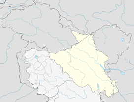 Hundar Location in Ladakh, India  Hundar Hundar (India) | |
| Coordinates: 34.575836°N 77.494823°E | |
| Country | India |
| Union Territory | Ladakh |
| District | Leh |
| Tehsil | Nubra |
| Population (2011) | |
| • Total | 1,179 |
| Time zone | UTC+5:30 (IST) |
| Census code | 928 |
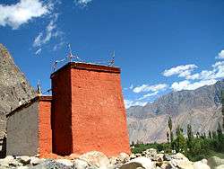
Hundar was once the capital of the former Nubra kingdom. There are several ruined buildings, including the ruins of the King's palace, the Langchen Khar ("Elephant Palace"). There is a fort at the top of the hill, called Gula. Hundar also has two Buddhist temples: the white temple (Lhakhang Karpo) and the red temple (Lhakhang Marpo).[2] Between Hundar and Diskit lie sand dunes.[3]
Demographics
According to the 2011 census of India, Hundar has 269 households. The effective literacy rate (i.e. the literacy rate of population excluding children aged 6 and below) is 60.65%.[4]
| Total | Male | Female | |
|---|---|---|---|
| Population | 1179 | 548 | 631 |
| Children aged below 6 years | 137 | 54 | 83 |
| Scheduled caste | 0 | 0 | 0 |
| Scheduled tribe | 1170 | 540 | 630 |
| Literates | 632 | 341 | 291 |
| Workers (all) | 728 | 341 | 387 |
| Main workers (total) | 267 | 169 | 98 |
| Main workers: Cultivators | 7 | 6 | 1 |
| Main workers: Agricultural labourers | 1 | 1 | 0 |
| Main workers: Household industry workers | 1 | 1 | 0 |
| Main workers: Other | 258 | 161 | 97 |
| Marginal workers (total) | 461 | 172 | 289 |
| Marginal workers: Cultivators | 410 | 143 | 267 |
| Marginal workers: Agricultural labourers | 23 | 6 | 17 |
| Marginal workers: Household industry workers | 1 | 0 | 1 |
| Marginal workers: Others | 27 | 23 | 4 |
| Non-workers | 451 | 207 | 244 |
References
- "Blockwise Village Amenity Directory" (PDF). Ladakh Autonomous Hill Development Council. Retrieved 23 July 2015.
- Prem Singh Jina (1997). Recent Researches on the Himalaya. Indus. pp. 32–. ISBN 978-81-7387-069-9.
- Max Lovell-Hoare; Sophie Lovell-Hoare (1 July 2014). Kashmir: Jammu. Kashmir Valley. Ladakh. Zanskar. Bradt Travel Guides. pp. 113–. ISBN 978-1-84162-396-2.
- "Leh district census". 2011 Census of India. Directorate of Census Operations. Retrieved 23 July 2015.
| Wikimedia Commons has media related to Hunder Village. |
| History |
| ||||||||
|---|---|---|---|---|---|---|---|---|---|
| Administration | |||||||||
| Geography |
| ||||||||
| Settlements and locations | |||||||||
| Districts | |||||||||
| Dam |
| ||||||||
| Monasteries | |||||||||
| Transport | |||||||||
| See also | |||||||||