Spanggur Tso
The Spanggur Tso (斯潘古尔湖) (lake), also called Maindung Co, Mandong Cuo (Chinese: 曼冬错) or Moldo,[1] is a saltwater lake in western Tibet Autonomous Region, China. To the west of the lake lies the Spanggur Gap, and to the north is the Pangong Tso. The lake is at an elevation of 4305 meters, and has an area of 61.6 square kilometres. The lake's average annual temperature is around -4 to -2 ℃, and the annual precipitation is 50 to 75 mm. The western portion of the lake is in the Aksai Chin region that's controlled by China but claimed by India.
| Spanggur Tso | |
|---|---|
| Mandong Cuo | |
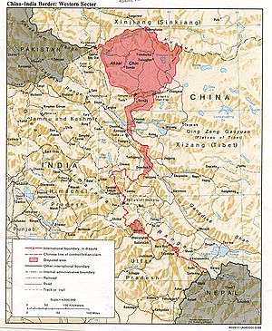 Spanggur Tso on the disputed border between China and India (CIA, 1988) | |
| Location | Rutog County, Tibet Autonomous Region, China |
| Coordinates | 33°32′11″N 78°54′32″E |
| Type | Soda lake |
| Max. length | 20.9 km (13.0 mi) |
| Max. width | Max 4.5 km (2.8 mi) average 2.95 km (1.83 mi) |
| Surface area | 61.6 km2 (23.8 sq mi) |
| Surface elevation | 4,305 metres (14,124 ft) |
Geography
The British Indian explorers in the 19th century knew the lake as Tso Rul ("Bitter Lake") and stated that its waters were extremely bitter. It was noted as being 16 miles (26 km) long and less than 2 miles (3.2 km) wide. Henry Strachey was reported to have found fossil shells of Lymnaea auricularia along its shores, leading to the conclusion that the waters of the lake must have been at one time fresh.[2]
To the northwest of the lake, there is a gap in the mountain range, which is referred to as the Spanggur Gap. The gap connects Spanggur to the Tsoka river valley running north–south and to the Ladakhi village of Chushul further west.
The first British Indian Boundary Commission of Kashmir (1847) placed the entire Spanggur lake in Rutog. The Kashmir Survey, completed in 1864, placed slightly more than half the lake in Ladakh but the eastern extremity in Rutog.[3]:71–73
Chinese administration
China established a military camp in the Spanggur area in 1959.[4]:67 During the Sino-Indian War, Chinese troops attacked and overcame four Indian posts in the area in November 1962.[4]:176
Nieghbourliness
In February 2016, the Chinese garrison at Spanggur, referred to as the "Moldo garrison" in the Indian media, conducted a joint exercise with the Chushul garrison in the interest of peace and cooperation. They coordinated rescue missions by joint teams in the event of a natural disaster occurring along the Line of Actual Control (LAC). Similar exercises were continued over the years.[1]
In June 2020, in the midst of major border skirmishes between the two countries, the tactical commanders met at Moldo to find ways of deescalation.[5]
Notes
- From map: "THE DELINEATION OF INTERNATIONAL BOUNDARIES ON THIS MAP MUST NOT BE CONSIDERED AUTHORITATIVE"
References
- Joint drill for LAC peace, The Tribune (Chandigarh), 21 July 2016.
- Cunningham, Alexander (1854), Ladak: Physical, Statistical, Historical, London: Wm. H. Allen and Co, pp. 137–138 – via archive.org
- Lamb, Alastair (1964), The China-India border, Oxford University Press
- Kavic, Lorne J. (1967). India's Quest for Security. University of California Press.
- Snehesh Alex Philip, India, China army commanders to meet tomorrow. These are the issues 14 Corps chief will raise, The Print, 5 June 2020.