Pangong Tso
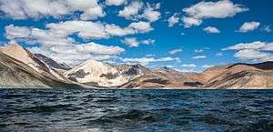
Pangong Tso or Pangong Lake (Tibetan: སྤང་གོང་མཚོ [3]; Hindi: पांगोंग त्सो; Chinese: 班公错) is an endorheic lake in the Himalayas situated at a height of about 4,350 m (14,270 ft). It is 134 km (83 mi) long and extends from India to the Tibetan Autonomous Region, China. Approximately 60% of the length of the lake lies within the Tibetan Autonomous Region. The lake is 5 km (3.1 mi) wide at its broadest point. All together it covers 604 km2. During winter the lake freezes completely, despite being saline water. It is not a part of the Indus river basin area and geographically a separate landlocked river basin.[4]
| Pangong lake | |
|---|---|
 | |
 Pangong lake  Pangong lake  Pangong lake | |
| Location | Leh Tehsil, Leh district, Ladakh, India Rutog County[1], Ngari Prefecture, Tibet Autonomous Region, China |
| Coordinates | 33°42′45″N 78°48′36″E |
| Type | Soda lake dimictic lake (east basin)[2] cold monomictic lake (west basin) |
| Basin countries | India |
| Max. length | 134 km (83 mi) |
| Max. width | 5 km (3.1 mi) |
| Surface area | approx. 700 km2 (270 sq mi) |
| Max. depth | 328 ft. (100 m) |
| Surface elevation | 4,250 metres (13,940 ft) |
| Frozen | during winter |
| Pangong Tso | |||||||||
|---|---|---|---|---|---|---|---|---|---|
| Chinese name | |||||||||
| Traditional Chinese | 班公錯 | ||||||||
| Simplified Chinese | 班公错 | ||||||||
| |||||||||
| Tibetan name | |||||||||
| Tibetan | སྤང་གོང་མཚོ | ||||||||
| |||||||||
| Tsomo Nganglha Ringpo | |||||||||
|---|---|---|---|---|---|---|---|---|---|
| Chinese name | |||||||||
| Traditional Chinese | 錯木昂拉仁波 | ||||||||
| Simplified Chinese | 錯木昂拉仁波 | ||||||||
| |||||||||
| Alternative Chinese name | |||||||||
| Simplified Chinese | 哥木克哥那喇令错 | ||||||||
| |||||||||
| Tibetan name | |||||||||
| Tibetan | མཚོ་མོ་ངང་ལྷ་རིང་པོ | ||||||||
| |||||||||
The lake is in the process of being identified under the Ramsar Convention as a wetland of international importance. This will be the first trans-boundary wetland in South Asia under the convention.
Names
Historically, the lake was treated as a string of five smaller lakes with channels connecting them, the name Pangong Tso only applied to the western most lake that is mostly in Ladakh. From west to east, these lakes were each referred to as -- Pangong Tso, Tso Nyak, the twin lakes of Rum Tso, and Nyak Tso.[5][6] The whole lake group was and is still often referred to as Tsomo Nganglha Ringpo (Tibetan: མཚོ་མོ་ངང་ལྷ་རིང་པོ [3]) in Tibetan.
There are different interpretations on the meanings of both Pangong Tso and Tsomo Nganglha Ringpo. The Ladakh government website indicates "Pangong Tso" is Tibetan meaning "high grassland lake",[7] however travel books from decades back say Pangong means "hollow".[8][9] Tsomo Nganglha Ringpo is Tibetan that is interpreted to mean various different but similar meanings -- "long, narrow, enchanted lake" by Chinese media sources,[10] "female narrow very long lake" by early European explorers,[11] and "long-necked swan lake" by other modern sources.[12][13] The lake has also been referred to as Pan-kung Hu.
Flora, fauna and geography
The eastern part of the lake is fresh, with the content of total dissolved solids at 0.68 g/L, while the western part of the lake is saline, with the salinity at 11.02 g/L.[14] The brackish water[15] of the lake has very low micro-vegetation. Guides report that there are no fish or other aquatic life on the Indian side of the lake, except for some small crustaceans. On the other hand, visitors see numerous ducks and gulls over and on the lake surface. There are some species of scrub and perennial herbs that grow in the marshes around the lake.
The lake acts as an important breeding ground for a variety of birds including a number of migratory birds. During summer, the Bar-headed goose and Brahmini ducks are commonly seen here.[16] The region around the lake supports a number of species of wildlife including the kiang and the marmot. The lake hosts large quantities of fish, especially Schizopygopsis stoliczkai[17] and Racoma labiata.[18]
Formerly, Pangong Tso had an outlet to Shyok River, a tributary of Indus River, but it was closed off due to natural damming. Two streams feed the lake from the Indian side, forming marshes and wetlands at the edges.[19] Strand lines above current lake level reveal a 5 m (16 ft) thick layer of mud and laminated sand, suggesting the lake has shrunken recently in geological scale.[15] On the Indian side, no fish have been observed, however in the stream coming from South-eastern side (Cheshul nalla), three fish species (Schizopygopsis stoliczkae, Tibetan stone loach and Triplophysa gracilis) have been reported (Bhat et al., 2011). The low biodiversity has been reported as being due to high salinity and harsh environmental conditions (Bhat et al., 2011).
Bird Islet is the most famous island in Pangong Tso.[1]
Climate
| Climate data for Pangong Tso | |||||||||||||
|---|---|---|---|---|---|---|---|---|---|---|---|---|---|
| Month | Jan | Feb | Mar | Apr | May | Jun | Jul | Aug | Sep | Oct | Nov | Dec | Year |
| Average high °C (°F) | −5.9 (21.4) |
−3.7 (25.3) |
0.9 (33.6) |
6.9 (44.4) |
11.6 (52.9) |
17.4 (63.3) |
20.5 (68.9) |
19.7 (67.5) |
15.5 (59.9) |
7.9 (46.2) |
1.5 (34.7) |
−3.3 (26.1) |
7.4 (45.4) |
| Daily mean °C (°F) | −13.3 (8.1) |
−10.8 (12.6) |
−6.0 (21.2) |
−0.5 (31.1) |
3.8 (38.8) |
9.5 (49.1) |
13.1 (55.6) |
12.7 (54.9) |
7.8 (46.0) |
−0.3 (31.5) |
−6.8 (19.8) |
−11.3 (11.7) |
−0.2 (31.7) |
| Average low °C (°F) | −20.6 (−5.1) |
−17.9 (−0.2) |
−12.8 (9.0) |
−7.8 (18.0) |
−3.9 (25.0) |
1.6 (34.9) |
5.8 (42.4) |
5.7 (42.3) |
0.2 (32.4) |
−8.5 (16.7) |
−15.1 (4.8) |
−19.3 (−2.7) |
−7.7 (18.1) |
| Average precipitation mm (inches) | 4 (0.2) |
2 (0.1) |
3 (0.1) |
3 (0.1) |
4 (0.2) |
2 (0.1) |
11 (0.4) |
15 (0.6) |
4 (0.2) |
2 (0.1) |
2 (0.1) |
3 (0.1) |
55 (2.3) |
| Source: Climate-Data.org | |||||||||||||
Access

An Inner Line Permit is required to visit the lake as it lies on the Sino-Indian Line of Actual Control. While Indian nationals can obtain individual permits, others must have group permits (with a minimum of three persons) accompanied by an accredited guide; the tourist office in Leh issues the permits for a small fee. For security reasons, India does not permit boating.
China National Highway 219 passes by the eastern end of Pangong Tso. The lake can be accessed by driving 12 km from Rutog or 130 km from Shiquanhe. Tourists can rent a boat on the lake, but landing on islands is not allowed for protecting the breeding ground of the birds. There are several restaurants along the shore.[20]
Sino-Indian border dispute
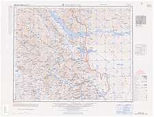
 |
with "fingers" – mountain spurs jutting into the lake[22] |
Pangong Tso is in disputed territory. The Line of Actual Control passes through the lake. A section of the lake approximately 20 km east from the Line of Actual Control is controlled by China but claimed by India. The eastern end of the lake is in Tibet, China. After the mid-19th century, Pangong Tso was at the southern end of Johnson Line, an early attempt at demarcation between India and China in the Aksai Chin region.
The Khurnak Fort lies on the northern bank of the lake, halfway of Pangong Tso.[23] The Chinese has controlled the Khurnak Fort area since 1952.[24][25] To the south is the smaller Spanggur Tso lake.
On 20 October 1962, Pangong Tso saw military action during the Sino-Indian War, successful for the Communist People's Liberation Army.[26]
Pangong Tso is still a delicate border point along the Line of Actual Control.[27][28] Incursions from the Chinese side are common.[29]
In August 2017, Indian and Chinese forces near Pangong Tso threw rocks at each other.[30][31][32]
On September 11, 2019, People's Liberation Army troops confronted Indian troops on the northern bank of Pangong Lake.[33][34]
On May 5-6, 2020, there was a face-off between about 250 Indian and Chinese troops near Pangong Tso lake.[35][31] [36] [37][38] Four Indian and seven Chinese soldiers were injured.[39]
Pollution
As tourism grows in Ladakh and Pangong Lake, the ecologically fragile area is getting swamped with trash.[40] Authorities are trying to put a mechanism in place to manage the waste generated by restaurants, hotels, and camping sites. Tourists often dump disposable water bottles and food packets right at the periphery of the lake and even inside. This is posing a big threat to this glacial lake.
 Tourists dump plastic bottles at Pangong Lake
 Plastic bottles at Pangong Lake
 Plastic bottle dumped in Pangong Lake
In film
- Indian filmmaker Mani Ratnam's Dil Se.. (1998) in the song "Satrangi Re" starring Shah Rukh Khan & Manisha Koirala.
- Featured as a filming location in The Fall (2006).
- Some parts of the 2008 film, Heroes (2008).
- Climax scene of the 2009 film, 3 Idiots.
- Parts of the 2012 film Jab Tak Hai Jaan, in particular, Anushka Sharma's bikini scene were shot here. This was Actor Shah Rukh Khan's second film recorded here.
- Divya Khosla Kumar 2016 Hindi film Sanam Re[41]
- Surra Surra song from Shakti (2011).
- Subah Hogee song from Waqt: The Race Against Time.
- Pyar Ke Silsile song from Na Jaane Kabse (2011).
- Dil Tera Ho Gaya song from Taur Mittran Di.
- Dil Haara song from Tashan starring Saif Ali Khan & Kareena Kapoor
- Banjarey song from the movie Fugly
- Bhelpuri song from Aagadu starring Mahesh Babu & Tamannaah
- Enna Aachu song in the 2011 Tamil movie Vedi
Gallery

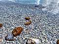 Pangong Lake Transparent Water & Pebbles
 View of Pangong Tso from west side with beautiful Yak
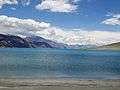 Pangong Tso Blue water
 Pangong lake on 21 July 2018
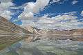 The lake during summer
 Ducks as seen in the Lake
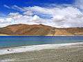 The lake during summer
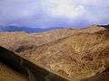 Road to Pangong Tso
 Road to Pangong Tso
 Pangong Tso in April
 pangong Tso wide
 Pangong Tso brackish water
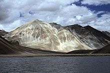 Pangong Tso
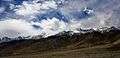 Hills on the south-west bank of Pangong Tso
See also
- Aksai Chin
- Tso Moriri
- Chumar
- Chepzi
- Rudok
- National Large Solar Telescope, one of the world largest solar telescope proposed to be built near Pangong Tso
- Soda lake
- List of locations in Aksai Chin
- Sirijap
- Changtang
Notes
- From map: "THE DELINEATION OF INTERNATIONAL BOUNDARIES ON THIS MAP MUST NOT BE CONSIDERED AUTHORITATIVE"
References
- Dreams of Snow Land. Beijing: Foreign Languages Press. 2005. pp. 273-275. ISBN 7-119-03883-4 – via Internet Archive.
- Wang, M., Hou, J. and Lei, Y., 2014. Classification of Tibetan lakes based on variations in seasonal lake water temperature. Chinese Science Bulletin, 59(34): 4847-4855.
- "Ngari prefecture". Geographical names of Tibet AR (China). Institute of the Estonian Language. 3 June 2018. Retrieved 9 January 2020.
- "River basins with Major and medium dams & barrages location map in India, WRIS". Archived from the original on 4 March 2016. Retrieved 10 May 2014.
- Sven Anders Hedin (1907). Scientific Results of a Journey in Central Asia 1899-1902: Central and West Tibet. Lithographic institute of the General staff of the Swedish army. p. 521.
From Noh to Bal Rawling followed the same route that I did along the northern shore of the Tso-ngombo, which he calls the Tso Mo Gualari, dividing it into the sections ›Tso Nyak, the twin lakes Rum Tso and Nyak Tso.› He says that it consists of a string of five lakes 120 m. in length, the four most southern of which are fresh, and Pangong, the most northerly, salt. They are joined together by channels about 60 feet in width and 15 feet deep, the current running at nearly 1½ mile an hour.
- Routes in Asia: Routes in the territories of the Maharaja of Jummoo and Kashmir, and adjacent countries. Office of the Superintendent of Government Printing. 1878. pp. 31–33.
Only the lower lake (the Pangong Tso proper) lies in Ladak, the middle (Tso Nyak) and upper lakes being in Rudok territory. ... The waters of the western end are much more salt than those of the eastern end near Ot. in the stream connecting the Pangong Tso with Nyak Tso the water becomes drinkable, and rich grass is found on the banks.
- "Pangong Lake". Union Territory of Ladakh. 29 October 2019. Retrieved 9 January 2020.
Pangong Lake, one of the most famous lakes in Leh Ladakh, derives its name from the Tibetan word, “Pangong Tso”, which means “high grassland lake”.
- Michelle Coxall; Paul Greenway (1 September 1996). Indian Himalaya: a Lonely Planet travel survival kit. Lonely Planet. ISBN 978-0-86442-413-6.
The salty Pangong Tso - Pangong means 'hollow' - is the highest lake in Ladakh at about 4300m, and is flanked by massive peaks over 6500m high.
- Kirit Rindani (7 January 2016). Indian Himalaya: Story of a 100 Visits. Partridge Publishing India. p. 80. ISBN 978-1-4828-5886-0.
The word Pangong means 'extensive concavity' which probably explains its size.
- "Pangong Tso Lake in Tibet". China Daily. 17 July 2012. Retrieved 9 January 2020.
Pangong Tso Lake is a trans-border lake extending from the Ali prefecture of China's Tibet autonomous region to India. About 155 kilometers in length, the geographic features of the lake are indicated in the name which in Tibetan means "long, narrow, enchanted lake".
- Trotter, H. (1877). "Account of the Pundit's Journey in Great Tibet from Leh in Ladakh to Lhasa, and of His Return to India Via Assam". Journal of the Royal Geographical Society of London. 47: 86. doi:10.2307/1798740. ISSN 0266-6235. JSTOR 1798740.
the Pangong, but better known to the Tibetans as the Chomo Gna Laring Cho, which, being literally interpreted, means "Female narrow very long lake."
- "Pangong Tso Lake in the Northern Tibet". Kangba TV. 6 March 2017. Retrieved 9 January 2020.
Pangong Tso Lake, at an altitude of 4,200 meters, is also called Tsomo Nganglha Ringpo Lake, which means “a swan with a long neck” in Tibetan.
- "Pangong Lake". Tibet Vista (Tibettravel.org). Archived from the original on 28 April 2015. Retrieved 9 January 2020.
In the Tibetan language, this lake is called “Cuomu Angla Renbo Tso”, which means “Long-Necked Crane Lake”.
- "班公错" (in Chinese).
- R. K. Pant; N. R. Phadtare; L. S. Chamyal; Navin Juyal (June 2005). "Quaternary deposits in Ladakh and Karakoram Himalaya: A treasure trove of the palaeoclimate records" (PDF). Retrieved 29 January 2019. Cite journal requires
|journal=(help) - Khan, Asif (2016). "Ladakh: The Land Beyond". Buceros. Vol.21, Issue 3: 6–15.
- "Schizopygopsis stoliczkae". China Animal Scientific Database. Archived from the original on 5 March 2016. Retrieved 22 September 2018.
- "Racoma labiata". China Animal Scientific Database. Archived from the original on 5 March 2016. Retrieved 22 September 2018.
- Biksham Gujja; Archana Chatterjee; Parikshit Gautam & Pankaj Chandan (August 2003). "Wetlands and Lakes at the Top of the World". Mountain Research and Development. Bern, Switzerland: International Mountain Society. 23 (3): 219–221. doi:10.1659/0276-4741(2003)023[0219:WALATT]2.0.CO;2. ISSN 1994-7151.
- 黄慧英 (4 August 2018). "一措再措 邂逅高原湖泊的绝美" (in Chinese). tibet.cn. Retrieved 22 September 2018.
-
India, Ministry of External Affairs, ed. (1962), Report of the Officials of the Governments of India and the People's Republic of China on the Boundary Question, Government of India Press, Chinese Report, Part 1, pp. 4–5
The location and terrain features of this traditional customary boundary line are now described as follows in three sectors, western, middle and eastern. ... From Ane Pass southwards, the boundary line runs along the mountain ridge and passes through peak 6,127 (approximately 78° 46' E, 38° 50' N) [sic] and then southwards to the northern bank of the Pangong Lake' (approximately 78° 49' E, 33° 44' N). It crosses this lake and reaches its southern bank at approximately 78° 43' E, 33° 40' N. Then it goes in a south-easterly direction along the watershed dividing the Tongada River and the streams flowing into the Spanggur Lake until it reaches Mount Sajum. - Lt Gen H. S. Panag, India’s Fingers have come under Chinese boots. Denial won’t help us, The Print, 4 June 2020.
- Negi, S.S. (1 April 2002). Himalayan Rivers, Lakes and Glaciers. India: Indus Publishing Company. p. 152. ISBN 978-8185182612. Retrieved 12 September 2009.
- Guruswamy, Mohan (January 2006). Emerging Trends in India-China Relations. India: Hope India Publications. p. 223. ISBN 9788178711010. Retrieved 12 September 2009.
- Mohan Guruswamy. "No longer a Great Game". Centre for Policy Alternatives, India. Archived from the original on 16 October 2007.
- Burkitt, Laurie; Scobell, Andrew; Wortzel, Larry M. (July 2003). The Lessons of History: The Chinese People's Liberation Army at 75 (PDF). Strategic Studies Institute. pp. 340–341. ISBN 1-58487-126-1.
- Manu Pubby. "Pangong Lake is border flashpoint between India and China". New Delhi, India: The Indian Express Limited. Retrieved 24 June 2009.
- Sultan Shahin. "Vajpayee claps with one hand on border dispute". Retrieved 24 June 2009.
- Jonathan Holslag (2008). "China, India and the Military Security Dilemma, Vol 3(5)" (PDF). Brussels Institute of Contemporary China Studies (BICCS). Archived from the original (PDF) on 6 June 2011. Retrieved 24 June 2009. Cite journal requires
|journal=(help) - 中共與印度邊境衝突!150士兵互毆10多人掛彩. New Tang Dynasty Television (in Chinese). 11 May 2020. Retrieved 16 May 2020.
- 費風 (11 May 2020). 中印邊境再爆衝突 150士兵毆鬥釀12傷. Hong Kong Economic Times (in Chinese). Retrieved 16 May 2020.
消息指,第一起事件發生於5月5日至6日,在中印邊境的班公錯湖(Pangong Tso )地區,當時解放軍的「侵略性巡邏」(aggressive patrolling)被印度軍方阻攔。「結果發生了混亂,雙方都有一些士兵受傷。」{...}2017年8月,兩國軍隊曾於拉達克地區班公湖附近爆發衝突,當時雙方擲石攻擊對方,雙方均有人受傷,最終兩軍在半小時後退回各自據點。
- Sushant Singh (20 May 2020). "India-China conflict in Ladakh: The importance of the Pangong Tso lake". The Indian Express. Retrieved 21 May 2020.
- "Indian, Chinese Troops Face-off in Ladakh Ahead of Modi-Xi Summit, Army Says Tension De-escalated". CNN-News18. 12 September 2019. Retrieved 12 May 2020.
- Chang Ya-Han 張雅涵, ed. (10 March 2020). 中國在西藏地區軍演頻繁 牽動中印未來危機應對. Radio Taiwan International (in Chinese). Retrieved 16 May 2020.
- Dinakar Peri (10 May 2020). "Indian, Chinese troops face off in Eastern Ladakh, Sikkim". The Hindu. Retrieved 13 May 2020.
- "India's access to China border now, 120 feet long bridge ready in six days".
- "Chinese military bolsters troops in Aksai Chin region in Sino-India border: Report". The Economic Times. 19 May 2020. Retrieved 19 May 2020.
On May 5, around 250 Indian and Chinese army personnel clashed in Pangong Tso lake area in Eastern Ladakh.
- "Chinese, Indian troops engage in border conflicts". Taiwan News. 25 May 2020. Retrieved 26 May 2020.
- 'All-out combat' feared as India, China engage in border standoff
- "As tourism grows, so does trash in Ladakh's Pangong Lake".
- "BT Exclusive: First look of Divya Khosla Kumar's 'Sanam Re'".
Further reading
- SINO-INDIAN BORDER DEFENSES CHUSHUL AREA (CIA, 1963)
- India China LAC tension
| Wikimedia Commons has media related to Pangong Tso. |
| History |
| ||||||||
|---|---|---|---|---|---|---|---|---|---|
| Administration | |||||||||
| Geography |
| ||||||||
| Settlements and locations | |||||||||
| Districts | |||||||||
| Dam |
| ||||||||
| Monasteries | |||||||||
| Transport | |||||||||
| See also | |||||||||