Chumathang
Chumathang is a village in Leh District, Ladakh in northern India on the banks of the Indus river.
Chumathang | |
|---|---|
Village | |
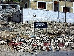 Chumathang dhaba and sign | |
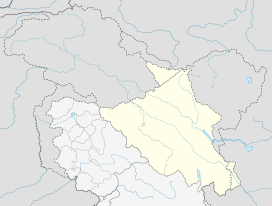 Chumathang Location in Ladakh, India  Chumathang Chumathang (India) | |
| Coordinates: 33.36°N 78.34°E | |
| Country | India |
| Union Territory | Ladakh |
| District | Leh |
| Tehsil | Nyoma |
| Elevation | 3,950 m (12,960 ft) |
| Population (2011) | |
| • Total | 641 |
| Languages | |
| • Official | Ladakhi, Boti |
| Time zone | UTC+5:30 (IST) |
| PIN | 194201 |
| Census code | 900 |
It is 138 km (86 miles) southeast of Leh.,[1] and 41 km northwest of Nyoma,[2] and 29 km (18 miles) from Kiari, where there is a small medical centre run by the Indian Army.[3] It lies on the banks of Indus River. Chumathang also offers Himalayan homestays which are suitable for those who like to live and take a little peek in a local Ladakhi house and stay there for a day or two.
There are a few small dhabas or restaurants here making it a good spot to lunch and visit the hot springs which are about 2 km to the east. There is also a basic guesthouse and small store in the village.[4] Near the hot springs is the Hot Spring Resort which has 4 basic rooms - one with a hot bath.
Travellers coming from the south will find that Chumathang is significantly lower than the Tso Moriri lake, making it a good stop for people suffering from altitude sickness.
Gompa
Behind and above the village is a small village gompa or monastery.
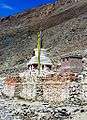 Chumathang chorten
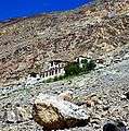 Chumathang gompa
Demographics
According to the 2011 census of India, Chumathang has 127 households. The effective literacy rate (i.e. the literacy rate of population excluding children aged 6 and below) is 68.03%.[5]
| Total | Male | Female | |
|---|---|---|---|
| Population | 641 | 237 | 404 |
| Children aged below 6 years | 56 | 29 | 27 |
| Scheduled caste | 0 | 0 | 0 |
| Scheduled tribe | 635 | 231 | 404 |
| Literates | 398 | 159 | 239 |
| Workers (all) | 222 | 106 | 116 |
| Main workers (total) | 132 | 97 | 35 |
| Main workers: Cultivators | 72 | 56 | 16 |
| Main workers: Agricultural labourers | 0 | 0 | 0 |
| Main workers: Household industry workers | 4 | 1 | 3 |
| Main workers: Other | 56 | 40 | 16 |
| Marginal workers (total) | 90 | 9 | 81 |
| Marginal workers: Cultivators | 74 | 2 | 72 |
| Marginal workers: Agricultural labourers | 0 | 0 | 0 |
| Marginal workers: Household industry workers | 0 | 0 | 0 |
| Marginal workers: Others | 16 | 7 | 9 |
| Non-workers | 419 | 131 | 288 |
External links
References
- Ladakh, The Essential Guide with Kashmir and Kulu-Manali. Second Edition 2010. Partha S. Banarjee. Milestone Books, Calcutta, p. 183
- "Leh district census". 2011 Census of India. Directorate of Census Operations. Retrieved 23 July 2015.
| History |
| ||||||||
|---|---|---|---|---|---|---|---|---|---|
| Administration | |||||||||
| Geography |
| ||||||||
| Settlements and locations | |||||||||
| Districts | |||||||||
| Dam |
| ||||||||
| Monasteries | |||||||||
| Transport | |||||||||
| See also | |||||||||