Padum
Padum is named after Padmasambhava. It is the only town and administrative centre in Zanskar. It was historically one of the two main capitals of the Zanskar Kingdom, the other being Zangla. It is 240 km away via the link road from Kargil town (National Highway No. 01D).
Padum | |
|---|---|
Town | |
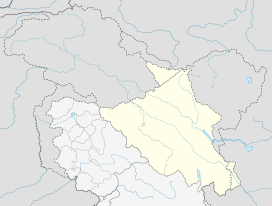 Padum Location in Ladakh, India  Padum Padum (India) | |
| Coordinates: 33°27′50″N 76°52′43″E | |
| Country | |
| Union Territory | Ladakh |
| District | Kargil |
| Tehsil | Zanskar |
| Government | |
| • Type | Autonomous Hill Development Council |
| • Body | LAHDC, Kargil |
| Elevation | 3,669 m (12,037 ft) |
| Population (2012) | |
| • Total | 25,000 |
| Languages | |
| • Official | English Tibetan Hindi Urdu |
| Time zone | UTC+5:30 (IST) |
| Vehicle registration | JK 07 XXXX |
| Website | http://www.kargil.nic.in/ |
Description
The population of Padum is about 13,459 people.[1] The traditional heart of the village is below the gompa and Palace khar (now in ruins) where two large chortens stand above old buildings. A road was constructed in 1980 from NH1, Kargil over Pensi La while the road to Darcha is yet half way through. Padum has several hotels, homestays and restaurants meant for tourists. Padum has a post office, internet cafes and telephone booths.
Geography
Padum is at the centre of the tri armed Zanskar valley.[2] It has an average elevation of 3,657 metres (11,998 feet). There are several villages to the north-east of Padum leading to Karsha monastery.
People
Padum is largely inhabited by people of Tibetan descent who follow Tibetan Buddhism, but there is a sizable Muslim minority (accounting for ~40% of the town's population), mainly Balti, who have been present in Padum since the 17th century.
Town

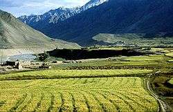

The sub-divisional capital Padum is a town of the Zanskar sub-division or tehsil in the Kargil district of Ladakh state, India. The Zanskar River flows through the valley from its source at the Drang Drung glacier of the Pensi La.The Zanskar River joins the Lungnak River near Pibiting village.
A number of notable Buddhist monasteries are located near Padum including Bardan Monastery and Kursha Monastery and the newly built Dalai Lama Photang. The Phugtal Monastery is accessible from here. It is a day's trek from Dorzang, the end of the road leading from Padum.[3]
Access
By Bus: The bus details here apply during the tourist season between 1 July and 15 September only, after this period the Manali-Leh NH21 highway is formally closed. The other roads including the highway from Leh to Srinagar via Kargil, remain open until the end of October. Despite heavy blizzards, the road from Leh to Nubra valley over the extremely high Khardung La is kept open throughout the year.
Footnotes
- Osada et al (2000), p. 298.
- Osada et al (2000), p. 298.
- "Phugtal Monastery". Archived from the original on 19 November 2015. Retrieved 19 November 2015.
References
- Janet Rizvi. (1996). Ladakh: Crossroads of High Asia. Second Edition. Oxford University Press, Delhi. ISBN 0-19-564546-4.
- Osada et al. (2000). Mapping the Tibetan World. Yukiyasu Osada, Gavin Allwright, and Atsushi Kanamaru. Reprint: 2004. Kotan Publishing, Tokyo. ISBN 0-9701716-0-9.
- Schettler, Margaret & Rolf (1981). Kashmir, Ladakh & Zanskar. Lonely Planet Publications. South Yarra, Victoria, Australia. ISBN 0-908086-21-0.
External links
| History |
| ||||||||
|---|---|---|---|---|---|---|---|---|---|
| Administration | |||||||||
| Geography |
| ||||||||
| Settlements and locations | |||||||||
| Districts | |||||||||
| Dam |
| ||||||||
| Monasteries | |||||||||
| Transport | |||||||||
| See also | |||||||||