Dras River
The Dras River, also spelt Drass River , is a river in the Kargil district in the Indian union territory of Ladakh.
| Dras River | |
|---|---|
 Dras River | |
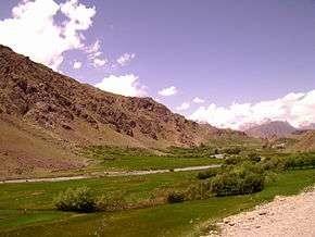
 The confluence of the Dras River with the Suru River | |
| Location | |
| Country | India |
| Union Territory | Ladakh |
| District | Kargil |
| Physical characteristics | |
| Source | 34.272303°N 75.529832°E |
| ⁃ location | Machoi Glacier near Zojila |
| ⁃ elevation | 4,400 m (14,400 ft) |
| Mouth | 34.5946°N 76.1202°E |
⁃ location | Suru River at Kharul Kargil |
⁃ elevation | 3,618 m (11,870 ft) |
| Length | 86 km (53 mi) |
| Discharge | |
| ⁃ average | 212 m3/s (7,500 cu ft/s) |
Course
The Dras River is 86 km (53 mi) long and flows entirely in the Dras Valley. Its source lies in the Machoi Glacier near Zojila Pass, the gateway to Ladakh, 26 km (16 mi) east of Sonamarg and 120 km (75 mi) east of Srinagar, the capital of Jammu and Kashmir.[1][2] The Machoi Glacier is also the source of the Sind River, which flows through the neighbouring Kashmir Valley in the opposite direction to the Dras River.[3] The Dras River flows northeast, fed by many glacial streams. NH 1D, a national highway connecting Srinagar with Ladakh (Kargil and Leh), runs parallel to the river. The river forms the Dras Valley at Dras,[2] where it is joined by two tributaries, the Mashko Nala and Gamru Nala, which originate in the glaciers of Mashko Valley.[3] In the Dras Valley, the road connecting Dras and Gurais runs parallel to the river.

The Shingo River joins the Dras River at Kharbu, and doubles the flow of the river. The Shingo River originates in the Chota Deosai Plains north of Minimarg (Astore District, Gilgit-Baltistan) and flows east.[4][2]
The combined Dras and Shingo rivers join the Suru River at Kharul, 7 km (4.3 mi) north of the town of Kargil.[2] The Suru River is a left tributary of the Indus River.[5] It originates from the Panzella glacier near Pensi La, flows northwards and merges with the Indus River at Nurla in Pakistan-administered Gilgit-Baltistan, 5 km (3.1 mi) north of its confluence with the Dras River. It enters the Pakistani-Administered Kashmir at Post 43 of India or Post 44 of Pakistan.[6]
Habitation
The Dras River flows through the towns of Matayan, Kharbu and Kakshar. The largest settlement on its banks is Dras, which is the second-coldest inhabited place in the world after Siberia.[7] The water flow of the river increases during the late summer, due to the heavy melting of glaciers.[8]
See also
References
- "Kargil the Suru valley". gaffarkashmir.com. Archived from the original on 19 April 2019. Retrieved 29 August 2012.
- Omacanda Hāṇḍā (2001). Buddhist Western Himalaya: A politico-religious history. Indus Publishing, 2001. p. -67. ISBN 9788173871245. Retrieved 27 August 2012.
- Harish Kapadia (1999). Across Peaks & Passes in Ladakh, Zanskar & East Karakoram. Indus Publishing, 1999. p. -226. ISBN 9788173871009. Retrieved 27 August 2012.
- Kapadia, Harish (1999), Across Peaks & Passes in Ladakh, Zanskar & East Karakoram, Indus Publishing, pp. 226–, ISBN 978-81-7387-100-9
- S. S. Negi (2002). Cold Deserts of India. Indus Publishing, 2002. p. -13. ISBN 9788173871276. Retrieved 27 August 2012.
- "Rivers of Ladakh". ladakh.com. Archived from the original on 2 September 2012. Retrieved 29 August 2012.
- M.S. Kohli (2004). Mountains of India: Tourism, Adventure, Pilgrimage. Indus Publishing, 2004. p. -124. ISBN 9788173871351. Retrieved 29 August 2012.
- Sharad Singh Negi (1991). Himalayan Rivers, Lakes, and Glaciers Informative books on the himalayas-forestry-environment. Indus Publishing, 1991. p. -61. ISBN 9788185182612. Retrieved 27 August 2012.
Further reading
- William Moorcroft; George Trebeck; Horace Hayman Wilson (1841). Travels in the Himalayan Provinces of Hindustan and the Panjab; in Ladakh and Kashmir; in Peshawar, Kabul, Kunduz, and Bokhara ...: From 1819 to 1825, Volume 2. J. Murray, 1841. p. -261–265. Retrieved 27 August 2012.
Shingo river.
External links
| Wikimedia Commons has media related to Dras River. |
- Suru River basin on OpenStreetMap, including the Dras River
| History |
| ||||||||
|---|---|---|---|---|---|---|---|---|---|
| Administration | |||||||||
| Geography |
| ||||||||
| Settlements and locations | |||||||||
| Districts | |||||||||
| Dam |
| ||||||||
| Monasteries | |||||||||
| Transport | |||||||||
| See also | |||||||||