Kargil district
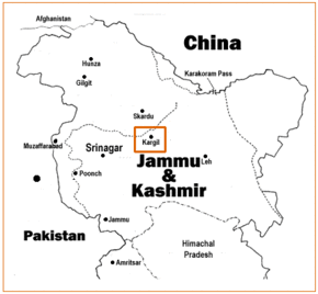
Kargil district is a district in the union territory of Ladakh in northern India. It spans the entire length of Ladakh in the north–south direction, with Jammu and Kashmir to the west, the Leh district to the east, the Pakistan-administered region of Gilgit–Baltistan to the north and Himachal Pradesh to the south. Encompassing two historical regions known as Purig and Zanskar, the district lies to the northwest of the Great Himalayan range and encompasses the majority of the Zanskar Range. Its population inhabits the river valleys of the Dras, Suru, Kartse, Wakha, and Zanskar rivers.
Kargil district | |
|---|---|
District of Ladakh | |
.svg.png) Location of Kargil district within Ladakh and the wider Kashmir region | |
| Country | |
| Union territory | Ladakh |
| Established | July 1979 |
| Headquarters | Kargil |
| Tehsils | Drass, Kargil, Shargole, Shakar-Chiktan, Sankoo, Taisuru and Zanskar |
| Government | |
| • Deputy Commissioner | Baseer-ul-Haq Choudhary |
| • Chief Executive Councillor | Feroz Ahmed Khan |
| • Lok Sabha constituencies | Ladakh |
| Area | |
| • Total | 14,086 km2 (5,439 sq mi) |
| Population (2011) | |
| • Total | 140,802 |
| • Density | 10.0/km2 (26/sq mi) |
| • Urban | 16,338 |
| Demographics | |
| • Literacy | 71.34% |
| • Sex ratio | 810 |
| Time zone | UTC+05:30 (IST) |
| Website | http://kargil.nic.in/ |
The district was created in 1979 by carving it out of the Leh district.[1] In 2003, Kargil was granted a Ladakh Autonomous Hill Development Council (LAHDC).
As of 2011, the Kargil district population is 77% Muslim, of which 65% follow Shia Islam. Buddhism and Hinduism represent 14.5% and 8% of the local population respectively.[2]
In August 2019 the Parliament of India passed an act that contains provisions to make Kargil a district of the new union territory of Ladakh which was formed on 31 October 2019.[3] The town of Kargil is designated as a joint capital of the union territory, along with Leh.
Etymology
The name Kargil is said to derive from the words Khar, meaning castle, and rKil meaning "centre". "Kargil denotes a place between many forts, a central place where people could stay". It appears to be a fitting description for a place that is equidistant from Srinagar, Leh and Skardu (the capitals of the Kashmir Valley, Ladakh and Baltistan respectively).[4]
Historically, the region around Kargil was called Purig.[5] A major study of the history of Purig is included in the 1987 book Qadeem Ladakh by Kacho Sikander Khan, which includes genealogies of various dynasties that ruled the region.[6]
The southern part of the Kargil district, Zanskar was historically a separate Buddhist kingdom. It was integrated with Kargil and Ladakh only after the Dogra conquest in the 19th century.
History
Starting in 1590, the Gyalpo (king) of Leh, Sengge Namgyal (Sen-ge-rnam-rgyal), extended his control over Western Tibet. Between 1640–1675, Purig came under the control of his grandson Deldan Namgyal? (Bde-ldan-rnam-rgyal), along with Zanskar and other parts of the modern Ladakh Division.[7]
Princely State of Jammu and Kashmir
In 1822, Raja Gulab Singh of the Dogra dynasty was anointed as the Raja of Jammu by the Sikh emperor Ranjit Singh. In 1834, Gulab Singh sent his general Zorawar Singh Kahluria to conquer the territory between Jammu and the Tibetan border. Marching through Kishtwar, Zorawar Singh reached Purig and defeated the Bhotia leader Mangal at Sankoo in August. Kartse, the then capital of Purig, fell into Zorawar Singh's hands, who built a fort there before advancing towards Leh. Tshed-Pal, the Gyalpo of Leh, was defeated and reinstalled as a subsidiary of the Dogras. Meanwhile, the chief of Sod rebelled and Zorawar Singh returned to reassert his authority. Zanskar offered submission subsequently.[8][9]
The Ladakhis rebelled repeatedly, instigated by the Sikh governor Mihan Singh of Kashmir. They also received support from Ahmed Shah of Baltistan. Zorawar Singh returned in 1839 to quell the rebellion and conquered Baltistan as well.[10][11]
Following the First Anglo-Sikh War and the Treaty of Amritsar (1846), Gulab Singh was made an independent Maharaja of Jammu and Kashmir.[12] The princely state of Jammu and Kashmir, as it eventually came to be called, was organised into two large provinces, Jammu and Kashmir, and two frontier ilaqas, Ladakh and Gilgit.[13]
Ladakh was a wazarat (district) with a governor called wazir-e-wazarat. It had three tehsils: Leh, Kargil and Skardu. Initially, the Wazir used to spend four months each at Leh, Kargil and Skardu. But shifting the entire staff so often proved too exhausting and, so, the shifting was eventually limited to Leh and Skardu. The city of Kargil always had a tehsil headquarters. It was a key centre, being equidistant from Srinagar, Leh and Skardu. Zanskar, which was once part of the Kishtwar district was merged into the Kargil tehsil.[14]
Post 1947
During the Indo-Pakistani War of 1947, there were pitched battles fought around Kargil which saw the entire area including Drass and Zoji La Pass initially coming under Pakistan control before most of it being reclaimed by Indian troops by November 1948.[15] It remained with India after the ceasefire. It again saw some action in the Second Kashmir War with India managing to wrest back the remainder of the Kargil area twice. The first capture was on 17 May 1965, when skirmishes broke out in Rann of Kutch, and India retaliated in the Kashmir sector.[15]
However, this had to be returned as per UNMOGIP treatise. On 15 August, the same year Kargil fell to Indian forces, though it was once again returned as part of the Tashkent Agreement.[15] However, in the Indo-Pakistani War of 1971 the entire Kargil region including key posts was captured by Indian troops under leadership of Col. Chewang Rinchen .[16]
To straighten the line of control in the area, the Indian Army launched night attacks when the ground temperatures sank to below −17 °C and about 15 enemy posts located at height of 16,000 feet and more were captured.[17] After Pakistan forces lost the war and agreed to the Shimla Agreement, Kargil and other strategic areas nearby remained with India.[18] Kargil became a separate district in the Ladakh region during the year 1979 when it was bifurcated from the Leh district.
In the spring of 1999, under a covert plan of the then Army Chief Pervez Musharraf, armed infiltrators from Pakistan, aided by the Pakistani army, occupied vacant high posts in the Kargil and Drass regions. The result was a limited scale conflict (Kargil War) between the two nuclear equipped nations that ended with India regaining the Kargil region through military power and diplomatic pressure.
In August 2019 the Parliament of India passed an act that contains provisions to make Kargil a district of the new union territory of Ladakh which is to be formed on 31 October 2019.[3]
Geography
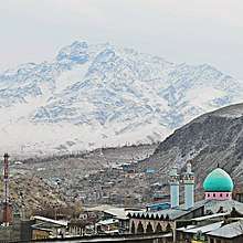
Kargil district is nestled in the Himalayas, giving it a cool, temperate climate. Summers are warm with cool nights, while winters are long and cold with temperatures often dropping to −15 °C (5 °F) with recorded temperatures of −60 °C (−76 °F) in the tiny town of Dras, situated 56 km (35 mi) from the Kargil town. The Zanskar Valley is colder. Kargil district is spread over 14,086 km2 (5,439 sq mi). The Suru River flows through the district.
National Highway 1D, connecting Srinagar to Leh, passes through Kargil. This highway is typically open for traffic only from May to December due to heavy snowfall at the Zoji La. Kargil is 204 km (127 mi) from the capital city of Srinagar. There is a partially paved road leading from Kargil south to Zanskar. Total distance to Zanskar is nearly 220 km (140 mi), which is again open only from June to September. Both India and Pakistan have considered linking the Pakistani town of Skardu to Kargil via a bus route to facilitate free movement of Kashmiris in the area.[19]
Demographics
According to the 2011 census Kargil district has a population of 140,802.[20] This gives it a ranking of 603rd in India (out of a total of 640). The district has a population density of 10 inhabitants per square kilometre (26/sq mi). Its population growth rate over the decade 2001-2011 was 20.18%. Kargil has a sex ratio of 810 females per every 1000 males, and a literacy rate of 71.34%.
Religion
Of the total population, 73% are Muslims, of which 63% follow Shia Islam. Most of the district's Muslims are found in the north (Kargil town, Drass, and the lower Suru valley). Of the remainder, 17% of the total population practises Tibetan Buddhism and Bön, mostly found in Zanskar with small populations in the upper Suru valley (Rangdum) and around Shergol and Mulbekh. Remaining 8% of the native population follow Hinduism and Sikhism.
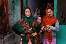
Much of Kargil population is inhabited by the Purigpa and Balti people of Tibetan origin (converting from Buddhism to Islam in the 16th Century) and have intermingled with the Dard, Mon and other Aryan people.[21] The mainly Muslim Dards inhabit the valley of Drass and speak Shina, a small number of Buddhist Dards, known as Brokpa, inhabit the Dha-Hanu region along the Indus River. Some Arghons and Shina are also settled in Kargil Town.
Languages

The Balti-Purgi language is spoken by about 78 percent population of Kargil while 10 percent speak Dardic Shina language. Balti is a dialect of Tibetan and is spoken by the inhabitants of Askardu (Baltistan) and Turtuk in the Nubra valley of the Leh district as well. The Buddhists of Zanskar speak the Ladakhi language of the same language group. The Dardic Shina language is also spoken by about 50 per cent of the inhabitants of regions like Drass and Batalik.[22]
Culture

Though earlier Tibetan contact has left a profound influence upon the people of both Kargil and Leh, after the spread of Shia Islam the people of Kargil came under heavy influence of Persian culture. This is apparent by the rigorous use of Persian words and phrases in the popular religious as well as other songs called marsias and qasidas. At least until recently, some Kargilis, especially those of the Agha families descendants of Syed preachers who were in a direct line descent from the Islamic prophet, Muhammad, were sent to Iraq for their education.[23] Native Ladakhis go for higher Islamic studies in seminarieis in Najaf, Iraq and Qom, Iran. These non-Agah scholars are popularly called as "Shiekh". Some among the most prominent religious scholars include Imam-e-Jummah, Sheikh Mussa Shariefi, Sheikh Ahmed Mohammadi,[24] Shiekh Hussain Zakiri and Shiekh Anwar .[25]
Social ceremonies such as marriages still carry many customs and rituals which are common to both the Muslims and Buddhists. Among the two districts of Ladakh, Kargil has a more mixed ethnic population and thus there are more regional dialects spoken in Kargil as compared to Leh. Local folk songs which are called rgya-glu and balti ghazals are still quite popular and are performed enthusiastically at social gatherings. The J&K tourism ministry annually organises festivals in which various programmes are organised to highlight the culture so as to boost the tourism industry in the district. However, the tourism industry is still undeveloped despite attractive natural as well as rich cultural resources due to bad infrastructure and severe accommodation problems.
Climate

The climate is cold and temperate. The average annual temperature in Kargil is 8.6 °C. About 318 mm of precipitation falls annually. The driest month is November with 6 mm. Most precipitation falls in March, with an average of 82 mm. The warmest month of the year is July with an average temperature of 23.3 °C. In January, the average temperature is -8.8 °C. It is the lowest average temperature of the whole year. The difference in precipitation between the driest month and the wettest month is 76 mm. The average temperatures vary during the year by 32.1 °C.[26]
| Climate data for Kargil, India | |||||||||||||
|---|---|---|---|---|---|---|---|---|---|---|---|---|---|
| Month | Jan | Feb | Mar | Apr | May | Jun | Jul | Aug | Sep | Oct | Nov | Dec | Year |
| Average high °C (°F) | −4.3 (24.3) |
1.6 (34.9) |
4.3 (39.7) |
13.5 (56.3) |
20.9 (69.6) |
25.7 (78.3) |
29.2 (84.6) |
28.6 (83.5) |
24.2 (75.6) |
17.8 (64.0) |
9.8 (49.6) |
0.9 (33.6) |
14.4 (57.8) |
| Average low °C (°F) | −13.2 (8.2) |
−11.9 (10.6) |
−4.9 (23.2) |
3.3 (37.9) |
9 (48) |
13.3 (55.9) |
17.4 (63.3) |
17 (63) |
12 (54) |
4.9 (40.8) |
−1.6 (29.1) |
−8.1 (17.4) |
3.1 (37.6) |
| Average precipitation mm (inches) | 46 (1.8) |
51 (2.0) |
82 (3.2) |
35 (1.4) |
26 (1.0) |
11 (0.4) |
7 (0.3) |
10 (0.4) |
10 (0.4) |
8 (0.3) |
6 (0.2) |
26 (1.0) |
318 (12.4) |
| Source: Climate-Data.org[27] | |||||||||||||
Wildlife

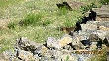
Kargil is home to many endangered wildlife species like snow leopard (Panthera uncia), Tibetan wolf (Canis lupus langier), Himalayan brown bear (Ursus arctos isabellinus), Asiatic ibex (Capra ibex), Ladakh urial (Ovis vignei vignei), musk deer (Moschus spp.), pikas, marmots and hares. Aishwarya Maheshwari of the World Wildlife Fund (WWF) is quoted as saying, "It is here in Kargil that one of world’s most elusive creatures, the snow leopard, roams wild and free. During my research I have learnt about the tremendous decline in wildlife sightings since the 1999 Kargil war, so much so that even the common resident birds had disappeared."[28][29][30] Besides these endangered form of life various species of birds including the black necked magpie, house sparrow, hoopoe,[31] rosefinches, red-billed choughs, eastern chiffchaff, common sandpiper and European goldfinches are a common sight in the summer.[32] The Indian Army rears horses, donkeys and mares for transportation purposes.
Administration

The Kargil district was formed in July 1979, by separating it from Leh. It is dived into four (4) Sub-Divisions: Drass, Zanskar, Sankoo and Shakar-Chiktan.[33] These are further divided into 12 Blocks:[34]
- Drass
- Kargil
- Shargole
- Shakar-Chiktan
- TSG
- Gund Mangalpore- Trespone
- Sankoo
- Taisuru
- Padum
- Lungnaq
- Cha
- Zangla
Each block consists of a number of panchayats.
Politics
Kargil District has two assembly constituencies, Zanskar and Kargil.[35] It forms part of the Ladakh parliamentary constituency. Major political parties in the region includes National Conference, Congress, PDP, BJP, LUTF (now merged with the BJP) and the erstwhile Kargil Alliance. The present Member of Parliament for Ladakh is Jamyang Tsering Namgyal of Bharatiya Janata Party.
Vikas kundal, (IAS) is the current District Development Commissioner Kargil.[36]
Autonomous Hill Council
Kargil District is administered by an elected body known as the Ladakh Autonomous Hill Development Council, Kargil. The LAHDC-K was established in 2003.
References
- District Census Handbook 2011, p. 7.
- "Archived copy". Archived from the original on 13 November 2013. Retrieved 19 September 2011.CS1 maint: archived copy as title (link)
- "Article 370 revoked Updates: Jammu & Kashmir is now a Union Territory, Lok Sabha passes bifurcation bill". www.businesstoday.in.
- Radhika Gupta, Allegiance and Alienation (2013), p. 49.
- Grist, Urbanisation in Kargil 2008, p. 80.
- Kalla, Krishan Lal (1997). Kashmir Panorama. Raj Publications. ISBN 978-81-86208-07-6.
- Huttenback, Gulab Singh and the Creation of the Dogra State 1961, p. 477.
- Huttenback, Gulab Singh and the Creation of the Dogra State 1961, p. 480.
- Panikkar, Gulab Singh 1930, pp. 77–78.
- Huttenback, Gulab Singh and the Creation of the Dogra State 1961, pp. 481–482.
- Panikkar, Gulab Singh 1930, pp. 78–80.
- Panikkar, Gulab Singh 1930, p. 112.
- Karim, Kashmir The Troubled Frontiers 2013, pp. 30–31.
- Aggarwal, Beyond Lines of Control 2004, p. 35.
- Kargil: what might have happened By Javed Hussain 21 October 2006, Dawn
- Assault on Enemy OPs in Kargil Posts that were returned in 1965 twice occupied again Archived 2006-11-05 at the Wayback Machine - A dramatised account of India's assault on Kargil during the 71 war hosted on The Liberation Times (a commemorative online newspaper)
- The Lightning Concept by Major General D.K. Palit (Retd.) Archived 2006-05-02 at the Wayback Machine
- The Armed Forces of Pakistan By Pervaiz Iqbal Cheema, Pg 4
- Pak considers Kargil-Skardu bus 15 March 2007 NDTV
- "Kargil district census data 2011" (PDF). Archived from the original (PDF) on 20 February 2019. Retrieved 20 February 2019.
- Gellner, David N. (2013). Borderland Lives in Northern South Asia. Duke University Press. pp. 49–51. ISBN 978-0-8223-7730-6.
- Rather, Ali Mohammad (September 1999), "Kargil: The Post-War Scenario", Journal of Peace Studies, International Center for Peace Studies, 6 (5–6), archived from the original on 1 December 2014
- Janet Rizvi. (1996). Ladakh: Crossroads of High Asia. Second Edition, pp. 210-211. Oxford University Press, Delhi. ISBN 0-19-564546-4.
- Anjuman Jamiatul Ulama Houzai Elmiya Madrasa Asna Asharia Islamia School Kargil
- IKMT Kargil
- Climate: Kargil - Climate graph, Temperature graph, Climate table
- "Climatological Information for Kargil, Ladakh", Hong Kong Observatory, 2003. Web: HKO-Marrakech.
- "India, Pakistan and the Snow Leopard: Javed Naqi". Kafila. 28 January 2012. Retrieved 16 August 2013.
- Voices from Frozen Land (24 January 2012). "Javed Naqi: Human-Wildlife Conflict in Kargil: Precipitation of India-Pakistan Rivalry?". Javed-naqi.blogspot.in. Retrieved 16 August 2013.
- "Human-Wildlife Conflict in Kargil: Precipitation of India-Pakistan Rivalry? | Bargad... बरगद". Bargad.org. 1 February 2012. Archived from the original on 8 August 2014. Retrieved 16 August 2013.
- The Indian Encyclopaedia - Google Books. Books.google.co.in. Retrieved 16 August 2013.
- Alok Bhave (6 October 2011). "Nature watch: Trip to Cold Desert - Ladakh Part2". Alokbhave.blogspot.in. Retrieved 16 August 2013.
- , Kargil District, Jammu and Kashmir.
- Statement showing the number of blocks in respect of 22 Districts of Jammu and Kashmir State including newly Created Districts Archived 2008-09-10 at the Wayback Machine dated 13 March 2008, accessed 2008-08-30
- "ERO's and AERO's". Chief Electoral Officer, Jammu and Kashmir. Archived from the original on 22 October 2008. Retrieved 28 August 2008.
- "Profile of Deputy Ccommissioners". Kargil.nic.in. Archived from the original on 27 July 2013. Retrieved 16 August 2013.
Bibliography
- District Census Handbook: Kargil (PDF), Directorate of Census Opeations, Jammu and Kashmir, 2011
- Aggarwal, Ravina (2004), Beyond Lines of Control: Performance and Politics on the Disputed Borders of Ladakh, India, Duke University Press, ISBN 0-8223-3414-3
- Grist, Nicola (2008). "Urbanisation in Kargil and its Effects in the Suru Valley". In Martijn van Beek; Fernanda Pirie (eds.). Modern Ladakh: Anthropological Perspectives on Continuity and Change. BRILL. ISBN 978-90-474-4334-6.
- Gupta, Radhika (2013). "Allegiance and Alienation: Border Dynamics in Kargil". In David N. Gellner (ed.). Borderland Lives in Northern South Asia. Duke University Press. pp. 47–71. ISBN 978-0-8223-7730-6.
- Huttenback, Robert A. (1961), "Gulab Singh and the Creation of the Dogra State of Jammu, Kashmir, and Ladakh" (PDF), The Journal of Asian Studies, 20 (4): 477–488, doi:10.2307/2049956
- Karim, Maj Gen Afsir (2013), Kashmir The Troubled Frontiers, Lancer Publishers LLC, pp. 30–, ISBN 978-1-935501-76-3
- Panikkar, K. M. (1930), Gulab Singh, London: Martin Hopkinson Ltd
- Ghulam Mohiuddin Dar. Kargil: Its social, culture, and economic history.
- Kargil : The Important Trade Transit of Yesteryears, People & Society
- Shireen M. Mazari, The Kargil Conflict, 1999: Separating Fact from Fiction, The Institute of Strategic Studies, Islamabad (2003) ISBN 969-8772-00-6
External links
| Wikimedia Commons has media related to Kargil district. |
- Rivers of Kargil district on OpenStreetMap: Dras, Suru and Kartse, Wakha, Zanskar
- "District Kargil", Official Kargil Site
- Ladakh Autonomous Hill Development Council, Kargil
- Kargil Tehsil Map, MapsofIndia.com
- "Pakistan's Northern Areas dilemma", BBC
Places adjacent to Kargil district | |
|---|---|
| History |
| ||||||||
|---|---|---|---|---|---|---|---|---|---|
| Administration | |||||||||
| Geography |
| ||||||||
| Settlements and locations | |||||||||
| Districts | |||||||||
| Dam |
| ||||||||
| Monasteries | |||||||||
| Transport | |||||||||
| See also | |||||||||