Ropotamo Glacier
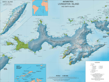
Ropotamo Glacier (Bulgarian: ледник Ропотамо, romanized: lednik Ropotamo, IPA: [ˈlɛdnik ropoˈtamo]) is a glacier extending 900 m in northeast-southwest direction and 600 m in northwest-southeast direction on the Burgas Peninsula, Livingston Island in the South Shetland Islands, Antarctica and situated northeast o Dobrudzha Glacier, east-southeast of Iskar Glacier, south of Sopot Ice Piedmont and southwest of Strandzha Glacier. It is bounded by Asen Peak and Delchev Peak to the northwest and north, and flows southeastwards mostly into Yantra Cove, Bransfield Strait.
| Ropotamo Glacier | |
|---|---|
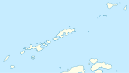
 Location of Burgas Peninsula on Livingston Island in the South Shetland Islands | |
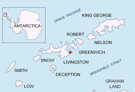
 Location of Ropotamo Glacier in Antarctica  Ropotamo Glacier (Antarctica) | |
| Location | Livingston Island South Shetland Islands |
| Coordinates | 62°38′55″S 59°55′34″W |
| Length | 0.5 nautical miles (0.93 km; 0.58 mi) |
| Width | 0.3 nautical miles (0.56 km; 0.35 mi) |
| Thickness | unknown |
| Terminus | Yantra Cove |
| Status | unknown |
Location
Ropotamo Glacier is centered at 62°38′55″S 59°55′34″W. Bulgarian mapping in 2005 and 2009.
Maps
- L.L. Ivanov et al. Antarctica: Livingston Island and Greenwich Island, South Shetland Islands. Scale 1:100000 topographic map. Sofia: Antarctic Place-names Commission of Bulgaria, 2005.
- L.L. Ivanov. Antarctica: Livingston Island and Greenwich, Robert, Snow and Smith Islands. Scale 1:120000 topographic map. Troyan: Manfred Wörner Foundation, 2009. ISBN 978-954-92032-6-4
References
- Ropotamo Glacier. SCAR Composite Antarctic Gazetteer
- Bulgarian Antarctic Gazetteer. Antarctic Place-names Commission. (details in Bulgarian, basic data in English)
External links
- Ropotamo Glacier. Copernix satellite image
This article includes information from the Antarctic Place-names Commission of Bulgaria which is used with permission.