Dobrodan Glacier
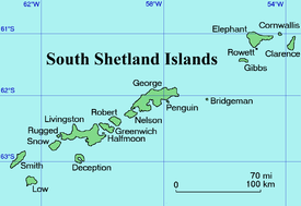
Dobrodan Glacier (Bulgarian: ледник Добродан, romanized: lednik Dobrodan, IPA: [ˈlɛdniɡ dobroˈdan]) is the 3.4 km long and 1.2 km wide glacier on the east side of Urda Ridge on Clarence Island in the South Shetland Islands, Antarctica situated south of Highton Glacier. It drains the slopes of Mount Irving and Duclos-Guyot Bluff, flows northeastwards and enters the Southern Ocean south of Lebed Point.
| Dobrodan Glacier | |
|---|---|
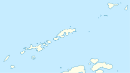
 Location of Clarence Island in the South Shetland Islands | |
 Location of Dobrodan Glacier in Antarctica  Dobrodan Glacier (Antarctica) | |
| Location | Clarence Island South Shetland Islands |
| Coordinates | 61°16′15″S 54°04′20″W |
| Length | 1.8 nmi (3 km; 2 mi) |
| Width | 0.6 nmi (1 km; 1 mi) |
| Thickness | unknown |
| Terminus | Lebed Point |
| Status | unknown |
.jpg)
Clarence Island seen from northeast with (left to right) Cape Bowles; Dobrodan Glacier and Highton Glacier surmounted by Urda Ridge; Treskavets Glacier, Orcho Glacier and Banari Glacier surmounted by Ravelin Ridge; and Cape Lloyd
The glacier is named after the settlement of Dobrodan in Northern Bulgaria.
Location
Dobrodan Glacier is centred at 61°16′15″S 54°04′20″W. British mapping in 1972 and 2009.
Maps
- British Antarctic Territory. Scale 1:200000 topographic map. DOS 610 Series, Sheet W 61 54. Directorate of Overseas Surveys, Tolworth, UK, 1972.
- South Shetland Islands: Elephant, Clarence and Gibbs Islands. Scale 1:220000 topographic map. UK Antarctic Place-names Committee, 2009.
- Antarctic Digital Database (ADD). Scale 1:250000 topographic map of Antarctica. Scientific Committee on Antarctic Research (SCAR), 1993–2016.
References
- Bulgarian Antarctic Gazetteer. Antarctic Place-names Commission. (details in Bulgarian, basic data in English)
- Dobrodan Glacier SCAR Composite Gazetteer of Antarctica
External links
- Dobrodan Glacier. Copernix satellite image
This article includes information from the Antarctic Place-names Commission of Bulgaria which is used with permission.
This article is issued from Wikipedia. The text is licensed under Creative Commons - Attribution - Sharealike. Additional terms may apply for the media files.