Thwaites Glacier
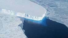
Thwaites Glacier (75°30′S 106°45′W), sometimes referred to as the Doomsday Glacier,[1] is an unusually broad and fast Antarctic glacier flowing into the Pine Island Bay, part of the Amundsen Sea, east of Mount Murphy, on the Walgreen Coast of Marie Byrd Land.[2] Its surface speeds exceed 2 kilometres per year (1.2 miles per year) near its grounding line. Its fastest flowing grounded ice is centred between 50 and 100 kilometres (31 and 62 mi) east of Mount Murphy. It was named by the Advisory Committee on Antarctic Names[3] in 1967 after Fredrik T. Thwaites (1883–1961), a glacial geologist, geomorphologist and professor emeritus at the University of Wisconsin–Madison.[4] The historian Reuben Gold Thwaites was his father.[5]
.jpg)
Thwaites Glacier is closely watched for its potential to raise sea levels.[6] Along with the Pine Island Glacier, it has been described as part of the "weak underbelly" of the West Antarctic Ice Sheet, due to its apparent vulnerability to significant retreat. This hypothesis is based on both theoretical studies of the stability of marine ice sheets and observations of large changes on these two glaciers. In recent years, the flow of both of these glaciers has accelerated, their surfaces have lowered, and their grounding lines have retreated.
Research
In 2001, a study of Thwaites Glacier using satellite radar interferometry data from the Earth Remote Sensing Satellite 1 and 2 revealed that the grounding line of Thwaites Glacier was retreating at 1 kilometer per year and that the glacier was significantly out of mass balance, hence confirming presumptions of collapse by Terence Hughes, University of Maine, in 1973. In 2002, a team of scientists from Chile and NASA on board an Orion P3 from the Chilean Navy collected the first radar sounding and laser altimetry survey of the glacier to reveal extensive thinning and acceleration in thinning. This discovery prompted an extensive airborne campaign in 2004 by the University of Texas, Austin, Texas, to be followed by subsequent airborne campaigns under NASA's IceBridge Campaign in 2009–2018.
In 2011, using geophysical data collected from flights over Thwaites Glacier (data collected under NASA's IceBridge campaign), a study by scientists at Columbia University's Lamont-Doherty Earth Observatory showed a rock feature, a ridge 700 meters tall that helps anchor the glacier and helped slow the glacier's slide into the sea. The study also confirmed the importance of seafloor topography in predicting how the glacier will behave in the near future.[7] However, the glacier has been considered to be the biggest threat on relevant time scales, for rising seas, current studies aim to better quantify retreat and possible impacts.[8] Since the 1980s, the glacier has had a net loss of over 600 billion tons of ice.[9] In 2017, scientists discovered previously unknown volcanoes nearby.[10]
In 2020, scientists discovered warm water underneath the glacier for the first time.[11] The place where the glacier was in contact with the sea had been recorded as 2 degree Celsius above the freezing temperature.[12] The discovery was a part of the International Thwaites Glacier Collaboration, a US-UK-based research firm. This study has raised alarm regarding the glacier collapse, which can lead to nearly 3 ft rise in the sea level.[13]
Water drainage beneath the glacier
Swamp-like canal areas and streams underlie the glacier. The upstream swamp canals feed streams with dry areas between the streams which retard flow of the glacier. Due to this friction the glacier is considered stable in the short term.[14]
Features and observation
Thwaites Glacier Tongue
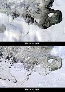
The Thwaites Glacier Tongue, or Thwaites Ice Tongue (75°0′S 106°50′W), is about 50 km wide and has progressively shortened due to ice calving, based on the observational record. It was initially delineated from aerial photographs collected during Operation Highjump in January 1947.
On 15 March 2002, the National Ice Center reported that an iceberg named B-22 broke off from the ice tongue. This iceberg was about 85 km long by 65 km wide, with a total area of some 5,490 km². As of 2003, B-22 had broken into five pieces, with B-22A still in the vicinity of the tongue, while the other smaller pieces had drifted farther west.
Thwaites Iceberg Tongue
The Thwaites Iceberg Tongue (74°0′S 108°30′W) was a large iceberg tongue which was aground in the Amundsen Sea, about 32 km northeast of Bear Peninsula. The feature was about 112 km long and 32 km wide, and in January 1966 its southern extent was only 5 km north of Thwaites Glacier Tongue. It consisted of icebergs which had broken off from the Thwaites Ice Tongue and ran aground, and should not be confused with the latter, which is still attached to the grounded ice. It was delineated by the USGS from aerial photographs collected during Operation Highjump and Operation Deepfreeze.[21] It was first noted in the 1930s, but finally detached from the ice tongue and broke up in the late 1980s.[22][23]
Underwater cavity
In January 2019, NASA discovered an underwater cavity underneath the glacier, with an area two-thirds the size of Manhattan. The cavity formed mostly in the previous three years and is nearly a thousand feet tall, likely speeding up the glacier's decay. Thwaites currently contributes roughly 4% to global sea level rise.[24]
International Thwaites Glacier Collaboration (ITGC)
A 5-year international collaboration to study the Thwaites Glacier was established in 2018.[25][26]
At the beginning of 2020, researchers from the ITGC took measurements to develop scenarios for the future of the glacier and to predict the time frame for a possible collapse: The erosion of the glacier by warmed ocean water seems to be stronger than expected. The researchers noted with concern, that at the baseline of the glacier, the temperature of the water is already more than two degrees above freezing point. They confirm thawing of the Thwaites glacier contributes about four percent of global sea-level rise. The collapse of this glacier alone would raise the sea level by about 65 centimetres (25 inches).[27]
See also
References

- Antarctica melting: Climate change and the journey to the 'doomsday glacier' BBC News, 28 January 2020.
- "Thwaites Glacier: Antarctica, name, geographic coordinates, description, map". Geographic.org. Retrieved 2014-05-13.
- "Thwaites Glacier Tongue". Geographic Names Information System. United States Geological Survey. Retrieved 23 October 2011.
- "Thwaites Glacier". Geographic Names Information System. United States Geological Survey. Retrieved 23 October 2011.
- Bloom, Danny (13 March 2019). "Time 'Thwaites' for no one: the story behind Thwaites Glacier in Antarctica". Times of Israel. Retrieved 21 June 2020.
- Jon Gertner (10 December 2018). "The Race to Understand Antarctica's Most Terrifying Glacier". Wired.com. Retrieved 15 December 2018.
- "Scientists Predict Faster Retreat for Antarctica’s Thwaites Glacier - The Earth Institute - Columbia University". www.earth.columbia.edu.
- "This Antarctic glacier is the biggest threat for rising sea levels. The race is on to understand it". The Washingtoin Post. October 20, 2016.
- Patel, Jugal K. (October 26, 2017). "In Antarctica, Two Crucial Glaciers Accelerate Toward the Sea". The New York Times. Retrieved February 4, 2019.
- "Scientists discover 91 volcanoes below Antarctic ice sheet". The Guardian. August 12, 2017. Retrieved February 10, 2020.
- "Rising Seas: Record Warmth Found at 'Doomsday Glacier' Water Line - ExtremeTech". www.extremetech.com. Retrieved 2020-02-05.
- Editor 2020-01-30T16:57:52Z, Laura Geggel-Associate. "Surprisingly warm water found on underside of Antarctica's 'Doomsday Glacier'". livescience.com. Retrieved 2020-02-05.CS1 maint: extra text: authors list (link)
- "Scientists discover warm water beneath 'Doomsday Glacier' in Antarctica". Times of India Travel. Retrieved 2020-02-05.
- "Scientists Image Vast Subglacial Water System Underpinning West Antarctica's Thwaites Glacier". University of Texas. July 9, 2013. Archived from the original on July 15, 2013. Retrieved July 9, 2013.
- "Irreversible collapse of Antarctic glaciers has begun, studies say". Los Angeles Times. May 12, 2014. Retrieved May 13, 2014.
- Sumner, Thomas (April 8, 2016). "Changing climate: 10 years after An Inconvenient Truth". Science News. Retrieved July 25, 2016.
- Feldmann, J; Levermann, A (November 17, 2015). "Collapse of the West Antarctic Ice Sheet after local destabilization of the Amundsen Basin". Proceedings of the National Academy of Sciences. 112: 14191–14196. doi:10.1073/pnas.1512482112. PMC 4655561. PMID 26578762.
- Rignot, E. (12 May 2014). "Widespread, rapid grounding line retreat of Pine Island, Thwaites, Smith, and Kohler glaciers, West Antarctica, from 1992 to 2011" (PDF). Geophysical Research Letters. 41: 3502–3509. doi:10.1002/2014GL060140.
- Joughin, I. (16 May 2014). "Marine Ice Sheet Collapse Potentially Under Way for the Thwaites Glacier Basin, West Antarctica". Science. 344: 735–738. doi:10.1126/science.1249055. PMID 24821948.
- Tucker, Danielle Torrent (2019-09-02). "Vintage film reveals Antarctic glacier melting". Stanford News. Retrieved 2019-09-07.
- "Thwaites Iceberg Tongue". Geographic Names Information System. United States Geological Survey. Retrieved 23 October 2011.
- Reynolds, Larry (4 March 2000). "Where a cold tongue isn't". Teachers Experiencing Antarctica. Retrieved 16 June 2009.
- Lucchitta, B.K.; Smith, C.E.; Bowel, J.; Mullins, K.F. (1994). "Velocities and mass balance of Pine Island Glacier, West Antarctica, derived from ERS-1 SAR". Pub. SP-361, 2nd ERS-1 Symposium, Space at the Service of Our Environment, Hamburg, Germany, 11–14, Oct. 1993 Proceedings. pp. 147–151.
- Jacobs, Julia (February 1, 2019). "Gigantic Cavity in Antarctica Glacier Is a Product of Rapid Melting, Study Finds". The New York Times. Retrieved February 4, 2019.
- Beeler, Carolyn. "Is Thwaites Glacier doomed? Scientists are racing to find out". Public Radio International. Retrieved 2019-06-02.
- "International Thwaites Glacier Collaboration (ITGC)". thwaitesglacier.org. Retrieved 2019-06-02.
- "Scientists drill for first time on remote Antarctic Glacier". thwaitesglacier.org. 2020-01-28. Retrieved 2020-01-31.
External links
- U.S. Geological Survey Geographic Names Information System: Thwaites Glacier
- Thwaites Glacier on geographic.org
- International Thwaites Glacier Collaboration ITGC website
- Visiting the most vulnerable place on Earth: the 'doomsday glacier' on YouTube published Feb 19, 2020 PBS NewsHour