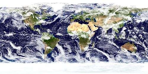
Glaciology
Glaciology (from Latin: glacies, "frost, ice", and Ancient Greek: λόγος, logos, "subject matter"; literally "study of ice") is the scientific study of glaciers, or more generally ice and natural phenomena that involve ice.
Glaciology is an interdisciplinary Earth science that integrates geophysics, geology, physical geography, geomorphology, climatology, meteorology, hydrology, biology, and ecology. The impact of glaciers on people includes the fields of human geography and anthropology. The discoveries of water ice on the Moon, Mars, Europa and Pluto add an extraterrestrial component to the field, which is referred to as "astroglaciology".[1]
Overview
A glacier is an extended mass of ice formed from snow falling and accumulating over a long period of time; glaciers move very slowly, either descending from high mountains, as in valley glaciers, or moving outward from centers of accumulation, as in continental glaciers.
Areas of study within glaciology include glacial history and the reconstruction of past glaciation. A glaciologist is a person who studies glaciers. A glacial geologist studies glacial deposits and glacial erosive features on the landscape. Glaciology and glacial geology are key areas of polar research.
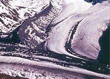
Types
.jpg)
Glaciers can be identified by their geometry and the relationship to the surrounding topography. There are two general categories of glaciation which glaciologists distinguish: alpine glaciation, accumulations or "rivers of ice" confined to valleys; and continental glaciation, unrestricted accumulations which once covered much of the northern continents.
- Alpine – ice flows down the valleys of mountainous areas and forms a tongue of ice moving towards the plains below. Alpine glaciers tend to make topography more rugged by adding and improving the scale of existing features. Various features include large ravines called cirques and arêtes, which are ridges where the rims of two cirques meet.
- Continental – an ice sheet found today, only in high latitudes (Greenland/Antarctica), thousands of square kilometers in area and thousands of meters thick. These tend to smooth out the landscapes.
Zones of glaciers
- Accumulation – where the formation of ice is faster than its removal.
- Wastage (or ablation) – when the sum of melting, calving, and evaporation (sublimation) is greater than the amount of snow added each year.
- Snow line – the area that marks the transition from glacial accumulation to the ablation zone and vice versa.
Movement
When a glacier is experiencing an input of precipitation that exceeds the output, the glacier is advancing. Conversely, if the output from evaporation, sublimation, melting, and calving exceed the glaciers precipitation input the glacier is receding. This is referred to as an interglacial period. During periods where ice is advancing at an extreme rate, that is typically 100 times faster than what is considered normal, it is referred to as a surging glacier. During times in which the input of precipitation to the glacier is equivalent to the ice lost from calving, evaporation, and melting of the glacier, there is a steady-state condition. Within the glacier, the ice has a downward movement in the accumulation zone and an upwards movement in the ablation zone.
Climate Change and Glaciers
Glaciers are a valuable resource for tracking climate change over long periods of time because they can be hundreds of thousands of years old. To study the patterns over time through glaciers, ice cores are taken, providing continuous information including evidence for climate change, trapped in the ice for scientists to break down and study.[3] Glaciers are studied to give information about the history of climate change due to natural or human causes.[4] Human activity has caused an increase in greenhouse gases creating a global warming trend,[4] causing these valuable glaciers to melt. Glaciers have an albedo effect and with the melting of glaciers means less albedo. In the Alps the summer of 2003 was compared to the summer of 1988. Between 1998 and 2003 the albedo value is 0.2 lower in 2003.[5] When glaciers begin to melt, they also cause a rise in sea level, "which in turn increases coastal erosion and elevates storm surge as warming air and ocean temperatures create more frequent and intense coastal storms like hurricanes and typhoons.[6]" Thus, human causes to climate change creates a positive feedback loop with the glaciers: The rise in temperature causes more glacier melt, leading to less albedo, higher sea levels and many other climate issues to follow. From 1972 all the way up to 2019 NASA has used a Landsat satellite that has been used to record glaciers in Alaska, Greenland and Antarctica. This Landsat project has found that since around 2000, glacier retreat has increased substantially.[7]

Glacial Terminology
- Ablation
- Wastage of the glacier through sublimation, ice melting and iceberg calving.
- Ablation zone
- Area of a glacier in which the annual loss of ice through ablation exceeds the annual gain from precipitation.
- Arête
- An acute ridge of rock where two cirques meet.
- Bergschrund
- Crevasse formed near the head of a glacier, where the mass of ice has rotated, sheared and torn itself apart in the manner of a geological fault.
- Cirque, Corrie or cwm
- Bowl shaped depression excavated by the source of a glacier.
- Creep
- Adjustment to stress at a molecular level.
- Flow
- Movement (of ice) in a constant direction.
- Fracture
- Brittle failure (breaking of ice) under the stress raised when movement is too rapid to be accommodated by creep. It happens for example, as the central part of a glacier moves faster than the edges.
- Moraine
- Accumulated debris that has been carried by a glacier and deposited at its sides (lateral moraine) or at its foot (terminal moraine).
- Névé
- Area at the top of a glacier (often a cirque) where snow accumulates and feeds the glacier.
- Horn
- Spire of rock, also known as a pyramidal peak, formed by the headward erosion of three or more cirques around a single mountain. It is an extreme case of an arête.
- Plucking/Quarrying
- Where the adhesion of the ice to the rock is stronger than the cohesion of the rock, part of the rock leaves with the flowing ice.
- Tarn
- A post-glacial lake in a cirque.
- Tunnel valley
- The tunnel that is formed by hydraulic erosion of ice and rock below an ice sheet margin. The tunnel valley is what remains of it in the underlying rock when the ice sheet has melted.
Rate of movement
Movement of the glacier is very slow. Its velocity varies from a few centimeters per day to a few meters per day. The rate of movement depends upon the numbers of factors which are listed below :
- Temperature of the ice
- Gradient of the slope
- Thickness of the glacier[9]
- Subglacial water dynamics
Glacial deposits[9]
Stratified
- Outwash sand/gravel
- From front of glaciers, found on a plain.
- Kettles
- When a lock of stagnant ice leaves a depression or pit.
- Eskers
- Steep sided ridges of gravel/sand, possibly caused by streams running under stagnant ice.
- Kames
- Stratified drift builds up low steep hills.
- Varves
- Alternating thin sedimentary beds (coarse and fine) of a proglacial lake. Summer conditions deposit more and coarser material and those of the winter, less and finer.
Unstratified
.jpg)
- Till-unsorted
- (Glacial flour to boulders) deposited by receding/advancing glaciers, forming moraines, and drumlins.
- Moraines
- (Terminal) material deposited at the end; (Ground) material deposited as glacier melts; (lateral) material deposited along the sides.
- Drumlins
- Smooth elongated hills composed of till.
- Ribbed moraines
- Large subglacial elongated hills transverse to former ice flow.
See also
Notes
- Richard S. Williams, Jr. (1987). "Annals of Glaciology, v.9" (PDF). International Glaciological Society. p. 255. Retrieved 7 February 2011.
- Khurdopin glacier & Shimshal River, Pakistan
- "Glaciers and climate change | National Snow and Ice Data Center". nsidc.org. Retrieved 2020-03-31.
- "Climate Change: Glacier Mass Balance | NOAA Climate.gov". www.climate.gov. Retrieved 2020-02-26.
- Paul, Frank (February 2005). "On the Impact of Glacier Albedo Under Conditions of Extreme Glacier Melt: The Summer of 2003 in the Alps" (PDF). EARSeL eProceedings. 4: 139–149 – via University of Zurich, Department of Geography, Zurich, Switzerland.
- "Why are glaciers and sea ice melting?". World Wildlife Fund. Retrieved 2020-03-31.
- Center, By Kate Ramsayer, NASA's Godddard Space Flight. "Ice in Motion: Satellites Capture Decades of Change". Climate Change: Vital Signs of the Planet. Retrieved 2020-03-31.
- "USGS Fact Sheet 2009–3046: Fifty-Year Record of Glacier Change Reveals Shifting Climate in the Pacific Northwest and Alaska, USA". pubs.usgs.gov. Retrieved 2020-03-31.
- Mahapatra, G.B. (1994). Text book of Physical Geology. Nazia printers, Delhi. p. 269. ISBN 81-239-0110-0.
References
- Benn, Douglas I. and David J. A. Evans. Glaciers and Glaciation. London; Arnold, 1998. ISBN 0-340-58431-9
- Greve, Ralf and Heinz Blatter. Dynamics of Ice Sheets and Glaciers. Berlin etc.; Springer, 2009. ISBN 978-3-642-03414-5
- Hambrey, Michael and Jürg Alean. Glaciers. 2nd ed. Cambridge and New York; Cambridge University Press, 2004. ISBN 0-521-82808-2
- Hooke, Roger LeB. Principles of Glacier Mechanics. 2nd ed. Cambridge and New York; Cambridge University Press, 2005. ISBN 0-521-54416-5
- Paterson, W. Stanley B. The Physics of Glaciers. 3rd ed. Oxford etc.; Pergamon Press, 1994. ISBN 0-08-037944-3
- van der Veen, Cornelis J. Fundamentals of Glacier Dynamics. Rotterdam; A. A. Balkema, 1999. ISBN 90-5410-471-6
External links
| Wikimedia Commons has media related to Glaciology. |
- International Glaciological Society (IGS)
- International Association of Cryospheric Sciences (IACS)
- Snow, Ice, and Permafrost Group, University of Alaska Fairbanks
- Arctic and Alpine Research Group, University of Alberta
- Glaciers online
- World Data Centre for Glaciology, Cambridge, UK
- National Snow and Ice Data Center, Boulder, Colorado
- Global Land Ice Measurements from Space (GLIMS)
- Glacial structures – photo atlas
- North Cascade Glacier Climate Project
- Centre for Glaciology, University of Wales
- Caltech Glaciology Group
- Glaciology Group, University of Copenhagen
- Institute of Low Temperature Science, Sapporo
- National Institute of Polar Research, Tokyo
- Glaciology Group, University of Washington
- Glaciology Laboratory, Universidad de Chile-Centro de Estudios Científicos, Valdivia
- Russian Geographical Society (Moscow Centre) – Glaciology Commission
- Institute of Meteorology and Geophysics, Univ. of Innsbruck, Austria.
| |||||||||||||||||||||||||||||||||||||||||