Philippi Glacier, Antarctica
Philippi Glacier (German: Philippigletscher) is coastal glacier about 15 mi long, flowing N to the E end of the West Ice Shelf, 15 mi W of Gaussberg. Delineated from aerial photographs taken by U.S. Navy (USN) OpHjp, 1946–47. Named by the ANCA for Emil Philippi, geologist with the German Antarctic Expedition (GerAE) under Erich von Drygalski, 1901–03, who made scientific observations in the vicinity of Gaussberg.
| Philippi Glacier | |
|---|---|
 Kaiser Wilhelm II Land | |
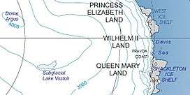
 Location of Philippi Glacier in Antarctica | |
| Type | channell |
| Location | Kaiser Wilhelm II Land |
| Coordinates | 66°45′S 88°20′E |
| Length | 15 nmi (28 km; 17 mi) |
| Thickness | unknown |
| Terminus | West Ice Shelf |
| Status | unknown |
References
![]()
![]()
| Types |
| ||||||
|---|---|---|---|---|---|---|---|
| Anatomy |
| ||||||
| Processes | |||||||
| Measurements | |||||||
| Volcanic relations | |||||||
| Landforms |
| ||||||
| |||||||
Glaciers of Kaiser Wilhelm II Land | |
|---|---|
This article is issued from Wikipedia. The text is licensed under Creative Commons - Attribution - Sharealike. Additional terms may apply for the media files.