Kaiser Wilhelm II Land
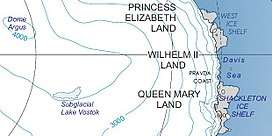
Kaiser Wilhelm II Land is a part of Antarctica lying between Cape Penck at 87° 43'E and Cape Filchner at 91° 54'E, and is claimed as part of the Australian Antarctic Territory, a claim not universally recognized.

Exploration
The area was discovered on 22 February 1902, during the Gauss expedition of 1901–1903 led by Arctic veteran and geologist Erich von Drygalski. Drygalski named it after Kaiser Wilhelm II[1] who had funded the expedition with 1.2 million Goldmarks.
Also discovered was the Gaussberg, a 370-metre-high (1,210 ft) extinct volcano named after mathematician and physicist Carl Friedrich Gauss.
References
- "Wilhelm II Coast". Geographic Names Information System. United States Geological Survey. Retrieved 2013-04-12.
![]()