Huntington–Ashland metropolitan area
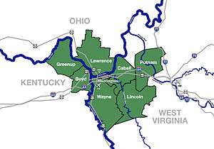
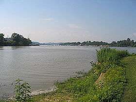
The Huntington–Ashland metropolitan area is a metropolitan area in the Appalachian Plateau region of the United States. Referred to locally as the “Tri-State area”, the region spans seven counties in the three states of West Virginia, Kentucky, and Ohio. With a population of 361,580,[3] the Tri-State area is nestled along the banks of the Ohio River.
Tri-State Area | |
|---|---|
| Huntington–Ashland, WV–KY–OH MSA | |
 | |
| Coordinates: 38°25′09″N 82°26′43″W | |
| Country | United States |
| State(s) | West Virginia, Kentucky, Ohio |
| Largest city | Huntington |
| Other cities | - Ashland - Ironton - Teays Valley - Flatwoods |
| Area | |
| • Total | 2,159.9 sq mi (5,594 km2) |
| Highest elevation | Kelly Knob[1] 1,512 ft (461 m) |
| Lowest elevation | Ohio River[2] 485 ft (148 m) |
| Population (2015 est.) | |
| • Total | 361,580 |
| • Rank | 146th in the U.S. |
| • Density | 167.4/sq mi (64.6/km2) |
Counties
| County | 2019 Estimate | 2010 Census | Change |
|---|---|---|---|
| Cabell County | 91,945 | 96,319 | −4.54% |
| Lawrence County | 59,463 | 62,450 | −4.78% |
| Putnam County | 56,450 | 55,486 | +1.74% |
| Boyd County | 46,718 | 49,542 | −5.70% |
| Wayne County | 39,402 | 42,481 | −7.25% |
| Greenup County | 35,098 | 36,910 | −4.91% |
| Lincoln County | 20,409 | 21,720 | −6.04% |
| Total | 349,485 | 364,908 | −4.23% |
Communities


Largest cities (more than 5,000 inhabitants)
| City | Population (2011 est.) [4][5][6] |
Note |
|---|---|---|
| Huntington, West Virginia | 49,253 | Principal city of the MSA[7] |
| Ashland, Kentucky | 21,652 (2011)[8] |
Principal city of the MSA[7] |
| Teays Valley, West Virginia | 13,175 | Census-designated place (population as of 2010 census) |
| Ironton, Ohio | 11,135 | Incorporated city |
| Flatwoods, Kentucky | 7,412 | Incorporated city |
| Nitro, West Virginia (partial) | 7,178 | Incorporated city |
| Pea Ridge, West Virginia | 6,650 | Census-designated place (population as of 2010 census) |
| Hurricane, West Virginia | 6,284 | Incorporated city |
Places with 1,000 to 5,000 inhabitants
- Barboursville, West Virginia
- Buffalo, West Virginia
- Burlington, Ohio
- Catlettsburg, Kentucky
- Ceredo, West Virginia
- Coal Grove, Ohio
- Culloden, West Virginia (census-designated place)
- Eleanor, West Virginia
- Grayson, Kentucky
- Greenup, Kentucky
- Hamlin, West Virginia
- Kenova, West Virginia
- Lesage, West Virginia (census-designated place)
- Louisa, Kentucky
- Milton, West Virginia
- Olive Hill, Kentucky
- Raceland, Kentucky
- Rush, Kentucky (census-designated place)
- Russell, Kentucky
- South Point, Ohio
- South Shore, Kentucky
- Wayne, West Virginia
- Westwood, Kentucky (census-designated place)
- Worthington, Kentucky
- Wurtland, Kentucky
- Winfield, West Virginia
Places with fewer than 1,000 inhabitants
Unincorporated places
- Alkol, West Virginia
- Armilda, West Virginia
- Atenville, West Virginia
- Brabant, West Virginia
- Branchland, West Virginia
- Cannonsburg, Kentucky
- Coalton, Kentucky
- Confidence, West Virginia
- Crum, West Virginia
- Culloden, West Virginia
- Dollie, West Virginia
- Dunlow, West Virginia
- East Lynn, West Virginia
- Eden Park, West Virginia
- Etna, Ohio
- Ferrellsburg, West Virginia
- Fourteen, West Virginia
- Fraziers Bottom, West Virginia
- Fry, West Virginia
- Genoa, West Virginia
- Gill, West Virginia
- Green Shoal, West Virginia
- Griffithsville, West Virginia
- Hometown, West Virginia
- Ironville, Kentucky
- Kitts Hill, Ohio
- Lanham, West Virginia
- Leet, West Virginia
- Liberty, West Virginia
- Meads, Kentucky
- Midway, West Virginia
- Midkiff, West Virginia
- Ona, West Virginia
- Pedro, Ohio
- Pleasant View, West Virginia
- Pliny, West Virginia
- Princess, Kentucky
- Ranger, West Virginia
- Rector, West Virginia
- Raymond City, West Virginia
- Red House, West Virginia
- Rock Camp, Ohio
- Rockdale, Kentucky
- Salt Rock, West Virginia
- Sod, West Virginia
- Scott Depot, West Virginia
- Scottown, Ohio
- Spurlockville, West Virginia
- Sumerco, West Virginia
- Summit, Kentucky
- Sweetland, West Virginia
- Teays, West Virginia
- Warren, West Virginia
- Waterloo, Ohio
- Wewanta, West Virginia
- Willow Wood, Ohio
- Wilsondale, West Virginia
- Yawkey, West Virginia
Townships (Lawrence County, Ohio)
Demographics
As of 2018, there were 352,823 people and 136,769 households residing within the MSA. The racial makeup of the MSA was 93.9% White, 2.6% African American, 0.1% Native American, 0.5% Asian, 0.1% Pacific Islander, 0.1% from other races, and 1.8% from two or more races. Hispanic or Latino of any race were 1% of the population.
The median income for a household in the MSA was $45,535. The per capita income for the MSA was $25,801. 18.2% of the population is beneath the poverty line, including 23% of children and 11% of seniors.
In 2008, an Associated Press article designated the Huntington-Ashland metropolitan area as the unhealthiest in America, based on its analysis of data collected in 2006 by the Centers for Disease Control and Prevention. Nearly half the adults in this metropolitan area were obese.[9]
Major highways


Area codes
The following prefixes are used for long-distance phone service dialing to the region within the MSA.
- 304, 681 – West Virginia Counties
- 606 – Kentucky Counties
- 740 – Ohio
Higher education
See also
- Kentucky census statistical areas
- Ohio census statistical areas
- West Virginia census statistical areas
References
- "Kelly Knob". Geographic Names Information System. United States Geological Survey. Retrieved on 2010-08-19
- Groundwater Resources of Greenup County, Kentucky Retrieved on 2010-08-19
- "Population statistics" (PDF). Archived from the original (PDF) on March 19, 2013.
- "Annual Estimates of the Population for Incorporated Places in Kentucky". U.S. Census Bureau. Retrieved August 4, 2012.
- "Annual Estimates of the Population for Incorporated Places in Ohio". U.S. Census Bureau. Archived from the original on September 17, 2008. Retrieved January 27, 2009.
- "Annual Estimates of the Population for Incorporated Places in West Virginia". U.S. Census Bureau. Retrieved January 27, 2009.
- "Metropolitan and micropolitan statistical areas". U.S. Census Bureau, Population Division. August 4, 2012. Archived from the original on April 27, 2012. Retrieved August 4, 2012.
- "2011Demographic Profile Data: Ashland, Kentucky". American FactFinder. United States Census Bureau. Retrieved August 4, 2012.
- WILCOXHerald-Dispatch.com, LAURA. "Huntington area labeled as nation's most unhealthy". herald-dispatch.com. Retrieved April 1, 2018.


.svg.png)