Benham, Kentucky
Benham is a home rule-class city in Harlan County, Kentucky, in the United States. The city was formally incorporated by the General Assembly in 1961.[2] The population was 500 at the 2010 census[3] and estimated in 2018 to be 434.[1]
Benham, Kentucky | |
|---|---|
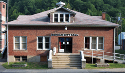 Benham City Hall | |
| Nickname(s): The Little Town That International Harvester, Coal Miners, and Their Families Built | |
 Location of Benham in Harlan County, Kentucky. | |
| Coordinates: 36°57′53″N 82°57′13″W | |
| Country | United States |
| State | Kentucky |
| County | Harlan |
| Incorporated | March 7, 1961 |
| Government | |
| • Mayor | Howard White |
| Area | |
| • Total | 0.2 sq mi (0.6 km2) |
| • Land | 0.2 sq mi (0.6 km2) |
| • Water | 0.0 sq mi (0.0 km2) |
| Elevation | 1,591 ft (485 m) |
| Population (2010) | |
| • Total | 500 |
| • Estimate (2018)[1] | 434 |
| • Density | 1,936/sq mi (747.6/km2) |
| Time zone | UTC-5 (EST) |
| • Summer (DST) | UTC-4 (EDT) |
| ZIP code | 40807 |
| Area code(s) | 606 |
| FIPS code | 21-05662 |
| GNIS feature ID | 0486849 |
| Website | www |
Geography
Benham is located in eastern Harlan County at 36°57′53″N 82°57′15″W (36.964832, -82.954035),[4] in the valley of Looney Creek, between Looney Ridge to the north and Benham Spur to the south. Looney Creek flows west to the Poor Fork of the Cumberland River in neighboring Cumberland.
Kentucky Route 160 is Benham's Main Street, leading west 2.5 miles (4.0 km) to Cumberland and east through Lynch 9 miles (14 km) to the Virginia border at the crest of Black Mountain just north of its summit, the highest point in Kentucky.
According to the United States Census Bureau, Benham has a total area of 0.23 square miles (0.6 km2), all of it land.[3]
Demographics
| Historical population | |||
|---|---|---|---|
| Census | Pop. | %± | |
| 1970 | 1,000 | — | |
| 1980 | 936 | −6.4% | |
| 1990 | 717 | −23.4% | |
| 2000 | 599 | −16.5% | |
| 2010 | 500 | −16.5% | |
| Est. 2018 | 434 | [1] | −13.2% |
| U.S. Decennial Census[5] | |||
At the 2000 census there were 599 people in 248 households, including 181 families, in the city. The population density was 1,519.2 people per square mile (593.0/km²). There were 288 housing units at an average density of 730.4 per square mile (285.1/km²). The racial makeup of the city was 88.81% White, 9.85% African American, 0.33% Native American, 0.17% Asian, 0.33% from other races, and 0.50% from two or more races. Hispanic or Latino of any race were 0.50%.[6]
Of the 248 households 31.0% had children under the age of 18 living with them, 59.3% were married couples living together, 9.7% had a female householder with no husband present, and 27.0% were non-families. 26.6% of households were one person and 19.4% were one person aged 65 or older. The average household size was 2.42 and the average family size was 2.88.
The age distribution was 22.9% under the age of 18, 4.5% from 18 to 24, 24.9% from 25 to 44, 28.2% from 45 to 64, and 19.5% 65 or older. The median age was 44 years. For every 100 females, there were 93.9 males. For every 100 females age 18 and over, there were 83.3 males.
The median household income was $25,250 and the median family income was $33,333. Males had a median income of $35,000 versus $24,844 for females. The per capita income for the city was $16,174. About 18.1% of families and 20.2% of the population were below the poverty line, including 26.8% of those under age 18 and 18.7% of those age 65 or over.
Environmental concerns
In 2010, various city employees and residents expressed concern for the city's relatively high-quality drinking water. While many claimed that the drinking water is cleaner than water anywhere else in the general area, many argued that underground coal mining will contaminate public water supplies for both Benham and the adjacent city of Lynch.[7]
Notable people
- Bernie Bickerstaff, NBA executive and head coach
See also
Gallery
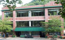 Kentucky Coal Museum
 Benham Schoolhouse Inn
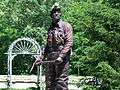 Coal Miner Statue
References
- "Population and Housing Unit Estimates". Retrieved March 17, 2020.
- Commonwealth of Kentucky. Office of the Secretary of State. Land Office. "Benham, Kentucky". Accessed 15 July 2013.
- "Geographic Identifiers: 2010 Demographic Profile Data (G001): Benham city, Kentucky". American Factfinder. U.S. Census Bureau. Retrieved June 27, 2017.
- "US Gazetteer files: 2010, 2000, and 1990". United States Census Bureau. 2011-02-12. Retrieved 2011-04-23.
- "Census of Population and Housing". Census.gov. Retrieved June 4, 2015.
- "U.S. Census website". United States Census Bureau. Retrieved 2008-01-31.
- "Benham & Lynch Underground Water Reservoirs Threatened". 2010-10-04. Retrieved 26 July 2012.
Municipalities and communities of Harlan County, Kentucky, United States | ||
|---|---|---|
| Cities | 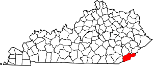 Location of Harlan County, Kentucky | |
| CDPs | ||
| Other unincorporated communities |
| |
| Ghost towns | ||

| Authority control |
|
|---|