Ross County, Ohio
Ross County is a county in the Appalachian region of the U.S. state of Ohio. As of the 2010 United States Census, the population was 78,064.[2] Its county seat is Chillicothe,[3] the first and third capital of Ohio. Established on August 20, 1798, the county is named for Federalist Senator James Ross of Pennsylvania.[4] Ross County comprises the Chillicothe, OH Micropolitan Statistical Area, which is also included in the Columbus-Marion-Zanesville, OH Combined Statistical Area.
Ross County | |
|---|---|
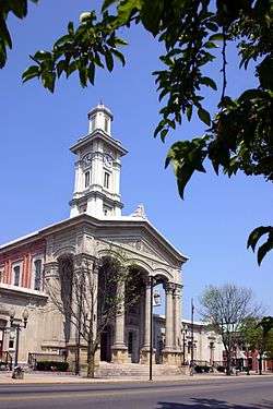 Ross County Courthouse | |
.svg.png) Seal | |
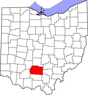 Location within the U.S. state of Ohio | |
 Ohio's location within the U.S. | |
| Coordinates: 39°20′N 83°04′W | |
| Country | |
| State | |
| Founded | 20 August 1798[1] |
| Named for | James Ross |
| Seat | Chillicothe |
| Largest city | Chillicothe |
| Area | |
| • Total | 693.03 sq mi (1,794.9 km2) |
| • Land | 689.19 sq mi (1,785.0 km2) |
| • Water | 3.84 sq mi (9.9 km2) 0.6%% |
| Population | |
| • Estimate (2019) | 76,666 |
| • Density | 113/sq mi (44/km2) |
| Time zone | UTC−5 (Eastern) |
| • Summer (DST) | UTC−4 (EDT) |
| Congressional districts | 2nd, 15th |
| Website | www |
History
As of 1848, Ross County was described as having almost "one hundred enclosures of various sizes, and five hundred mounds" by Ephraim George Squier and Edwin Hamilton Davis in their book, Ancient Monuments of the Mississippi Valley. They described the Indian-built earthworks as ranging from five to 30 feet in size, and enclosures of one to 50 acres large.[5]
Geography
The Scioto River flows southward through the east-central part of the county. Paint Creek drains the lower central part of the county, flowing eastward to its terminus with the Scioto at a point southeast of Chillicothe. The county terrain consists of frequent wooded hills, with the intermediate level areas devoted to agriculture.[6] The county's highest point is Farrell Hill, six miles (10 km) northeast of Bainbridge.[7] The county has a total area of 693 square miles (1,790 km2), of which 689 square miles (1,780 km2) is land and 3.8 square miles (9.8 km2) (0.6%) is water.[8] Ross County is the second-largest county by land area in Ohio, after Ashtabula County, as well as the fifth-largest by total area.
Adjacent counties
- Pickaway County - north
- Hocking County - northeast
- Vinton County - east
- Jackson County - southeast
- Pike County - south
- Highland County - southwest
- Fayette County - northwest
Protected areas
- Adena State Memorial[9]
- Great Seal State Park[10]
- Hopewell Culture National Historical Park
- Paint Creek State Park (part)
- Pleasant Valley Wildlife Area[6]
- Ross Lake Wilderness Area[6]
- Scioto Trail State Forest
- Scioto Trail State Park (part of American Discovery Trail)
- Tar Hollow State Forest (part)
Demographics
| Historical population | |||
|---|---|---|---|
| Census | Pop. | %± | |
| 1800 | 8,540 | — | |
| 1810 | 15,514 | 81.7% | |
| 1820 | 20,619 | 32.9% | |
| 1830 | 24,068 | 16.7% | |
| 1840 | 27,460 | 14.1% | |
| 1850 | 32,074 | 16.8% | |
| 1860 | 35,071 | 9.3% | |
| 1870 | 37,097 | 5.8% | |
| 1880 | 40,307 | 8.7% | |
| 1890 | 39,454 | −2.1% | |
| 1900 | 40,940 | 3.8% | |
| 1910 | 40,069 | −2.1% | |
| 1920 | 41,556 | 3.7% | |
| 1930 | 45,181 | 8.7% | |
| 1940 | 52,147 | 15.4% | |
| 1950 | 54,424 | 4.4% | |
| 1960 | 61,215 | 12.5% | |
| 1970 | 61,211 | 0.0% | |
| 1980 | 65,004 | 6.2% | |
| 1990 | 69,330 | 6.7% | |
| 2000 | 73,345 | 5.8% | |
| 2010 | 78,064 | 6.4% | |
| Est. 2019 | 76,666 | [11] | −1.8% |
| US Decennial Census[12] 1790-1960[13] 1900-1990[14] 1990-2000[15] 2010-2019[2] | |||
2000 census
As of the 2000 United States Census,[16] there were 73,345 people, 27,136 households, and 19,185 families in the county. The population density was 106/sqmi (41.1/km²). There were 29,461 housing units at an average density of 42.7/sqmi (16.5/km²). The racial makeup of the county was 91.74% White, 6.20% Black or African American, 0.31% Native American, 0.35% Asian, 0.02% Pacific Islander, 0.19% from other races, and 1.20% from two or more races. 0.58% of the population were Hispanic or Latino of any race.
There were 27,136 households out of which 32.70% had children under the age of 18 living with them, 55.20% were married couples living together, 11.10% had a female householder with no husband present, and 29.30% were non-families. 24.90% of all households were made up of individuals and 10.30% had someone living alone who was 65 years of age or older. The average household size was 2.50 and the average family size was 2.97.
The county population contained 24.00% under the age of 18, 8.60% from 18 to 24, 31.60% from 25 to 44, 23.60% from 45 to 64, and 12.20% who were 65 years of age or older. The median age was 37 years. For every 100 females there were 108.30 males. For every 100 females age 18 and over, there were 109.00 males.
The median income for a household in the county was $37,117, and the median income for a family was $43,241. Males had a median income of $35,892 versus $23,399 for females. The per capita income for the county was $17,569. About 9.10% of families and 12.00% of the population were below the poverty line, including 15.10% of those under age 18 and 10.20% of those age 65 or over.
2010 census
As of the 2010 United States Census, there were 78,064 people, 28,919 households, and 19,782 families in the county.[17] The population density was 113/sqmi (43.7/km²). There were 32,148 housing units at an average density of 46.6/sqmi (18.0/km²).[18] The racial makeup of the county was 90.7% white, 6.2% black or African American, 0.4% Asian, 0.3% American Indian, 0.3% from other races, and 2.1% from two or more races. Those of Hispanic or Latino origin made up 1.0% of the population.[18] In terms of ancestry, 27.0% were German, 15.2% were Irish, 12.5% were American, and 10.5% were English.[19]
Of the 28,919 households, 32.8% had children under the age of 18 living with them, 50.2% were married couples living together, 12.6% had a female householder with no husband present, 31.6% were non-families, and 26.2% of all households were made up of individuals. The average household size was 2.48 and the average family size was 2.95. The median age was 39.8 years.[18]
The median income for a household in the county was $42,626 and the median income for a family was $50,081. Males had a median income of $42,721 versus $32,374 for females. The per capita income for the county was $20,595. About 13.1% of families and 17.3% of the population were below the poverty line, including 24.7% of those under age 18 and 8.2% of those age 65 or over.[20]
Government
County officials
County officials are (as of June 2019):
- County Auditor Thomas M. Spetnagel Jr.
- County Board of Elections
- Stephen A. Madru
- Diane Carnes
- Beth Neal
- Dan Cryder
- Clerk of Courts Ty D. Hinton
- Board of Commissioners
- Stephen A. Neal
- Doug Corcoran
- Dwight A. Garrett
- Ross County Court of Common Pleas:
- Judge Michael M. Ater
- Judge Matthew Schmidt
- Probate and Juvenile Court Judge J. Jeffrey Benson
- Magistrate John Di Cesare
- County Coroner Ben Trotter
- County Engineer Charles R. Ortman
- County Prosecutor Jeffrey C. Marks
- County Recorder Kathleen "Kathy" Dunn
- County Treasurer Stephen A. Neal Jr.
- County Sheriff George W. Lavender
Politics
Ross is a generally Republican county in Presidential and Congressional elections, although Democratic candidates perform fairly well in the county. The last Democrat to win a majority in the county was Lyndon Johnson in 1964, while Bill Clinton won a plurality in 1996. In 2008, Republican John McCain won 53% of the county's vote.
Ross is part of Ohio's 2nd and 15th congressional districts, which are held by Republicans Brad Wenstrup and Steve Stivers (as of June 2019).
| Year | Republican | Democratic | Third parties |
|---|---|---|---|
| 2016 | 61.0% 18,652 | 33.9% 10,356 | 5.1% 1,557 |
| 2012 | 49.8% 15,008 | 48.3% 14,569 | 1.9% 583 |
| 2008 | 52.5% 16,759 | 45.3% 14,455 | 2.2% 711 |
| 2004 | 54.4% 17,231 | 44.1% 13,978 | 1.5% 462 |
| 2000 | 52.7% 13,706 | 44.8% 11,662 | 2.5% 648 |
| 1996 | 39.9% 10,286 | 49.0% 12,649 | 11.1% 2,862 |
| 1992 | 39.8% 10,825 | 38.5% 10,452 | 21.7% 5,896 |
| 1988 | 60.4% 14,563 | 38.5% 9,271 | 1.2% 279 |
| 1984 | 66.6% 17,015 | 31.4% 8,020 | 2.0% 513 |
| 1980 | 55.5% 13,251 | 39.2% 9,355 | 5.3% 1,253 |
| 1976 | 50.5% 11,477 | 47.2% 10,743 | 2.3% 531 |
| 1972 | 71.2% 15,573 | 26.9% 5,879 | 2.0% 436 |
| 1968 | 50.7% 11,284 | 30.9% 6,873 | 18.4% 4,089 |
| 1964 | 43.1% 9,623 | 56.9% 12,704 | |
| 1960 | 60.9% 14,075 | 39.1% 9,036 | |
| 1956 | 63.7% 13,036 | 36.3% 7,418 | |
| 1952 | 61.0% 13,431 | 39.0% 8,585 | |
| 1948 | 52.1% 10,398 | 47.7% 9,524 | 0.2% 42 |
| 1944 | 53.5% 11,424 | 46.5% 9,928 | |
| 1940 | 48.6% 11,780 | 51.4% 12,447 | |
| 1936 | 43.8% 9,817 | 55.7% 12,503 | 0.5% 121 |
| 1932 | 47.3% 9,575 | 52.1% 10,542 | 0.5% 110 |
| 1928 | 64.6% 11,179 | 35.0% 6,062 | 0.4% 67 |
| 1924 | 53.9% 8,431 | 38.5% 6,028 | 7.6% 1,194 |
| 1920 | 56.5% 9,330 | 42.7% 7,063 | 0.8% 133 |
| 1916 | 47.8% 4,857 | 50.7% 5,154 | 1.6% 159 |
| 1912 | 36.8% 3,600 | 45.9% 4,494 | 17.3% 1,698 |
| 1908 | 49.7% 5,432 | 48.7% 5,325 | 1.6% 174 |
| 1904 | 54.6% 5,472 | 43.8% 4,387 | 1.6% 163 |
| 1900 | 51.6% 5,463 | 47.6% 5,035 | 0.8% 88 |
| 1896 | 52.3% 5,562 | 46.7% 4,967 | 1.0% 101 |
| 1892 | 49.2% 4,632 | 47.7% 4,489 | 3.1% 296 |
| 1888 | 50.7% 4,942 | 47.0% 4,584 | 2.3% 221 |
| 1884 | 50.3% 4,830 | 49.2% 4,723 | 0.5% 50 |
| 1880 | 50.8% 4,734 | 48.9% 4,551 | 0.3% 32 |
| 1876 | 48.4% 4,177 | 51.4% 4,431 | 0.2% 21 |
| 1872 | 49.6% 3,650 | 50.4% 3,711 | 0.1% 5 |
| 1868 | 46.9% 3,230 | 53.0% 3,645 | |
| 1864 | 51.3% 3,380 | 48.6% 3,204 | |
| 1860 | 47.3% 3,043 | 43.6% 2,806 | 8.9% 577 |
| 1856 | 42.6% 2,436 | 46.9% 2,681 | 10.3% 589 |
Education
Pickaway-Ross Career & Technology Center
Pickaway-Ross lies in the Northern part of the county. Students from the following affiliated Ross and Pickaway county districts attend the vocational school:
- Adena Local School District (Ross County)
- Chillicothe City School District (Ross County)
- Huntington Local School District (Ross County)
- Paint Valley Local School District (Ross County)
- Southeastern Local School District (Ross County)
- Unioto Local School District (Ross County)
- Zane Trace Local School District (Ross County)
- Circleville City School District (Pickaway County)
- Logan Elm Local School District (Pickaway County)
- Westfall Local School District (Pickaway County)
Ohio University Chillicothe
Ohio University established a regional campus in Chillicothe in 1966. The university has over 2,500 students enrolled as of 2010, ranging from traditional-aged students and non-traditional learners.[22]
Communities

City
- Chillicothe (county seat)
Villages
Census-designated places
Unincorporated communities
- Alma
- Anderson
- Austin
- Brownsville[23]
- Deadman Crossing
- Denver
- Fruitdale
- Greenland
- Hallsville
- Harper
- Higby
- Hopetown
- Humboldt
- Kinnikinnick
- Knockemstiff
- Lattaville
- Lickskillet[24]
- Londonderry
- Lyndon
- Massieville
- Metzger[25]
- Mooresville
- Musselman
- Nipgen
- North Fork Village
- Pleasant Grove[26]
- Pleasant Valley[27]
- Pride
- Roxabell
- Schooley
- Slate Mills
- Spargursville
- Storms
- Summithill
- Tucson
- Vigo
- Yellowbud
Notable people
- Clyde Beatty (1903-1965) - lion tamer and animal trainer
- Blue Jacket (1743-1810) - Shawnee War Chief
- William Granville Cochran (1844-1932) - Illinois state judge and legislator
- Esther Housh (1840–1898) - social reformer, author, editor
- Donald Ray Pollock (1954) - author
- John Purdue (1802-1876) - founding benefactor of Purdue University
- Frederick Madison Roberts (1879-1952) - great-grandson of Sally Hemings and Thomas Jefferson, first African-American elected to office on the West Coast (elected to California Assembly in 1918), and "dean of the assembly" who helped found the University of California at Los Angeles.
References
- "Ross County History". Ross County OH. Archived from the original on 15 January 2009. Retrieved 21 May 2008.
- "State & County QuickFacts". United States Census Bureau. Archived from the original on February 28, 2016. Retrieved February 10, 2015.
- "Find a County". National Association of Counties. Archived from the original on 31 May 2011. Retrieved 7 June 2011.
- "Ross County data". Ohio State University Extension Data Center. Retrieved 28 April 2007.
- Squier, E.G. (1848). Ancient Monuments of the Mississippi Valley. Washington, D.C.: Smithsonian Institution. p. 57.
- Ross County OH - Google Maps (accessed 8 June 2019)
- Farrell Hill (PeakBagger.com, accessed 8 June 2019)
- "2010 Census Gazetteer Files". US Census Bureau. August 22, 2012. Archived from the original on May 4, 2014. Retrieved February 10, 2015.
- Adena State Memorial (Ohio State Parks) accessed 8 June 2019
- Great Seal State Park (Ohio Div of Natural Resources) accessed 8 June 2019
- "Population and Housing Unit Estimates". Retrieved March 26, 2020.
- "US Decennial Census". US Census Bureau. Retrieved February 10, 2015.
- "Historical Census Browser". University of Virginia Library. Retrieved February 10, 2015.
- Forstall, Richard L., ed. (March 27, 1995). "Population of Counties by Decennial Census: 1900 to 1990". US Census Bureau. Retrieved February 10, 2015.
- "Census 2000 PHC-T-4. Ranking Tables for Counties: 1990 and 2000" (PDF). US Census Bureau. April 2, 2001. Retrieved February 10, 2015.
- "U.S. Census website". US Census Bureau. Retrieved 31 January 2008.
- "Profile of General Population and Housing Characteristics: 2010 Demographic Profile Data". US Census Bureau. Archived from the original on 13 February 2020. Retrieved 27 December 2015.
- "Population, Housing Units, Area, and Density: 2010 - County". US Census Bureau. Archived from the original on 13 February 2020. Retrieved 27 December 2015.
- "Selected Social Characteristics in the US – 2006-2010 American Community Survey 5-Year Estimates". US Census Bureau. Archived from the original on 13 February 2020. Retrieved 27 December 2015.
- "Selected Social Characteristics – 2006-2010 American Community Survey 5-Year Estimates". US Census Bureau. Archived from the original on 13 February 2020. Retrieved 27 December 2015.
- Leip, David. "Atlas of US Presidential Elections". uselectionatlas.org. Retrieved 3 May 2018.
- "Profile Fact Sheet". www.ohio.edu. Retrieved 9 September 2018.
- Brownsville, Huntington Twp OH - Google Maps (accessed 8 June 2019)
- Lickskillet, Liberty Twp OH - Google Maps (accessed 8 June 2019)
- Metzger, Green Twp - Google Maps (accessed 8 June 2019)
- Pleasant Grove, Twin Twp OH - Google Maps (accessed 8 June 2019)
- Pleasant Valley, Union Twp OH - Google Maps (accessed 8 June 2019)
External links
Places adjacent to Ross County, Ohio | ||||||||||
|---|---|---|---|---|---|---|---|---|---|---|
| ||||||||||
Municipalities and communities of Ross County, Ohio, United States | ||
|---|---|---|
| City | Map of Ohio highlighting Ross County | |
| Villages | ||
| Townships | ||
| CDPs | ||
| Unincorporated communities |
| |
| Ghost town | ||
| Footnotes | ‡This populated place also has portions in an adjacent county or counties | |
.svg.png)
| Authority control |
|
|---|