Belmont County, Ohio
Belmont County is a county in the U.S. state of Ohio. As of the 2010 United States Census, the population was 70,400.[2] Its county seat is St. Clairsville.[3] The county was created on September 7, 1801 and organized on November 7, 1801.[4] It takes its name from the French for "beautiful mountain".[5]
Belmont County | |
|---|---|
 | |
 Seal | |
| Motto(s): | |
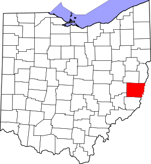 Location within the U.S. state of Ohio | |
 Ohio's location within the U.S. | |
| Coordinates: 40°01′N 80°59′W | |
| Country | |
| State | |
| Founded | 7 September 1801 (created) 7 November 1801 (organized) |
| Named for | "beautiful mountain" in French |
| Seat | St. Clairsville |
| Largest city | Martins Ferry |
| Area | |
| • Total | 541.27 sq mi (1,401.9 km2) |
| • Land | 532.13 sq mi (1,378.2 km2) |
| • Water | 9.14 sq mi (23.7 km2) 1.7%% |
| Population | |
| • Estimate (2019) | 67,006 |
| • Density | 132/sq mi (51/km2) |
| Time zone | UTC−5 (Eastern) |
| • Summer (DST) | UTC−4 (EDT) |
| Congressional district | 6th |
| Website | www |
Belmont County is part of the Wheeling, WV-OH Metropolitan Statistical Area. It is the only Belmont County nationwide.
History
Dille, Ohio, also known as Dilles Bottom, was located across the Ohio River from Moundsville, West Virginia. It was founded by the sons of David Dille (b. 1718) around 1790 and was initially a fort called Fort Dille.
Belmont County was authorized in September 1801 by the Northwest Territorial legislature, with area partitioned from Jefferson and Washington counties.[4] The county would be organized two months later. Its area was reduced in 1810 when area was ceded for the formation of Guernsey and again in 1813 for the formation of Monroe counties. It has retained its boundaries unchanged since 1813. Saint Clairsville was named as the county seat in 1815.
Belmont is the French term for "beautiful mountain". Settlers migrating westward followed Zane's Trace through the county. Later, the National Road was built through the county.
Quakers were among the county's first settlers. Many of these people would become outspoken critics of slavery, including famous abolitionist Benjamin Lundy.
2018 gas well blowout and methane leak
In February 2018, an explosion and blowout in a natural gas well owned by XTO Energy was detected by the Copernicus Sentinel-5P satellite's Tropospheric Monitoring Instrument.
About 30 homes were evacuated near the gas well in York Township, and brine and produced water were discharged into streams flowing into the Ohio River.
The blowout lasted 20 days, releasing more than 50,000 tons of methane, a potent greenhouse gas, into the atmosphere. The blowout leaked more methane than is discharged by most European nations in a year from their oil and gas industries.[6][7][8][9]
Geography
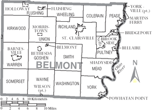
Belmont County lies on the east side of Ohio. Its east border abuts the west border of West Virginia (across the Ohio River). The Ohio flows southward along the county's east line. Captina Creek flows eastward through the lower part of the county, discharging into the Ohio at Powhatan Point, and McMahon Creek also flows eastward through the center of the county, discharging into the Ohio at Bellaire. The county terrain consists of low rolling hills, etched with drainages. All available area is devoted to agriculture.[10] The terrain slopes to the east,[11] with its highest point, Galloway Knob (1,396' or 426m ASL) at 1.2 mile (2 km) southeast of Lamira.[12] The county has a total area of 541.27 sqmi (1492 km²), of which 532.13 sqmi (1378 km²) is land and 9.14 sqmi (23.69 km²) (1.7%) is water.[13]
Adjacent counties
- Harrison County - north
- Jefferson County - northeast
- Ohio County, West Virginia - east
- Marshall County, West Virginia - southeast
- Monroe County - south
- Noble County - southwest
- Guernsey County - west
Major highways
Protected areas
- Barkcamp State Park
- Dysart Woods Natural Monument
- Egypt Valley Wildlife Area[10]
Lakes
- Barnesville Lake
- Barnesville Reservoir #3
- Belmont Lake
- Piedmont Lake (part)[10]
Demographics
| Historical population | |||
|---|---|---|---|
| Census | Pop. | %± | |
| 1810 | 11,097 | — | |
| 1820 | 20,329 | 83.2% | |
| 1830 | 28,627 | 40.8% | |
| 1840 | 30,901 | 7.9% | |
| 1850 | 34,600 | 12.0% | |
| 1860 | 36,398 | 5.2% | |
| 1870 | 39,714 | 9.1% | |
| 1880 | 49,638 | 25.0% | |
| 1890 | 57,413 | 15.7% | |
| 1900 | 60,875 | 6.0% | |
| 1910 | 76,856 | 26.3% | |
| 1920 | 93,193 | 21.3% | |
| 1930 | 94,719 | 1.6% | |
| 1940 | 95,614 | 0.9% | |
| 1950 | 87,740 | −8.2% | |
| 1960 | 83,864 | −4.4% | |
| 1970 | 80,917 | −3.5% | |
| 1980 | 82,569 | 2.0% | |
| 1990 | 71,074 | −13.9% | |
| 2000 | 70,226 | −1.2% | |
| 2010 | 70,400 | 0.2% | |
| Est. 2019 | 67,006 | [14] | −4.8% |
| US Decennial Census[15] 1790-1960[16] 1900-1990[17] 1990-2000[18] 2010-2019[2] | |||
2010 census
As of the 2010 United States Census, there were 70,400 people, 28,679 households, and 18,761 families in the county.[19] The population density was 132.3/sqmi (51.1/km²). There were 32,452 housing units at an average density of 61.0/sqmi (23.55/km²).[20] The racial makeup of the county was 94.0% white, 4.0% black or African American, 0.4% Asian, 0.1% American Indian, 0.2% from other races, and 1.3% from two or more races. Those of Hispanic or Latino origin made up 0.6% of the population.[19] In terms of ancestry, 26.0% were German, 17.9% were Irish, 12.4% were English, 10.1% were Italian, 9.0% were Polish, and 6.2% were American.[21]
Of the 28,679 households, 27.2% had children under the age of 18 living with them, 49.2% were married couples living together, 11.4% had a female householder with no husband present, 34.6% were non-families, and 29.9% of all households were made up of individuals. The average household size was 2.32 and the average family size was 2.85. The median age was 43.4 years.[19]
The median income for a household in the county was $38,320 and the median income for a family was $47,214. Males had a median income of $42,022 versus $26,926 for females. The per capita income for the county was $20,266. About 12.1% of families and 15.2% of the population were below the poverty line, including 24.4% of those under age 18 and 9.1% of those age 65 or over.[22]
2000 census
As of the 2000 United States Census,[23] there were 70,226 people, 28,309 households, and 19,250 families in the county. The population density was 132.0/sqmi (50.96/km²). There were 31,236 housing units at an average density of 58.7/sqmi (22.66/km²). The racial makeup of the county was 94.98% White, 3.64% Black or African American, 0.14% Native American, 0.30% Asian, 0.02% Pacific Islander, 0.16% from other races, and 0.77% from two or more races. 0.39% of the population were Hispanic or Latino of any race. 20.2% were of German, 12.5% Irish, 12.0% American, 10.3% English, 10.2% Italian and 9.0% Polish ancestry according to Census 2000.
There were 28,309 households out of which 28.30% had children under the age of 18 living with them, 53.10% were married couples living together, 11.20% had a female householder with no husband present, and 32.00% were non-families. 28.70% of all households were made up of individuals and 15.10% had someone living alone who was 65 years of age or older. The average household size was 2.37 and the average family size was 2.90.
The county population contained 21.80% under the age of 18, 7.70% from 18 to 24, 27.40% from 25 to 44, 24.90% from 45 to 64, and 18.20% who were 65 years of age or older. The median age was 41 years. For every 100 females there were 96.40 males. For every 100 females age 18 and over, there were 93.60 males.
The median income for a household in the county was $29,714, and the median income for a family was $37,538. Males had a median income of $31,211 versus $19,890 for females. The per capita income for the county was $16,221. About 11.70% of families and 14.60% of the population were below the poverty line, including 20.40% of those under age 18 and 9.80% of those age 65 or over.
Politics
In past decades the voters of Belmont County have usually voted Democratic (18 of the past 22 national elections), but in 2012 and 2016 the county selected the Republican Party candidate.
| Year | Republican | Democratic | Third parties |
|---|---|---|---|
| 2016 | 67.4% 21,108 | 28.0% 8,785 | 4.6% 1,438 |
| 2012 | 52.9% 16,758 | 44.7% 14,156 | 2.4% 774 |
| 2008 | 47.4% 15,422 | 50.1% 16,302 | 2.5% 812 |
| 2004 | 46.8% 15,589 | 52.8% 17,576 | 0.5% 157 |
| 2000 | 41.9% 12,625 | 53.0% 15,980 | 5.1% 1,536 |
| 1996 | 26.8% 8,213 | 57.8% 17,705 | 15.4% 4,721 |
| 1992 | 25.8% 8,614 | 55.4% 18,527 | 18.8% 6,280 |
| 1988 | 38.2% 12,214 | 61.0% 19,515 | 0.8% 244 |
| 1984 | 43.5% 15,170 | 55.8% 19,458 | 0.7% 228 |
| 1980 | 42.5% 13,601 | 52.0% 16,653 | 5.5% 1,770 |
| 1976 | 38.5% 13,550 | 60.1% 21,162 | 1.4% 507 |
| 1972 | 53.6% 17,628 | 45.0% 14,800 | 1.4% 450 |
| 1968 | 31.9% 11,512 | 61.2% 22,056 | 6.9% 2,478 |
| 1964 | 25.6% 9,693 | 74.4% 28,180 | |
| 1960 | 43.3% 18,146 | 56.7% 23,805 | |
| 1956 | 50.3% 19,230 | 49.7% 18,991 | |
| 1952 | 41.7% 17,693 | 58.3% 24,759 | |
| 1948 | 35.8% 13,283 | 62.5% 23,217 | 1.7% 643 |
| 1944 | 39.1% 15,485 | 60.9% 24,093 | |
| 1940 | 38.2% 17,705 | 61.8% 28,618 | |
| 1936 | 31.9% 14,511 | 67.2% 30,545 | 0.9% 425 |
| 1932 | 40.8% 15,029 | 55.0% 20,291 | 4.2% 1,565 |
| 1928 | 60.8% 20,969 | 37.2% 12,807 | 2.0% 692 |
| 1924 | 54.5% 16,378 | 26.9% 8,074 | 18.6% 5,583 |
| 1920 | 50.6% 14,761 | 45.7% 13,347 | 3.7% 1,093 |
| 1916 | 44.2% 7,526 | 46.4% 7,911 | 9.4% 1,609 |
| 1912 | 34.0% 5,267 | 34.9% 5,412 | 31.1% 4,812 |
| 1908 | 48.0% 8,193 | 45.4% 7,750 | 6.6% 1,120 |
| 1904 | 56.8% 8,170 | 33.4% 4,801 | 9.9% 1,425 |
| 1900 | 55.4% 8,217 | 42.1% 6,251 | 2.5% 365 |
| 1896 | 53.7% 7,699 | 44.7% 6,413 | 1.6% 236 |
| 1892 | 48.3% 6,329 | 46.7% 6,123 | 5.0% 657 |
| 1888 | 51.6% 6,615 | 45.0% 5,778 | 3.4% 440 |
| 1884 | 50.8% 6,186 | 47.3% 5,763 | 1.9% 231 |
| 1880 | 50.1% 5,539 | 48.6% 5,379 | 1.3% 143 |
| 1876 | 49.6% 4,976 | 50.0% 5,024 | 0.4% 41 |
| 1872 | 53.8% 4,267 | 46.0% 3,647 | 0.3% 22 |
| 1868 | 50.2% 3,893 | 49.8% 3,862 | |
| 1864 | 49.1% 3,379 | 50.9% 3,503 | |
| 1860 | 41.0% 2,675 | 22.2% 1,450 | 36.7% 2,400 |
| 1856 | 28.4% 1,817 | 44.0% 2,810 | 27.4% 1,753 |
Government
Most of the county's government offices are located in the Belmont County Courthouse.[25] Belmont County has a three-member board of county commissioners who administer and oversee the various county departments, similar to all but two of the 88 Ohio counties. The elected commissioners serve staggered four-year terms. As of 2019, Belmont County's elected commissioners are: Jerry Echemann (R), J.P. Dutton (R), and Josh Meyer (R).[26]
Belmont County's county flag was designed in 1988 by local state official Michael Massa. Local citizens voted in a nationally covered election to choose it from a group of three designs by Massa. The seal (minus a Latin phrase) is featured on the county's flag.[27]
Corrections
Belmont County is served by several detention centers located around St. Clairsville. The Belmont Correctional Institution is located on 158 acres (0.64 km2) between St. Clairsville and Bannock on State Route 331. The facility houses 2,698 inmates as of 2009.[28] The Belmont County Jail in St. Clairsville is located near Belmont College and Ohio University Eastern Campus. The facility contains 144 beds and also houses the county sheriff's offices.[29] The county is also served by Sargus Juvenile Detention Center, a 17-bed facility that also serves surrounding counties.[30] Sargus Center is located next to the county jail.
Education
K-12
Belmont County is served by these local schools:
- Barnesville Exempted Village School District
- Bellaire High School
- Belmont County Educational Service Center
- Bridgeport High School
- Buckeye Local High School
- East Richland Christian School
- Harrison Central High School
- Martins Ferry High School
- Olney Friends School
- Saint Clairsville High School
- Shadyside High School
- Union Local High School
- Powhatan Elementary School in Powhatan Point
Higher education
Communities
Cities
- Martins Ferry
- St. Clairsville (county seat)
Villages
Unincorporated communities
- Alledonia
- Anvil
- Armstrongs Mills
- Badgertown
- Barton
- Blaine
- Boston
- Businessburg
- Captina
- Centerville
- Colerain
- Crescent
- Dilles Bottom
- Egypt
- Fairpoint
- Farmington
- Hendrysburg
- Hunter
- Jacobsburg
- Key
- Lamira
- Lloydsville
- Maynard
- McClainville
- Pleasant Grove
- Riverview
- Sewellsville
- Somerton
- Steinersville
- Stewartsville
- Tacoma
- Temperanceville
- Uniontown
- Warnock
Notable residents
- James E. Boyd (1834-1906), mayor of Omaha and the seventh governor of Nebraska[31]
- William Boyd (1895-1972), film and radio actor, portrayed Western character Hopalong Cassidy from 1935-1954
- Kathy Crumbley (1946-2011), Belmont County Sheriff (first elected female sheriff in USA)[32][33]
- Don Fleming (1937-1963), a graduate of Shadyside High School, played football for the University of Florida and the Cleveland Browns.
- Joey Galloway (1971- ), a graduate of Bellaire High School, played football for Ohio State and in the NFL for 15 years.
- John Havlicek (1940-2019), a graduate of Bridgeport High School, played basketball for Ohio State and the Boston Celtics in the NBA. Elected to Hall of Fame.
- Bushrod Johnson (1817-1880), one of the few Confederate States of America generals born in the North, was born in Belmont County.
- Lance Mehl (1958- ), born in Bellaire. NFL football player
- Stan Olejniczak (1912-1979), born in Neffs. NFL football player
- Wilson Shannon (1802-1877), first native-born governor of Ohio
References
- "Belmont County Flag". Capitol Square Review and Advisory Board. Retrieved January 26, 2015.
- "State & County QuickFacts". United States Census Bureau. Retrieved April 19, 2020.
- "Find a County". National Association of Counties. Archived from the original on May 31, 2011. Retrieved June 7, 2011.
- McKelvey, A. T.. Centennial history of Belmont County, Ohio, and representative citizens. pp. 46-47. Chicago, Biographical Pub. Co. (1903)
- "Belmont County data". Ohio State University Extension Data Center. Retrieved April 28, 2007.
- "Exxon's XTO caps leaking Ohio gas well, 20 days after blowout". Reuters. March 7, 2018. Retrieved December 24, 2019.
- Pandey, Sudhanshu; Gautam, Ritesh; Houweling, Sander; Gon, Hugo Denier van der; Sadavarte, Pankaj; Borsdorff, Tobias; Hasekamp, Otto; Landgraf, Jochen; Tol, Paul; Kempen, Tim van; Hoogeveen, Ruud (December 12, 2019). "Satellite observations reveal extreme methane leakage from a natural gas well blowout". Proceedings of the National Academy of Sciences. 116 (52): 26376–26381. doi:10.1073/pnas.1908712116. ISSN 0027-8424. PMC 6936547. PMID 31843920.
- Falconer, Rebecca (December 17, 2009). "Satellite reveals Ohio gas well blowout to be a massive methane "super-emitter"". Axios. Retrieved December 24, 2019.
- European Space Agency (December 20, 2019). "Massive Methane Leak Visible From Space". SciTechDaily. Retrieved December 24, 2019.
- Belmont County OH - Google Maps (accessed 12 June 2019)
- ""Find an Altitude/Belmont County OH" - Google Maps (accessed 12 June 2019)". Archived from the original on May 21, 2019. Retrieved June 12, 2019.
- Galloway Knob OH (PeakBagger.com, accessed 12 June 2019)
- "2010 Census Gazetteer Files". US Census Bureau. August 22, 2012. Archived from the original on May 4, 2014. Retrieved June 12, 2019.
- "Population and Housing Unit Estimates". Retrieved March 26, 2020.
- "US Decennial Census". US Census Bureau. Retrieved February 7, 2015.
- "Historical Census Browser". University of Virginia Library. Retrieved February 7, 2015.
- Forstall, Richard L., ed. (March 27, 1995). "Population of Counties by Decennial Census: 1900 to 1990". US Census Bureau. Retrieved February 7, 2015.
- "Census 2000 PHC-T-4. Ranking Tables for Counties: 1990 and 2000" (PDF). US Census Bureau. April 2, 2001. Retrieved February 7, 2015.
- "Profile of General Population and Housing Characteristics: 2010 Demographic Profile Data". US Census Bureau. Archived from the original on February 13, 2020. Retrieved December 27, 2015.
- "Population, Housing Units, Area, and Density: 2010 - County". US Census Bureau. Archived from the original on February 13, 2020. Retrieved December 27, 2015.
- "Selected Social Characteristics in the US – 2006-2010 American Community Survey 5-Year Estimates". US Census Bureau. Archived from the original on February 13, 2020. Retrieved December 27, 2015.
- "Selected Economic Characteristics – 2006-2010 American Community Survey 5-Year Estimates". US Census Bureau. Archived from the original on February 13, 2020. Retrieved December 27, 2015.
- "U.S. Census website". US Census Bureau. Retrieved January 31, 2008.
- Leip, David. "Atlas of US Presidential Elections". uselectionatlas.org. Retrieved May 1, 2018.
- "Ohio Secretary of State 2006 Unofficial Election Statistics". Archived from the original on April 9, 2007. Retrieved April 5, 2007.
- "Belmont County Board of County Commissioners". Belmont County Ohio Homepage. Retrieved May 7, 2019.
- Ohio County Flags: Belmont County, The Ohio Channel, 2007. Accessed September 11, 2007.
- "Belmont Correctional Institution". state.oh.us. Archived from the original on September 1, 2009. Retrieved August 20, 2009.
- "Belmont County Sheriff's Office".
- "Belmont County Juvenile Court". belmontcountyjuvenilecourt.com. Archived from the original on July 7, 2011. Retrieved August 20, 2009.
- "Kansas Governor Walter Roscoe Stubbs". National Governors Association. Archived from the original on June 14, 2012. Retrieved September 29, 2012.
- "Former Sheriff Dies" (accessed 12 June 2019)
- "Katherine Crumbley" (accessed 12 June 2019)
Further reading
- Thomas William Lewis, History of Southeastern Ohio and the Muskingum Valley, 1788-1928. In Three Volumes. Chicago: S.J. Clarke Publishing Co., 1928.
External links
| Wikimedia Commons has media related to Belmont County, Ohio. |
- Belmont County Government's Web site
- Belmont County Economic Development
- Belmont County Port Authority
Places adjacent to Belmont County, Ohio | |
|---|---|
Municipalities and communities of Belmont County, Ohio, United States | ||
|---|---|---|
| Cities | Map of Ohio highlighting Belmont County | |
| Villages | ||
| Townships | ||
| CDPs | ||
| Unincorporated communities |
| |
| Ghost town | ||
| Footnotes | ‡This populated place also has portions in an adjacent county or counties | |
.svg.png)
| Authority control |
|
|---|