Lewis County, Kentucky
Lewis County is a county located in the U.S. state of Kentucky. As of the 2010 census, the population was 13,870.[1] Its county seat is Vanceburg.[2]
Lewis County | |
|---|---|
 Lewis County courthouse in Vanceburg | |
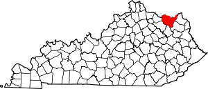 Location within the U.S. state of Kentucky | |
 Kentucky's location within the U.S. | |
| Coordinates: 38°32′N 83°23′W | |
| Country | |
| State | |
| Founded | December 2, 1806 |
| Named for | Meriwether Lewis |
| Seat | Vanceburg |
| Largest city | Vanceburg |
| Area | |
| • Total | 495 sq mi (1,280 km2) |
| • Land | 483 sq mi (1,250 km2) |
| • Water | 13 sq mi (30 km2) 2.5%% |
| Population | |
| • Estimate (2018) | 13,257 |
| • Density | 29/sq mi (11/km2) |
| Time zone | UTC−5 (Eastern) |
| • Summer (DST) | UTC−4 (EDT) |
| Congressional district | 4th |
| Website | lewiscounty |
History
The area presently bounded by Kentucky state lines was a part of the U.S. State of Virginia, known as Kentucky County when the British colonies separated themselves in the American Revolutionary War. In 1780, the Virginia legislature divided the previous Kentucky County into three smaller units: Fayette, Jefferson, and Lincoln. In 1791, this area was separated into the State of Kentucky; it became effective on June 1, 1792. From that time, the original three counties were divided several times. A portion of Fayette County was split off as Bourbon County in 1785; a portion of Bourbon was split off as Mason County in 1788; in 1806 the present Lewis County was split off from Mason. The new county was named for Meriwether Lewis.[3][4][5]
The county's hilly country, heavily forested, has produced some of the nation's best oak lumber. Lumbering has been the county's principal economic activity from the start.
The county's elevation ranges from 485 to 1400 feet above sea level.
Geography
According to the U.S. Census Bureau, the county has a total area of 495 square miles (1,280 km2), of which 483 square miles (1,250 km2) is land and 13 square miles (34 km2) (2.5%) is water.[6] The county's northern border with Ohio is formed by the Ohio River. Its border with the river is the longest of all the Kentucky counties.[7]
Adjacent counties
- Adams County, Ohio (north)
- Scioto County, Ohio (northeast)
- Greenup County (east)
- Carter County (southeast)
- Rowan County (south)
- Fleming County (southwest)
- Mason County (west)
National protected area
Demographics
| Historical population | |||
|---|---|---|---|
| Census | Pop. | %± | |
| 1810 | 2,357 | — | |
| 1820 | 3,973 | 68.6% | |
| 1830 | 5,229 | 31.6% | |
| 1840 | 6,306 | 20.6% | |
| 1850 | 7,202 | 14.2% | |
| 1860 | 8,361 | 16.1% | |
| 1870 | 9,115 | 9.0% | |
| 1880 | 13,154 | 44.3% | |
| 1890 | 14,803 | 12.5% | |
| 1900 | 17,868 | 20.7% | |
| 1910 | 16,887 | −5.5% | |
| 1920 | 15,829 | −6.3% | |
| 1930 | 14,315 | −9.6% | |
| 1940 | 15,686 | 9.6% | |
| 1950 | 13,520 | −13.8% | |
| 1960 | 13,115 | −3.0% | |
| 1970 | 12,355 | −5.8% | |
| 1980 | 14,545 | 17.7% | |
| 1990 | 13,029 | −10.4% | |
| 2000 | 14,092 | 8.2% | |
| 2010 | 13,870 | −1.6% | |
| Est. 2018 | 13,257 | [8] | −4.4% |
| U.S. Decennial Census[9] 1790-1960[10] 1900-1990[11] 1990-2000[12] 2010-2013[1] | |||
As of the census[13] of 2000, there were 14,092 people, 5,422 households, and 4,050 families residing in the county. The population density was 29 per square mile (11/km2). There were 6,173 housing units at an average density of 13 per square mile (5.0/km2). The racial makeup of the county was 98.92% White, 0.21% Black or African American, 0.21% Native American, 0.03% Asian, 0.09% from other races, and 0.55% from two or more races. 0.44% of the population were Hispanic or Latino of any race.
There were 5,422 households out of which 35.10% had children under the age of 18 living with them, 60.40% were married couples living together, 9.70% had a female householder with no husband present, and 25.30% were non-families. 22.50% of all households were made up of individuals and 10.00% had someone living alone who was 65 years of age or older. The average household size was 2.56 and the average family size was 2.98.
In the county, the population was spread out with 25.30% under the age of 18, 9.10% from 18 to 24, 29.40% from 25 to 44, 23.70% from 45 to 64, and 12.50% who were 65 years of age or older. The median age was 36 years. For every 100 females, there were 99.00 males. For every 100 females age 18 and over, there were 97.00 males.
The median income for a household in the county was $22,208, and the median income for a family was $26,109. Males had a median income of $25,522 versus $18,764 for females. The per capita income for the county was $12,031. About 23.50% of families and 28.50% of the population were below the poverty line, including 36.40% of those under age 18 and 21.30% of those age 65 or over.
Over forty percent of this county gets some kind of government benefit.[14]
Politics
Lewis County is one of the most Republican leaning counties in Kentucky. The last Democrat to win the county in a presidential election was Samuel J. Tilden in 1876.[15]
| Year | Republican | Democratic | Third parties |
|---|---|---|---|
| 2016 | 82.4% 4,363 | 14.8% 785 | 2.8% 150 |
| 2012 | 69.7% 3,326 | 28.1% 1,342 | 2.1% 101 |
| 2008 | 67.1% 3,213 | 31.5% 1,510 | 1.4% 68 |
| 2004 | 68.9% 3,778 | 30.4% 1,667 | 0.7% 39 |
| 2000 | 70.4% 3,217 | 28.3% 1,293 | 1.3% 58 |
| 1996 | 54.1% 2,365 | 32.4% 1,415 | 13.5% 590 |
| 1992 | 50.8% 2,493 | 34.9% 1,713 | 14.2% 698 |
| 1988 | 66.2% 3,108 | 33.4% 1,568 | 0.4% 20 |
| 1984 | 69.6% 3,445 | 30.0% 1,484 | 0.4% 18 |
| 1980 | 63.8% 2,802 | 35.1% 1,543 | 1.1% 48 |
| 1976 | 55.0% 2,383 | 44.5% 1,929 | 0.5% 20 |
| 1972 | 71.6% 3,124 | 27.5% 1,200 | 0.9% 41 |
| 1968 | 64.8% 2,760 | 23.9% 1,017 | 11.3% 480 |
| 1964 | 51.9% 2,300 | 47.7% 2,230 | 0.4% 17 |
| 1960 | 69.4% 3,816 | 30.6% 1,682 | 0.0% 0 |
| 1956 | 67.7% 3,333 | 32.2% 1,585 | 0.2% 9 |
| 1952 | 67.9% 3,317 | 31.8% 1,556 | 0.3% 15 |
| 1948 | 64.7% 2,708 | 34.6% 1,449 | 0.7% 30 |
| 1944 | 69.4% 3,275 | 30.4% 1,434 | 0.2% 8 |
| 1940 | 64.2% 3,371 | 35.8% 1,878 | 0.0% 0 |
| 1936 | 61.9% 3,255 | 37.8% 1,985 | 0.3% 17 |
| 1932 | 55.9% 3,212 | 43.3% 2,488 | 0.8% 48 |
| 1928 | 78.4% 4,077 | 21.5% 1,120 | 0.1% 6 |
| 1924 | 65.1% 3,067 | 30.7% 1,447 | 4.1% 195 |
| 1920 | 71.8% 4,186 | 26.6% 1,550 | 1.6% 91 |
| 1916 | 62.7% 2,324 | 34.4% 1,276 | 2.9% 109 |
| 1912 | 34.5% 1,185 | 29.6% 1,017 | 35.9% 1,231[17] |
Education

The residents of Lewis County are served by the Lewis County Schools school district. There are 4 elementary schools within the county, 1 middle school, and 1 high school. The elementary schools are as follows: Lewis County Central Elementary, located in Vanceburg, Garrison Elementary, located east of Vanceburg in the town of Garrison, Tollesboro Elementary, located west of Vanceburg in the town of Tollesboro, and Laurel Elementary, located south east of Vanceburg in the Laurel area of Lewis County. Upon entering 7th grade all 7th grade students attend Lewis County Middle School located west of Vanceburg on KY 10. LCMS hosts two grade levels, 7th and 8th. Upon completing 8th grade students attend Lewis County High School, which sets adjacent to the middle school. LCHS hosts grades 9-12 and was a nationally distinguished school in 2015, 2016, and 2018. Lewis County Middle School and Lewis County High School are located west of Vanceburg on KY 10, the AA Highway.
Elementary Schools:
- Lewis County Central Elementary School, Vanceburg. Mascot-Lions, Colors-Royal blue, red, and white.
- Garrison Elementary School, Garrison. Mascot-Patriots, Colors-Red, black, and white.
- Tollesboro Elementary School, Tollesboro. Mascot-Wildcats, Colors-Royal blue, yellow, and white.
- Laurel Elementary School, Laurel. Mascot-Bombers, Colors-Kelly green and white.
Middle Schools:
- Lewis County Middle School, Vanceburg. Mascot-Lions, Colors-Royal blue, red, and white.
High Schools:
- Lewis County High School, Vanceburg. Mascot-Lions, Colors-Royal blue, red, and white.
Closed Schools:
- Tollesboro High School, Tollesboro. Closed in 1994 due to low enrollment numbers and loss of state funding. Tollesboro High students then had to attend Lewis County High School. This was an issue that caused controversy within the county as Tollesboro High School and Lewis County High School had a long-standing, bitter rivalry with one another. Tollesboro officials and residents claimed that the closure of the school by the Lewis County Board of Education was not justified. Some residents went as far as to send their children to the schools of surrounding counties, such as Mason Co. and Fleming Co. However, with time the controversy died down and is now non-existent. The main school building which housed offices, class rooms, etc. as well as the Field Hall, which contained the gymnasium for the school still stand today. They set just off of KY Route 57 near the intersection with old highway 10. The building was later used as the Tollesboro Christian Academy, however that organization was short lived and is now defunct.
- Laurel High School, Laurel. The building which housed the Laurel High School burned in the late 1930s. The building was made of local stone which was largely undamaged by the fire, so the exterior of the building could have been reused. However, the interior was burnt beyond repair. High School students of the Laurel area then had to attend Lewis County High School, where they still go to this day. The building sat just off of the intersection of KY Route 59 and highway 1068 (near Laurel Point). The remnants of the building are still visible today.
Communities
Census-designated place
Other unincorporated places
- Alburn
- Awe
- Black Oak
- Beechy Creek
- Buena Vista
- Burtonville
- Cabin Creek
- Camp Dix
- Carrs
- Charters
- Clarksburg
- Cottageville
- Covedale
- Crum
- Emerson
- Epworth
- Esculapia Springs
- Fearis
- Firebrick
- Fruit
- Glenn
- Glenn Springs
- Gun Powder Gap
- Harris
- Head of Grassy
- Heselton
- Irwin
- Jacktown
- Kinniconick
- Kirkville
- Laurel
- Libbie
- Martin
- McDowell Creek
- McKenzie
- Montgomery Creek
- Nashtown
- Noah
- Oak Ridge
- Pence
- Petersville
- Poplar Flat
- Quicks Run
- Randville
- Records
- Rexton
- Ribolt
- Rugless
- Saint Paul
- Salt Lick
- Sand Hill
- Stricklett
- Sullivan
- Tannery
- Teutonia
- Thor
- Tollesboro
- Trinity (Trinity Station)
- Upper Bruce
- Valley
- Wadsworth
Notable people
- Thomas Marshall (1793–1853) – United States Army general of the Mexican–American War.
- The founder of "Pillar of Fire Church" and KKK advocate Alma Bridwell White was born there.
- Thomas Massie, Current Congressman, Kentucky's 4th Congressional District
- Ralph Davis, (Ralph E. Davis Jr.) University of Cincinnati Basketball. Started on two NCAA Final Four teams for the Bearcats. Went on to play professional basketball in the American Basketball Association (ABA) for the Cincinnati Royals, a Pre-NBA merger franchise which is now the Sacramento Kings.
- Faith Esham, Performer (opera) and recitalist
- Thomas H. Paynter, United States Senator 1907-13
- George M. Thomas (American politician), (November 23, 1828 – January 7, 1914) Member of the U.S. House of Representatives from Kentucky's 9th district: In office March 4, 1887 – March 3, 1889. Member of the Kentucky House of Representatives: In office 1859–1863, 1872–1873. Commonwealth's Attorney for the tenth judicial district 1862-1868. Was elected Lewis county judge in 1868. Republican candidate for Lieutenant Governor of Kentucky in 1871. Circuit Judge of the fourteenth judicial district from 1874 to 1880 and United States District Attorney from 1881 to 1885. Elected as a Republican to the Fiftieth Congress (March 4, 1887 – March 3, 1889). Was appointed Solicitor of Internal Revenue by President William McKinley on May 20, 1897, and served until May 31, 1901.
References
- "State & County QuickFacts". United States Census Bureau. Archived from the original on June 7, 2011. Retrieved March 6, 2014.
- "Find a County". National Association of Counties. Retrieved June 7, 2011.
- "Lewis County". The Kentucky Encyclopedia. 2000. Retrieved August 22, 2014.
- The Register of the Kentucky State Historical Society, Vol. 1. Kentucky State Historical Society. 1903. p. 36.
- Collins, Lewis (1877). History of Kentucky. p. 464.
- "2010 Census Gazetteer Files". United States Census Bureau. August 22, 2012. Archived from the original on August 12, 2014. Retrieved August 17, 2014.
- Commonwealth of Kentucky Lewis County
- "Population and Housing Unit Estimates". Retrieved July 29, 2019.
- "U.S. Decennial Census". United States Census Bureau. Retrieved August 17, 2014.
- "Historical Census Browser". University of Virginia Library. Retrieved August 17, 2014.
- "Population of Counties by Decennial Census: 1900 to 1990". United States Census Bureau. Retrieved August 17, 2014.
- "Census 2000 PHC-T-4. Ranking Tables for Counties: 1990 and 2000" (PDF). United States Census Bureau. Retrieved August 17, 2014.
- "U.S. Census website". United States Census Bureau. Retrieved January 31, 2008.
- The Geography of Government Benefits
- County Voting Map
- Leip, David. "Dave Leip's Atlas of U.S. Presidential Elections". uselectionatlas.org. Retrieved July 3, 2018.
- The leading "other" candidate, Progressive Theodore Roosevelt, received 1,063 votes, while Socialist candidate Eugene Debs received 168 votes.
External links
| Wikimedia Commons has media related to Lewis County, Kentucky. |
Municipalities and communities of Lewis County, Kentucky, United States | ||
|---|---|---|
| Cities | Location of Lewis County, Kentucky | |
| CDP | ||
| Other unincorporated communities | ||
| Authority control |
|
|---|