Weirton, West Virginia
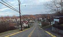
Weirton (/ˈwirtən/) is a city in Brooke and Hancock counties in the U.S. state of West Virginia. Located primarily in Hancock County, the city lies in the northern portions of the state's Northern Panhandle region. As of the 2010 census, the city's population was 19,746. Weirton is a principal city of the Weirton–Steubenville, WV-OH Metropolitan Statistical Area, which had a 2010 population of 124,454 residents. Additionally, Weirton is part of Greater Pittsburgh, the 20th largest combined statistical area in the United States with a 2019 estimated population of 2,635,228.
Weirton, West Virginia | |
|---|---|
| City of Weirton | |
 Peter Tarr Furnace Site, c. 1790 | |
| Nickname(s): "Gateway To The Valley" | |
 Location of Weirton in Hancock and Brooke Counties, West Virginia. | |
| Coordinates: 40°25′N 80°35′W | |
| Country | United States |
| State | West Virginia |
| Counties | Hancock, Brooke |
| Area | |
| • City | 19.27 sq mi (49.91 km2) |
| • Land | 18.05 sq mi (46.76 km2) |
| • Water | 1.22 sq mi (3.15 km2) |
| Elevation | 755 ft (230 m) |
| Population | |
| • City | 19,746 |
| • Estimate (2019)[3] | 18,266 |
| • Density | 1,021.82/sq mi (394.54/km2) |
| • Urban | 70,889 (US: 389th) |
| • Metro | 121,336 (US: 319th) |
| Time zone | UTC−5 (Eastern (EST)) |
| • Summer (DST) | UTC−4 (EDT) |
| ZIP code | 26062 |
| Area code(s) | 304 |
| FIPS code | 54-85156 |
| GNIS feature ID | 1555932[4] |
| Website | Facebook.com/Weirton cityofweirton.com |
History
The small village called Holliday's Cove lanes — which is now most of downtown Weirton — was founded in 1793. (It eventually lost the apostrophe.) In 1909, Ernest T. Weir arrived from neighboring Pittsburgh and built a steel mill, later known as the Weirton Steel Corporation, just north of Holliday's Cove.[5] An unincorporated settlement called Weirton grew up around the mill that, by 1940, was said to be the largest unincorporated city in the United States. By then Hollidays Cove and two other outlying areas, Weirton Heights and Marland Heights, which as their names suggest were on hilltops or ridges surrounding the "Weir–Cove" area, had also incorporated.
Hollidays Cove Fort was a Revolutionary War fortification constructed in 1774 by soldiers from Ft. Pitt. It was located in what is now downtown Weirton, along Harmons Creek (named for Harmon Greathouse), about three miles from its mouth on the Ohio River. It was commanded by Colonel Andrew Van Swearingen (1741–1793) and later by his son-in-law, Captain Samuel Brady (1756–1795), the famous leader of Brady's Rangers. In 1779, over 28 militia were garrisoned at Hollidays Cove. Two years earlier, Colonel Van Swearingen led a dozen soldiers by longboat down the Ohio to help rescue the inhabitants of Ft. Henry in Wheeling in a siege by the British and Indian tribes in 1777. That mission was memorialized in a WPA-era mural painted on the wall of the Cove Post Office by Charles S. Chapman (1879–1962). The mural features Col. John Bilderback, who later gained infamy as the leader of the massacre of the Moravian Indians in Gnadenhutten in 1782.[6]
On July 1, 1947, all of these areas — Hollidays Cove, Marland Heights, Weirton Heights, and unincorporated Weirton — merged and formed the city of Weirton as it currently exists. Thomas E. Millsop, the head of the Weirton Steel division of the other Ernest T. Weir company, National Steel Corporation, was elected as the city's first mayor. The city charter was approved by voters in 1950.
Weirton is also home to the Weirton Steel Corporation which was once a fully integrated steel mill employing over 12,000 people. It was the largest private employer and the largest taxpayer in West Virginia. This is no longer true. Due to reorganization of the steel industry, not only within the United States but worldwide, the Weirton plant, now part of the international giant Arcelor Mittal, currently operates only the tin-plating section of the mill (though still one of the country's largest tin-plate makers), with only 800 workers. During the early 1980s the employees of Weirton Steel endeavored to purchase the mill from National Steel Corporation as the largest ESOP (Employee Stock Ownership Program) in the nation, saving the mill from bankruptcy.[7]
Some civic leaders are attempting to attract businesses and homeowners from the neighboring Pittsburgh metropolitan area, marketing Weirton as a bedroom community, taking advantage of the close proximity to the Pittsburgh International Airport and major interstates as well as the reputation of the gay-friendly Ohio Valley.
Weirton is home to a number of sites on the National Register of Historic Places including: Johnston-Truax House, Marland Heights Park and Margaret Manson Weir Memorial Pool, People's Bank, Dr. George Rigas House, and the Peter Tarr Furnace Site.[8]
Geography
The city of Weirton is located at 40°25′N 80°35′W (40.41, −80.58).[9] It extends from the Ohio border on the west to the Pennsylvania border on the east at a point where the northern extension of West Virginia is five miles across. Therefore, it is one of only three cities in the United States that borders two other states on two sides, and its own state on the other two sides, the others being Hancock, Maryland and Pittsburg, New Hampshire.
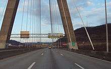
Weirton is across the Ohio River from Steubenville, Ohio, and about 35 miles west of Pittsburgh, Pennsylvania, along U.S. Route 22. Pittsburgh International Airport is less than 30 miles away. With the opening of Pennsylvania Route 576 from US 22 to the airport in October 2006, the highway distance to the airport has decreased to about 20 miles.
According to the United States Census Bureau, the city has a total area of 19.26 square miles (49.88 km2), of which, 18.05 square miles (46.75 km2) is land and 1.21 square miles (3.13 km2) is water.[10]
Surrounding areas
Weirton has three borders, including the cities of Follansbee to the south and New Cumberland to the north and the Pennsylvania/Washington County township of Hanover to the east. Weirton is also adjacent to Steubenville, Ohio and is directly accessible via the Veterans' Memorial Bridge (U.S. Route 22).
Climate
Weirton has a humid continental climate (Köppen Dfa), with warm summers and chilly to cold winters.
| Climate data for Weirton, West Virginia | |||||||||||||
|---|---|---|---|---|---|---|---|---|---|---|---|---|---|
| Month | Jan | Feb | Mar | Apr | May | Jun | Jul | Aug | Sep | Oct | Nov | Dec | Year |
| Record high °F (°C) | 75 (24) |
77 (25) |
84 (29) |
89 (32) |
93 (34) |
98 (37) |
102 (39) |
100 (38) |
101 (38) |
91 (33) |
85 (29) |
77 (25) |
102 (39) |
| Average high °F (°C) | 36 (2) |
40 (4) |
51 (11) |
62 (17) |
72 (22) |
80 (27) |
83 (28) |
82 (28) |
75 (24) |
64 (18) |
52 (11) |
41 (5) |
62 (16) |
| Average low °F (°C) | 20 (−7) |
23 (−5) |
30 (−1) |
39 (4) |
49 (9) |
58 (14) |
63 (17) |
62 (17) |
55 (13) |
43 (6) |
34 (1) |
25 (−4) |
42 (5) |
| Record low °F (°C) | −22 (−30) |
−8 (−22) |
−1 (−18) |
15 (−9) |
24 (−4) |
34 (1) |
43 (6) |
40 (4) |
33 (1) |
19 (−7) |
−1 (−18) |
−14 (−26) |
−22 (−30) |
| Average precipitation inches (mm) | 2.85 (72) |
2.46 (62) |
3.29 (84) |
3.20 (81) |
4.11 (104) |
4.37 (111) |
4.26 (108) |
3.84 (98) |
3.26 (83) |
2.53 (64) |
3.38 (86) |
3.00 (76) |
40.55 (1,029) |
| Source: weather.com[11] | |||||||||||||
- Annual Average High Temperatures: 82 °F (summer) 40 °F (winter)
- Annual Average Low Temperatures 60 °F (summer) 25 °F (winter)
- Highest Recorded Temperature: 102 °F (1988)
- Lowest Recorded Temperature: -22 °F (1994)
- Warmest Month: July
- Coolest Month: January
- Highest Precipitation: June
- Annual Precipitation: 40.55 inches
Demographics
| Historical population | |||
|---|---|---|---|
| Census | Pop. | %± | |
| 1950 | 24,005 | — | |
| 1960 | 28,201 | 17.5% | |
| 1970 | 27,131 | −3.8% | |
| 1980 | 24,736 | −8.8% | |
| 1990 | 22,124 | −10.6% | |
| 2000 | 20,411 | −7.7% | |
| 2010 | 19,746 | −3.3% | |
| Est. 2019 | 18,266 | [3] | −7.5% |
| U.S. Decennial Census[12] 2018 Estimate[13] | |||
By 2011, the city and its two counties had attracted the attention of the New York Times which noted the town was dwindling in population. The article reported that Brooke County had just 71 live births for every 100 deaths and that Hancock County was in similar straits. This has led, the article claimed, to a reduction in civic institutions.[14]
2010 census
As of the census[2] of 2010, there were 19,746 people, 8,839 households, and 5,507 families living in the city. The population density was 1,094.0 inhabitants per square mile (422.4/km2). There were 9,645 housing units at an average density of 534.3 per square mile (206.3/km2). The racial makeup of the city was 93.7% White, 3.9% African American, 0.1% Native American, 0.5% Asian, 0.2% from other races, and 1.6% from two or more races. Hispanic or Latino of any race were 1.0% of the population.
There were 8,839 households, of which 24.8% had children under the age of 18 living with them, 44.8% were married couples living together, 13.0% had a female householder with no husband present, 4.5% had a male householder with no wife present, and 37.7% were non-families. 32.9% of all households were made up of individuals, and 15.1% had someone living alone who was 65 years of age or older. The average household size was 2.22 and the average family size was 2.78.
The median age in the city was 46 years. 19.4% of residents were under the age of 18; 6.3% were between the ages of 18 and 24; 23% were from 25 to 44; 30.8% were from 45 to 64; and 20.6% were 65 years of age or older. The gender makeup of the city was 47.3% male and 52.7% female.
2000 census
As of the census[15] of 2000, there were 20,411 people, 8,958 households, and 5,885 families living in the city. The population density was 1,142.2 people per square mile (441.0/km2). There were 9,546 housing units at an average density of 534.2 per square mile (206.3/km2). The racial makeup of the city was 94.52% White, 3.86% African American, 0.11% Native American, 0.59% Asian, 0.01% Pacific Islander, 0.14% from other races, and 0.77% from two or more races. Hispanic or Latino of any race were 0.68% of the population.
There were 8,958 households, out of which 23.8% had children under the age of 18 living with them, 51.4% were married couples living together, 10.6% had a female householder with no husband present, and 34.3% were non-families. 30.8% of all households were made up of individuals, and 15.9% had someone living alone who was 65 years of age or older. The average household size was 2.25 and the average family size was 2.79.
In the city, the population was spread out, with 19.2% under the age of 18, 6.6% from 18 to 24, 26.5% from 25 to 44, 25.4% from 45 to 64, and 22.3% who were 65 years of age or older. The median age was 44 years. For every 100 females, there were 88.6 males. For every 100 females age 18 and over, there were 85.6 males.
The median income for a household in the city was $35,212, and the median income for a family was $42,466. Males had a median income of $37,129 versus $19,745 for females. The per capita income for the city was $18,853. About 8.0% of families and 10.3% of the population were below the poverty line, including 14.0% of those under age 18 and 7.9% of those age 65 or over.
Government
The following people have been elected Mayor of Weirton since the city's incorporation in 1947:
| Thomas E. Millsop | 1947–1955 |
| Samuel Kusic | 1955–1959 |
| David T. Frew | 1959–1963 |
| Frank A. Rybka | 1963–1971 |
| Mike A. Andochick, Jr. | 1971–1979 |
| Donald T. Mentzer | 1979–1987 |
| Edwin J. Bowman | 1987–1995 |
| Dean M. Harris | 1995–2003 |
| William M. Miller | 2003–2007 |
| Mark Harris | 2007–2011 |
| George Kondik | 2011–2015 |
| Harold "Bubba" Miller | 2015–present |
Police
There have been three fatal shootings by police officers in the history of the Weirton department.[16] The third, in 2016, was a case of suicide by cop. The first officer on the scene recognized the situation, determined that the situation posed no immediate threat, and started talking to the distressed citizen, who was holding an unloaded gun and telling the officer to "Just shoot me".[16] An officer who arrived subsequently shot the man dead on his fourth attempt, less than 10 seconds after arriving on the scene.[16]
The police department fired the first officer for not killing the man first.[16] The police chief said in sworn testimony that although he had fired the officer for not shooting the man soon enough, the department's policy prohibits officers from shooting people whom they believe do not pose a threat.[16] Shortly after this admission that the officer was fired for correctly following the department policy on the legitimate use of force, the city settled a lawsuit for wrongful termination.[16]
Economy
Historically, Weirton's economy, as well as that of the region, was dominated by the steel industry, with the biggest employer being ArcelorMittal.
Over the years as the steel industry declined, the local economy has become more diversified, with retail services and medical services recording the largest increases.
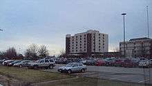
Weirton Medical Center is a large 238 bed hospital that services patients from all over the region, and is one of the city's largest employers today employing over 1,000 people.
Due to the area's close proximity to Pittsburgh, Pennsylvania, there is also a growing number of workers who work in Pittsburgh and commute from Weirton.
Popular culture
Weirton was the subject of a photo essay, "Weir's Weirton," in the Life issue of September 13, 1937. The issue's front cover featured a portrait of Ernest Tener Weir.
Weirton has attracted the attention of Hollywood filmmakers and writers on several occasions:
- Weirton was one of several Ohio Valley towns that served as film locations for the acclaimed 1978 film, The Deer Hunter, starring Robert De Niro and Meryl Streep.
- Six years later it served as the primary location for filming of Reckless starring Aidan Quinn and Daryl Hannah.
- The movie Super 8 was filmed in downtown Weirton, as well as many other places throughout the town, in late September to mid October 2010. The town stood in for the fictional town of Lillian, Ohio.
- Disney featured Weirton briefly in its documentary, America's Heart and Soul. During the excerpt, employees of Weirton Steel discuss their concerns with foreign imports and what it is doing to the size of their mill.
- Weirton was also the inspiration and guidance in the 1989 book No Star Nights. According to the author biography included in the book, author Anna Smucker drew upon her memories growing up in Weirton for a tale about childhood spent in an industrial town.[17]
- In the novel The Egyptian Cross Mystery, Ellery Queen spent some time in Weirton while investigating a murder in the small village of Arroyo, West Virginia.
- Weirton is mentioned in the song by Daniel Johnston, Natalie, Queen of Weirton
Notable people
- James J. Andrews - Union spy during the Civil War (Hollidays Cove)
- Thais Blatnik - journalist and politician
- Big Bully Busick - professional wrestler
- Bob Gain - football player, Cleveland Browns ('52–'64); 1950 Outland Trophy winner (U. Kentucky)
- Jerry A. Hausman - noted economist at MIT and developer of the Hausman specification test
- Bob Jeter - football player, Green Bay Packers and Chicago Bears, 3-time NFL champion
- Gary Jeter - football player, New York Giants, Los Angeles Rams and New England Patriots
- Kevin Miller - football player, Minnesota Vikings and Birmingham Stallions
- Mike Rodak - football player, Cleveland Rams, Detroit Lions, and Pittsburgh Steelers
- Karen Staley - singer-songwriter
- Ernest T. Weir - founder, National Steel Corporation
- Ronald Robert Williams - "Fritz" basketball player, West Virginia University, San Francisco Warriors, Milwaukee Bucks, and Los Angeles Lakers.
- Quincy Wilson - football player, West Virginia University, Cincinnati Bengals
See also
- List of cities and towns along the Ohio River
- Veterans Memorial Bridge
- Market Street Bridge (Steubenville)
- National Register of Historic Places listings in Hancock County, West Virginia
References
- "2018 U.S. Gazetteer Files". United States Census Bureau. Retrieved Feb 16, 2020.
- "U.S. Census website". United States Census Bureau. Retrieved 2013-01-24.
- "Population and Housing Unit Estimates". Retrieved May 21, 2020.
- "US Board on Geographic Names". United States Geological Survey. 2007-10-25. Retrieved 2008-01-31.
- "Filming of 'Super 8' creates a buzz in Weirton, W.Va". postgazette.com. Retrieved 28 March 2018.
- Every Home a Fort, Every Man a Warrior; Michael Edward Nogay (Tri-State Publishing Co.: 2009) ISBN 978-0-578-01862-1.
- Fundis, Lois Alete (1992). "Weirton History: A SHORT HISTORY OF THE WEIRTON AREA". Mary H. Weir Public Library, Weirton, West Virginia. Retrieved 2008-10-30. Published since 2004-10-26.
- "National Register Information System". National Register of Historic Places. National Park Service. March 13, 2009.
- "US Gazetteer files: 2010, 2000, and 1990". United States Census Bureau. 2011-02-12. Retrieved 2011-04-23.
- "US Gazetteer files 2010". United States Census Bureau. Retrieved 2013-01-24.
- "Weather.com: Weather Channel Historical Weather for Weirton, West Virginia, United States of America". Retrieved December 17, 2010.
- United States Census Bureau. "Census of Population and Housing". Retrieved August 27, 2013.
- "Population Estimates". United States Census Bureau. Retrieved June 8, 2018.
- "With Death Outpacing Birth, a County Slows to a Shuffle", by Sabrina Tavernise and Robert Gebeloff, New York Times, 7 May 2011
- "U.S. Census website". United States Census Bureau. Retrieved 2008-01-31.
- Sexton, Joe (2018-11-29). "What Happened When A White Cop Decided Not to Shoot a Black Man". ProPublica. Retrieved 2018-12-02.
- Johnson, Anna Egan Smucker ; paintings by Steve (1994). No star Nights (1st Dragonfly Books ed.). New York: Knopf. ISBN 0-679-86724-4.
External links
- City of Weirton
- Weirton Daily, local newspaper
- History of Weirton
Municipalities and communities of Brooke County, West Virginia, United States | ||
|---|---|---|
| Cities | 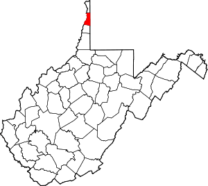 Map of West Virginia highlighting Brooke County | |
| Town | ||
| Villages | ||
| CDP | ||
| Unincorporated communities | ||
| Footnotes | ‡This populated place also has portions in an adjacent county or counties | |
Municipalities and communities of Hancock County, West Virginia, United States | ||
|---|---|---|
| Cities | 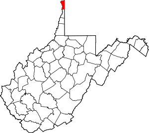 Map of West Virginia highlighting Hancock County | |
| CDP | ||
| Unincorporated communities | ||
| Footnotes | ‡This populated place also has portions in an adjacent county or counties | |

| Authority control |
|
|---|