Athalia, Ohio
Athalia is a village in Lawrence County, Ohio, United States, along the Ohio River. The population was 373 at the 2010 census.
Athalia, Ohio | |
|---|---|
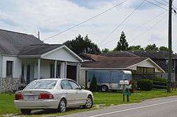 Houses on Market Street | |
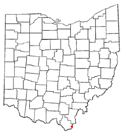 Location of Athalia, Ohio | |
 Location of Athalia in Lawrence County | |
| Coordinates: 38°30′46″N 82°18′25″W | |
| Country | United States |
| State | Ohio |
| County | Lawrence |
| Area | |
| • Total | 0.69 sq mi (1.79 km2) |
| • Land | 0.69 sq mi (1.79 km2) |
| • Water | 0 sq mi (0 km2) |
| Elevation | 554 ft (169 m) |
| Population | |
| • Total | 373 |
| • Estimate (2019[4]) | 354 |
| • Density | 540.6/sq mi (208.7/km2) |
| Time zone | UTC-5 (Eastern (EST)) |
| • Summer (DST) | UTC-4 (EDT) |
| FIPS code | 39-02722[5] |
| GNIS feature ID | 1075289[2] |
Athalia is a part of the Huntington-Ashland, WV-KY-OH, Metropolitan Statistical Area (MSA). As of the 2000 census, the MSA had a population of 288,649.
According to tradition, Athalia was named after the daughter of a first settler.[6]
Geography
Athalia is located at 38°30′46″N 82°18′25″W.[7]
According to the United States Census Bureau, the village has a total area of 0.69 square miles (1.79 km2), all land.[1]
Demographics
| Historical population | |||
|---|---|---|---|
| Census | Pop. | %± | |
| 1880 | 251 | — | |
| 1890 | 199 | −20.7% | |
| 1900 | 346 | 73.9% | |
| 1910 | 226 | −34.7% | |
| 1920 | 233 | 3.1% | |
| 1930 | 205 | −12.0% | |
| 1940 | 263 | 28.3% | |
| 1950 | 307 | 16.7% | |
| 1960 | 341 | 11.1% | |
| 1970 | 287 | −15.8% | |
| 1980 | 367 | 27.9% | |
| 1990 | 346 | −5.7% | |
| 2000 | 328 | −5.2% | |
| 2010 | 373 | 13.7% | |
| Est. 2019 | 354 | [4] | −5.1% |
| U.S. Decennial Census[8] | |||
2010 census
As of the census[3] of 2010, there were 373 people, 152 households, and 101 families living in the village. The population density was 540.6 inhabitants per square mile (208.7/km2). There were 163 housing units at an average density of 236.2 per square mile (91.2/km2). The racial makeup of the village was 97.9% White, 0.8% African American, 0.8% Native American, 0.3% Asian, and 0.3% from two or more races. Hispanic or Latino of any race were 2.1% of the population.
There were 152 households, of which 28.9% had children under the age of 18 living with them, 47.4% were married couples living together, 11.2% had a female householder with no husband present, 7.9% had a male householder with no wife present, and 33.6% were non-families. 28.3% of all households were made up of individuals, and 9.2% had someone living alone who was 65 years of age or older. The average household size was 2.45 and the average family size was 2.98.
The median age in the village was 39.7 years. 21.4% of residents were under the age of 18; 7.6% were between the ages of 18 and 24; 28.9% were from 25 to 44; 29.4% were from 45 to 64; and 12.6% were 65 years of age or older. The gender makeup of the village was 47.7% male and 52.3% female.
2000 census
As of the census[5] of 2000, there were 328 people, 139 households, and 94 families living in the village. The population density was 476.7 people per square mile (183.5/km2). There were 158 housing units at an average density of 229.6 per square mile (88.4/km2). The racial makeup of the village was 98.17% White, 0.61% African American, 0.61% Native American, 0.30% Asian, and 0.30% from two or more races. Hispanic or Latino of any race were 0.30% of the population.
There were 139 households, out of which 30.2% had children under the age of 18 living with them, 50.4% were married couples living together, 15.8% had a female householder with no husband present, and 31.7% were non-families. 25.9% of all households were made up of individuals, and 13.7% had someone living alone who was 65 years of age or older. The average household size was 2.36 and the average family size was 2.81.
In the village, the population was spread out, with 21.3% under the age of 18, 11.6% from 18 to 24, 30.8% from 25 to 44, 23.5% from 45 to 64, and 12.8% who were 65 years of age or older. The median age was 36 years. For every 100 females, there were 94.1 males. For every 100 females age 18 and over, there were 95.5 males.
The median income for a household in the village was $25,000, and the median income for a family was $30,000. Males had a median income of $29,167 versus $18,542 for females. The per capita income for the village was $12,770. About 7.6% of families and 12.9% of the population were below the poverty line, including 13.7% of those under age 18 and 9.8% of those age 65 or over.
See also
- List of cities and towns along the Ohio River
References
- "US Gazetteer files 2010". United States Census Bureau. Archived from the original on 2012-01-24. Retrieved 2013-01-06.
- "US Board on Geographic Names". United States Geological Survey. 2007-10-25. Retrieved 2008-01-31.
- "U.S. Census website". United States Census Bureau. Retrieved 2013-01-06.
- "Population and Housing Unit Estimates". Retrieved May 21, 2020.
- "U.S. Census website". United States Census Bureau. Retrieved 2008-01-31.
- Overman, William Daniel (1958). Ohio Town Names. Akron, OH: Atlantic Press. p. 6.
- "US Gazetteer files: 2010, 2000, and 1990". United States Census Bureau. 2011-02-12. Retrieved 2011-04-23.
- "Census of Population and Housing". Census.gov. Retrieved June 4, 2015.
Municipalities and communities of Lawrence County, Ohio, United States | ||
|---|---|---|
| City | 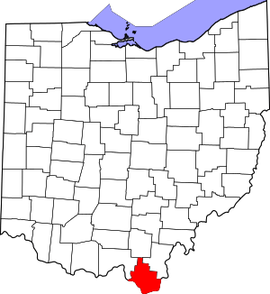 Map of Ohio highlighting Lawrence County | |
| Villages | ||
| Townships | ||
| CDP | ||
| Unincorporated communities | ||
| Footnotes | ‡This populated place also has portions in an adjacent county or counties | |
Huntington-Ashland-Ironton metropolitan area | ||
|---|---|---|
| Principal cities | 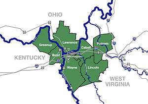 | |
| Municipalities with population over 5,000 | ||
| Municipalities with population 1,000–5,000 | ||
| Municipalities with population under 1,000 | ||
| West Virginia counties | ||
| Kentucky counties | ||
| Ohio counties | ||