Morgan County, West Virginia
Morgan County is a county located in the U.S. state of West Virginia. As of the 2010 census, the population was 17,541.[1] Its county seat is Berkeley Springs.[2] The county was formed in 1820 from parts of Hampshire and Berkeley Counties and named in honor of General Daniel Morgan, prominent soldier of the American Revolutionary War.[3]
Morgan County | |
|---|---|
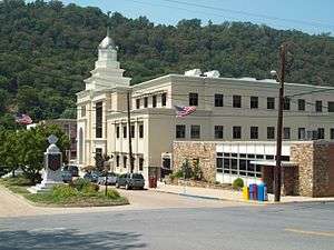 Morgan County Courthouse Complex, July 2011 | |
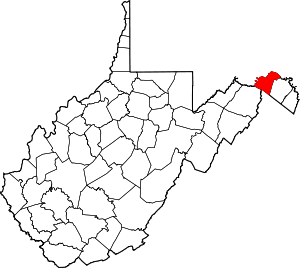 Location within the U.S. state of West Virginia | |
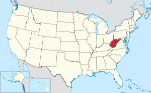 West Virginia's location within the U.S. | |
| Coordinates: 39°34′N 78°16′W | |
| Country | |
| State | |
| Founded | February 9, 1820 |
| Named for | Daniel Morgan |
| Seat | Berkeley Springs |
| Largest town | Berkeley Springs |
| Area | |
| • Total | 230 sq mi (600 km2) |
| • Land | 229 sq mi (590 km2) |
| • Water | 0.5 sq mi (1 km2) 0.2%% |
| Population (2010) | |
| • Total | 17,541 |
| • Estimate (2018) | 17,787 |
| • Density | 76/sq mi (29/km2) |
| Time zone | UTC−5 (Eastern) |
| • Summer (DST) | UTC−4 (EDT) |
| Congressional district | 2nd |
| Website | www |
Morgan County is the home of an important mine producing special sand for the glass industry.
History
Morgan County was created by an act of the Virginia General Assembly in February 1820 from parts of Berkeley and Hampshire counties. It was named in honor of General Daniel Morgan (1736–1802). He was born in Hunterdon County, New Jersey, and moved to Winchester, Virginia as a youth. He served as a wagoner in Braddock's Army during the campaign against the Native Americans in 1755. During the campaign, a British Lieutenant became angry with him and hit him with the flat of his sword. Morgan punched the Lieutenant, knocking him unconscious. Morgan was court-martialed for striking a British officer and was sentenced to 500 lashes. Morgan later joked that the drummer who counted out the lashes miscounted and he received only 499 lashes. For the rest of his life he claimed the British still owed him one.
Early European settlers
The first English settlers in present-day Morgan County arrived during the 1730s. Because most of these early pioneers were squatters, there is no record of their names. Historians claim that the first cabin in the county was built around 1745. As word of the county's warm springs spread eastward, Thomas Fairfax, 6th Lord Fairfax of Cameron decided that the county needed to be surveyed. In 1748, George Washington, then just 16 years old, was part of the survey party the surveyed the Eastern Panhandle region for Lord Fairfax. He later returned to Bath (Berkeley Springs) several times over the next several years with his half-brother, Lawrence, who was ill and hoped that the warm springs might improve his health. The springs, and their rumored medicinal benefits, attracted numerous Native Americans as well as Europeans to the area.
18th century
As mentioned previously, George Washington visited present-day Berkeley Springs several times with his half-brother, Lawrence. When he vacationed in the area in 1767, he noted how busy the town had become. Lord Fairfax had built a summer home there and a "private bath" making the area a popular destination for Virginia's social elite. As the town continued to grow, the Virginia General Assembly decided to formally recognize it. In October 1776, the town was officially named Bath, in honor of England's spa city called Bath. The town's main north–south street was named Washington and the main east–west street was named Fairfax. Also, seven acres (28,000 m²) were set aside for "suffering humanity." When West Virginia gained statehood, that area became West Virginia's first state park.
Bath's population increased during and immediately after the American Revolutionary War as wounded soldiers and others came to the area believing that the warm springs had medicinal qualities. Bath gained a reputation as a somewhat wild town where eating, drinking, dancing, and gambling on the daily horse races were the order of the day.
Bath later became known as Berkeley Springs, primarily because the town's post office took that name (combining Governor Norborne Berkeley's last name with the warm springs found there) to avoid confusion with another post office, located in southeastern Virginia, which was already called Bath. Because the mail was sent to and from Berkeley Springs, that name slowly took precedence.
19th century
Morgan County was one of fifty Virginia counties that were admitted to the Union as the state of West Virginia on June 20, 1863. Later that year, the counties were divided into civil townships, with the intention of encouraging local government. This proved impractical in the heavily rural state, and in 1872 the townships were converted into magisterial districts.[4] Morgan County was divided into six districts: Allen, Bath, Cacapon,[lower-roman 1] Rock Gap, Sleepy Creek, and Timber Ridge. Except for minor adjustments, the historic magisterial districts remained unchanged until the 1980s, when they were consolidated into three new districts: District 1, District 2, and District 3. A District 4 was created in the 1990s, but subsequently discontinued.[5]
20th century
On April 10, 1919, racial violence broke out when the Morgan County race riot was sparked by big business using African-American strikebreakers against local striking white workers.[6] On the same day of the riots one Hugh Ferguson, a Martinsburg African-American, was accused of criminally assaulting Mrs. Ernest Zimmerman at her home near Brosius, Morgan County (now known as Hancock, West Virginia). An angry mob of several hundred men formed around the jail hoping to lynch Ferguson. Sheriff C. R. Hovermale was forced to flee town with Ferguson.[7]
Geography
According to the U.S. Census Bureau, the county has a total area of 230 square miles (600 km2), of which 229 square miles (590 km2) is land and 0.5 square miles (1.3 km2) (0.2%) is water.[8]
Major highways


Adjacent counties
- Washington County, Maryland (north)
- Berkeley County (east)
- Frederick County, Virginia (southeast)
- Hampshire County (southwest)
- Allegany County, Maryland (northwest)
Rivers and streams
Demographics
| Historical population | |||
|---|---|---|---|
| Census | Pop. | %± | |
| 1820 | 2,500 | — | |
| 1830 | 2,694 | 7.8% | |
| 1840 | 4,253 | 57.9% | |
| 1850 | 3,557 | −16.4% | |
| 1860 | 3,732 | 4.9% | |
| 1870 | 4,315 | 15.6% | |
| 1880 | 5,777 | 33.9% | |
| 1890 | 6,744 | 16.7% | |
| 1900 | 7,294 | 8.2% | |
| 1910 | 7,848 | 7.6% | |
| 1920 | 8,357 | 6.5% | |
| 1930 | 8,406 | 0.6% | |
| 1940 | 8,743 | 4.0% | |
| 1950 | 8,276 | −5.3% | |
| 1960 | 8,376 | 1.2% | |
| 1970 | 8,547 | 2.0% | |
| 1980 | 10,711 | 25.3% | |
| 1990 | 12,128 | 13.2% | |
| 2000 | 14,943 | 23.2% | |
| 2010 | 17,541 | 17.4% | |
| Est. 2018 | 17,787 | [9] | 1.4% |
| U.S. Decennial Census[10] 1790–1960[11] 1900–1990[12] 1990–2000[13] 2010-2018[1] | |||
2000 census
As of the census[14] of 2000, there were 14,943 people, 6,145 households, and 4,344 families living in the county. The population density was 65 people per square mile (25/km²). There were 8,076 housing units at an average density of 35 per square mile (14/km²). The racial makeup of the county was 98.30% White, 0.60% Black or African American, 0.17% Native American, 0.12% Asian, 0.01% Pacific Islander, 0.23% from other races, and 0.57% from two or more races. 0.83% of the population were Hispanic or Latino of any race.
There were 6,145 households out of which 28.70% had children under the age of 18 living with them, 57.90% were married couples living together, 8.20% had a female householder with no husband present, and 29.30% were non-families. 24.50% of all households were made up of individuals and 10.20% had someone living alone who was 65 years of age or older. The average household size was 2.40 and the average family size was 2.84.
The age distribution is 22.40% under the age of 18, 6.80% from 18 to 24, 27.30% from 25 to 44, 26.90% from 45 to 64, and 16.60% who were 65 years of age or older. The median age was 41 years. For every 100 females there were 96.60 males. For every 100 females age 18 and over, there were 95.00 males.
The median income for a household in the county was $35,016, and the median income for a family was $40,690. Males had a median income of $29,816 versus $22,307 for females. The per capita income for the county was $18,109. About 8.00% of families and 10.40% of the population were below the poverty line, including 11.60% of those under age 18 and 8.80% of those age 65 or over.
2010 census
As of the 2010 United States Census, there were 17,541 people, 7,303 households, and 5,015 families living in the county.[15] The population density was 76.6 inhabitants per square mile (29.6/km2). There were 9,753 housing units at an average density of 42.6 per square mile (16.4/km2).[16] The racial makeup of the county was 97.3% white, 0.6% black or African American, 0.3% Asian, 0.3% Native American, 0.2% from other races, and 1.3% from two or more races. Those of Hispanic or Latino origin made up 1.0% of the population.[15] In terms of ancestry, 27.0% were German, 13.2% were Irish, 11.5% were American, and 10.6% were English.[17]
Of the 7,303 households, 27.8% had children under the age of 18 living with them, 54.1% were married couples living together, 8.9% had a female householder with no husband present, 31.3% were non-families, and 25.7% of all households were made up of individuals. The average household size was 2.39 and the average family size was 2.84. The median age was 45.0 years.[15]
The median income for a household in the county was $37,281 and the median income for a family was $49,974. Males had a median income of $39,372 versus $27,949 for females. The per capita income for the county was $20,732. About 11.9% of families and 15.8% of the population were below the poverty line, including 22.0% of those under age 18 and 10.6% of those age 65 or over.[18]
Government and public safety
County government
Morgan County has an elected three member County Commission.
Morgan County Sheriff
The Sheriff's Office operates the county jail, provides court protection, provides county building and facility security, and provides patrol and detective services for the county.
Politics
Morgan County has historically been a stronghold for the Republican Party. Every Republican presidential nominee has won Morgan County since 1864, the first presidential election following West Virginia's statehood. The last Democratic presidential nominee to win Morgan County was Lewis Cass in 1848; the county was won by the Whig Party, the Know-Nothing Party and John Bell’s Constitutional Union Party in its last three elections as part of Virginia.
| Year | Republican | Democratic | Third parties |
|---|---|---|---|
| 2016 | 74.1% 5,732 | 20.3% 1,573 | 5.6% 432 |
| 2012 | 63.8% 4,513 | 33.4% 2,363 | 2.8% 195 |
| 2008 | 60.9% 4,428 | 37.4% 2,721 | 1.8% 127 |
| 2004 | 65.9% 4,511 | 33.2% 2,272 | 0.9% 64 |
| 2000 | 63.1% 3,639 | 33.6% 1,939 | 3.4% 194 |
| 1996 | 51.2% 2,599 | 38.0% 1,929 | 10.9% 552 |
| 1992 | 48.4% 2,585 | 34.7% 1,854 | 16.9% 905 |
| 1988 | 65.8% 3,002 | 33.9% 1,545 | 0.4% 17 |
| 1984 | 70.3% 3,469 | 29.5% 1,457 | 0.1% 6 |
| 1980 | 61.2% 2,833 | 34.5% 1,594 | 4.3% 200 |
| 1976 | 55.1% 2,369 | 44.9% 1,929 | |
| 1972 | 72.9% 3,014 | 27.1% 1,118 | |
| 1968 | 60.3% 2,244 | 27.3% 1,015 | 12.4% 461 |
| 1964 | 50.6% 1,866 | 49.4% 1,820 | |
| 1960 | 66.8% 2,752 | 33.2% 1,369 | |
| 1956 | 72.7% 2,946 | 27.3% 1,104 | |
| 1952 | 70.8% 2,699 | 29.2% 1,114 | |
| 1948 | 66.1% 2,159 | 33.8% 1,104 | 0.1% 4 |
| 1944 | 72.0% 2,303 | 28.0% 895 | |
| 1940 | 66.6% 2,563 | 33.4% 1,286 | |
| 1936 | 61.1% 2,555 | 38.7% 1,620 | 0.2% 9 |
| 1932 | 59.8% 2,082 | 39.0% 1,358 | 1.2% 43 |
| 1928 | 76.8% 2,539 | 22.9% 758 | 0.3% 11 |
| 1924 | 63.1% 1,883 | 30.8% 919 | 6.1% 182 |
| 1920 | 71.5% 1,817 | 28.0% 712 | 0.5% 13 |
| 1916 | 63.5% 1,208 | 35.0% 666 | 1.6% 30 |
| 1912 | 34.9% 612 | 31.3% 549 | 33.8% 593 |
Communities

Towns
- Berkeley Springs (county seat)
- Paw Paw
Magisterial districts
Current
- District 1
- District 2
- District 3
Historic
- Allen
- Bath
- Cacapon
- Rock Gap
- Sleepy Creek
- Timber Ridge
- District 4
Census-designated places
Unincorporated communities
- Berryville
- Burnt Factory
- Campbells
- Cherry Run
- Doe Gully
- Duckwall
- Green Ridge
- Greenwood
- Hancock (formerly Brosius)
- Hansrote
- Holton
- Jerome
- Jimtown
- Johnsons Mill
- Largent
- Lineburg
- Magnolia
- Mount Trimble
- New Hope
- North Berkeley
- Oakland
- Omps
- Orleans Cross Roads
- Redrock Crossing
- Ridersville
- Ridge
- Rock Gap
- Sir Johns Run
- Sleepy Creek
- Smith Crossroads
- Spohrs Crossroads
- Stotlers Crossroads
- Unger
- Woodmont
- Woodrow
Historic Places
The following are listed on the National Register of Historic Places:
| Site | Year Built | Address | Community | Listed |
|---|---|---|---|---|
| Ambrose Chapel | mid-19th century | Winchester Grade Road (CR 13) | Stotlers Crossroads | 1998 |
| Berkeley Springs State Park | mid-18th century | South Washington & Fairfax Streets | Berkeley Springs | 1976 |
| Berkeley Springs Train Depot | 1900–1924 | 504 North Washington Street (US 522) | Berkeley Springs | 2001 |
| Chesapeake and Ohio Canal National Historical Park | early 19th century | Chesapeake & Ohio Canal | Paw Paw | 1966 |
| Clarence Hovermale House (Allen Mendenhall House) | late 19th century | 167 Wilkes Street | Berkeley Springs | 2003 |
| John Herbert Quick House (Coolfont Manor House) | 1913 | Cold Run Valley Road | Berkeley Springs | 1984 |
| Judge John W. Wright Cottage | 1872 | 305 South Green Street | Berkeley Springs | 1986 |
| Morgan County Courthouse | 1923 | 202 Fairfax Street | Berkeley Springs | 2005 |
| Samuel Taylor Suit Cottage (Berkeley Castle) | 1885 | WV 9 | Berkeley Springs | 1980 |
| Sloat-Horn-Rossell House (The Manor) | late 19th century | 415 Fairfax Street | Berkeley Springs | 1984 |
| T. H. B. Dawson House | 1880 | 300 South Green Street | Berkeley Springs | 1983 |
| Western Maryland Railroad Right-of-Way, Milepost 126 to Milepost 160 | 20th century | Milepost 126 to Milepost 160 | Jerome | 1981 |
See also
- Berkeley Springs State Park
- Cacapon Resort State Park
- List of routes in Morgan County, West Virginia
- USS Morgan County (LST-1048)
- Morgan County Observatory with 16 inch quartz glass mirror telescope originally at United States Naval Academy
- National Register of Historic Places listings in Morgan County, West Virginia
Footnotes
- Also called "Great Cacapon" before 1900.
References
- "State & County QuickFacts". United States Census Bureau. Archived from the original on June 30, 2011. Retrieved January 10, 2014.
- "Find a County". National Association of Counties. Retrieved June 7, 2011.
- "Archived copy". Archived from the original on May 29, 2013. Retrieved January 29, 2013.CS1 maint: archived copy as title (link)
- Otis K. Rice & Stephen W. Brown, West Virginia: A History, 2nd ed., University Press of Kentucky, Lexington (1993), p. 240.
- United States Census Bureau, U.S. Decennial Census, Tables of Minor Civil Divisions in West Virginia, 1870–2010.
- Marcelle 2016.
- The Wheeling Intelligencer 1919, p. 1.
- "2010 Census Gazetteer Files". United States Census Bureau. August 22, 2012. Retrieved July 30, 2015.
- "Population and Housing Unit Estimates". Retrieved May 21, 2019.
- "U.S. Decennial Census". United States Census Bureau. Retrieved January 10, 2014.
- "Historical Census Browser". University of Virginia Library. Retrieved January 10, 2014.
- "Population of Counties by Decennial Census: 1900 to 1990". United States Census Bureau. Retrieved January 10, 2014.
- "Census 2000 PHC-T-4. Ranking Tables for Counties: 1990 and 2000" (PDF). United States Census Bureau. Retrieved January 10, 2014.
- "U.S. Census website". United States Census Bureau. Retrieved 2011-05-14.
- "DP-1 Profile of General Population and Housing Characteristics: 2010 Demographic Profile Data". United States Census Bureau. Archived from the original on February 13, 2020. Retrieved April 3, 2016.
- "Population, Housing Units, Area, and Density: 2010 - County". United States Census Bureau. Archived from the original on February 13, 2020. Retrieved April 3, 2016.
- "DP02 SELECTED SOCIAL CHARACTERISTICS IN THE UNITED STATES – 2006-2010 American Community Survey 5-Year Estimates". United States Census Bureau. Archived from the original on February 13, 2020. Retrieved April 3, 2016.
- "DP03 SELECTED ECONOMIC CHARACTERISTICS – 2006-2010 American Community Survey 5-Year Estimates". United States Census Bureau. Archived from the original on February 13, 2020. Retrieved April 3, 2016.
- Leip, David. "Dave Leip's Atlas of U.S. Presidential Elections". Uselectionatlas.org. Retrieved December 23, 2017.
Bibliography
- Marcelle, Dale (2016). Pitchforks and Negro Babies: America's Shocking History of Hate. AuthorHouse. ISBN 9781524625764.CS1 maint: ref=harv (link) - Total pages: 328
- The Wheeling Intelligencer (April 10, 1919). "Negro Nearly Lynched After Brutal Attack". The Intelligencer and Wheeling News Register. Wheeling, West Virginia. OCLC 13502337. Retrieved July 18, 2019.CS1 maint: ref=harv (link)
Further reading
- Fowler, Virginia G. 2002. Brigadier General Daniel Morgan, Washington, D.C.: National Park Service.
- Morgan County Historical and Genealogical Society. 1981. Morgan County, West Virginia and Its People. Berkeley Springs: Morgan County Historical and Genealogical Society.
- Cartmell, Thomas Kemp. 1909. Shenandoah Valley Pioneers and Their Descendants: A History of Frederick County, Virginia. Winchester, VA: The Eddy Corporation.
- Newbraugh, Frederick T. 1967. Warm Springs Echoes: About Berkeley Springs and Morgan County. Part 1: To 1860. Hagerstown, MD: Automated Systems Corporation.
- Dr. Robert Jay Dilger, Director, Institute for Public Affairs and Professor of Political Science, West Virginia University.
External links
| Wikimedia Commons has media related to Morgan County, West Virginia. |
- MorganCountyUSA
- Berkeley Springs-Morgan County Chamber of Commerce
- Morgan Arts Council
- Morgan County Community Organizations
- County Public Library
- Morgan County Schools
- The Morgan Messenger
- Morgan County Solid Waste Authority
- Morgan County Observatory
- WVU Extension Service - Morgan County
Places adjacent to Morgan County, West Virginia | ||||||||||
|---|---|---|---|---|---|---|---|---|---|---|
| ||||||||||
Municipalities and communities of Morgan County, West Virginia, United States | ||
|---|---|---|
| Towns | Map of West Virginia highlighting Morgan County | |
| CDP | ||
| Unincorporated communities |
| |

| Authority control |
|
|---|