Cape Lloyd
Cape Lloyd (61°7′S 54°1′W) is a cape which forms the north end of Clarence Island in the South Shetland Islands of Antarctica, on the north side of the entrance to Kutela Cove. The name "Lloyd's Promontory" appears on charts of the 1821–25 period, but in more recent years the feature has become internationally known as Cape Lloyd.[2]
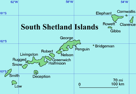
Location of Clarence Island in the South Shetland Islands.
.jpg) | |
 Cape Lloyd [1] Antarctica | |

| |
| Location | Cape Lloyd Clarence Island South Shetland Islands Antarctica |
|---|---|
| Coordinates | 61°07′52″S 54°00′34″W |
| Year first constructed | n/a |
| Foundation | concrete base |
| Construction | fberglass tower[1] |
| Tower shape | cylindrical tower with lantern |
| Markings / pattern | white tower with horizontal red bands[1] |
| Tower height | 3 metres (9.8 ft)[1] |
| Focal height | 113 metres (371 ft)[1] |
| Light source | solar power |
| Range | 5 nautical miles (9.3 km; 5.8 mi)[1] |
| Characteristic | Fl W 10s.[1] |
| Admiralty number | G1388.2[1] |
| NGA number | 2720.5[1] |
See also
References
- List of Lights, Pub. 111: The West Coasts of North and South America (Excluding Continental U.S.A. and Hawaii), Australia, Tasmania, New Zealand, and the Islands of the North and South Pacific Oceans (PDF). List of Lights. United States National Geospatial-Intelligence Agency. 2017.
- "Cape Lloyd". Geographic Names Information System. United States Geological Survey. Retrieved 2013-06-27.
![]()
Clarence Island seen from northeast with (left to right) Cape Bowles, Istros Bay, Sugarloaf Island, Smith Cove, Kakrina Point, Kutela Cove and Cape Lloyd surmounted by Jubilee Peak.
This article is issued from Wikipedia. The text is licensed under Creative Commons - Attribution - Sharealike. Additional terms may apply for the media files.