Dêmqog, Ngari Prefecture
Dêmqog (Chinese: 典角村 ; Tibetan: ཌེམ་ཆོག་), spelt as Demchok in English,[1] is a small Tibetan village in the Chinese-controlled portion of the disputed Demchok sector between China and India and is administered as part of the Ngari Prefecture, Tibet Autonomous Region by China.
Dêmqog ཌེམ་ཆོག་ Demchok | |
|---|---|
Village | |
 Dêmqog ཌེམ་ཆོག་  Dêmqog ཌེམ་ཆོག་ 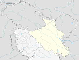 Dêmqog ཌེམ་ཆོག་  Dêmqog ཌེམ་ཆོག་ | |
| Coordinates: 32°41′40″N 79°27′45″E | |
| Country | China |
| Region | Tibet |
| Prefecture | Ngari Prefecture |
| County | Gar County |
| Township | Tashigang (བཀྲ་ཤིས་སྒང་ 扎西岗乡) |
| Elevation | 4,240 m (13,920 ft) |
Description
 |
Dêmqog lies a kilometer southeast from the Indian-controlled Demchok village, which is to the northwest of the Demchok River (or Charding Nullah). The river forms the Line of Actual Control between China and India.
Prior to the 1962 Sino-Indian War, India had extended its claim to about 3 miles southeast of the Demchok River. Dêmqog would have been included within its administration. The combined Chinese-Indian village is said to have had a population of about 150.[2]
See also
- List of towns and villages in Tibet
References
- Lange, Decoding Mid-19th Century Maps of the Border Area (2017), p. 353: '... the village of Demchok marked the border between Tibet and Ladakh for a long time. Abdul Wahid Radhu, a former representative of the Lopchak caravan,[14] described Demchok in his travel account as “the first location on the Tibetan side of the border”.'
- Luv Puri, Ladakhis await re-opening of historic Tibet route, The Hindu, 2 August 2005.
Bibliography
- Lange, Diana (2017), "Decoding Mid-19th Century Maps of the Border Area between Western Tibet, Ladakh, and Spiti", Revue d'Etudes Tibétaines,The Spiti Valley Recovering the Past and Exploring the Present
| County-level divisions | 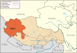 | |
|---|---|---|
| Towns and villages | ||
| Geography |
| |
| Landmarks | ||