James Peak Wilderness
The James Peak Wilderness is a U.S. Wilderness Area in north central Colorado in the Arapaho and Roosevelt national forests. The wilderness area borders Indian Peaks Wilderness to the north and the James Peak Protection Area to the west.[1]
| James Peak Wilderness | |
|---|---|
IUCN category Ib (wilderness area) | |
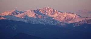 James Peak in the James Peak Wilderness | |
 | |
| Location | Gilpin / Clear Creek counties, Colorado, USA |
| Nearest city | Black Hawk, CO |
| Coordinates | 39°51′08″N 105°41′24″W |
| Area | 17,015 acres (68.86 km2) |
| Established | 2002 |
| Governing body | U.S. Forest Service |
Geography
The wilderness area encompasses 17,015 acres (69 km2) immediately east of the Continental Divide in Gilpin County and Clear Creek County. The wilderness is named after its second tallest mountain, 13,294-foot (4,052 m) James Peak. Parry Peak is the highest peak in the James Peak Wilderness, at 13,391 feet (4,082 m).[2]
History
The wilderness was established by H.R.1576 in the 107th Congress (2001). James Peak was named after Edwin James, pioneer and botanist. Originally Pikes Peak was named James Peak prior to Pike's exploration journey. After the renaming to Pikes Peak, the current James Peak was named.[3]
References
- "James Peak Wilderness". U.S. Forest Service. Retrieved August 11, 2012.
- "James Peak Wilderness". Wilderness.net. Retrieved August 11, 2012.
- "James Peak Wilderness Area". Colorado Wilderness. Retrieved August 11, 2012.