Gold Hill, Colorado
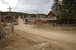
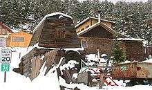
Gold Hill is a census-designated place (CDP) in Boulder County, Colorado, United States. The population was 230 at the 2010 census.[2] This settlement is located to the northwest of Boulder, perched on a mountainside above Left Hand Canyon at an elevation of 8,300 feet. Originally a mining camp, it was the site of the first major discovery of gold during the 1859 Colorado Gold Rush and remained an important mining camp throughout the late 19th century, with a population approaching 1500 at its height, before falling into decline. It has been revived somewhat in recent years as a quiet isolated haven, with no paved streets, but easily accessed by dirt roads. The town contains numerous historic wooden structures, some restored in recent years, as well as decaying ruins from its mining heyday. It has a small museum and two-room schoolhouse, the Gold Hill School, which since 1873 has been the oldest continuously operating public school in Colorado. Other businesses include a General Store and a restored inn listed on the National Register of Historic Places. The town is laid out on a small grid of dirt streets.
Gold Hill | |
|---|---|
 | |
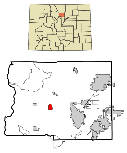 Location in Boulder County and the state of Colorado | |
 Gold Hill Location in Colorado  Gold Hill Gold Hill (the United States) | |
| Coordinates: 40°3′50″N 105°24′43″W | |
| Country | |
| State | |
| County | Boulder |
| Area | |
| • Total | 2 sq mi (5.2 km2) |
| • Land | 2 sq mi (5.2 km2) |
| • Water | 0 sq mi (0 km2) |
| Elevation | 8,300 ft (2,530 m) |
| Population (2010) | |
| • Total | 230 |
| • Density | 105/sq mi (40.4/km2) |
| Time zone | UTC-7 (MST) |
| • Summer (DST) | UTC-6 (MDT) |
| ZIP code | 80302 (Boulder) |
| FIPS code | 08-30945 |
| GNIS feature ID | 0178502 |
Gold Hill Historic District | |
| Location | Roughly bounded by North St., Pine St., Boulder St., Gold Run St., and College St. |
| Built | 1872 |
| Architectural style | Late 19th And 20th Century Revivals |
| MPS | Metal Mining and Tourist Era Resources of Boulder County MPS |
| NRHP reference No. | 89000979[1] |
| CSRHP No. | 5BL.769 |
| Added to NRHP | August 3, 1989 |
Gold Hill is accessible from nearby Left Hand Canyon Road via Lick Skillet Road. Easier approaches to Gold Hill include Sunshine Canyon Road from 4th and Mapleton in Boulder, Gold Run Road from Salina (on Four Mile Canyon Road), and Gold Hill Road from the Peak to Peak Highway (State Highway 72) south of Ward. All of these roads are susceptible to heavy snows during the winter, which at times render Gold Hill inaccessible to vehicles not equipped with chains or four wheel drive.
Gold Hill is sometimes labeled a ghost town, which is an inaccurate designation. Gold Hill is part of unincorporated Boulder County, and while it does not have a municipal government, it does have an active town meeting with elected officials.
History
The community is located above Gold Run, the first lode discovery of gold in Colorado (at that time the area was part of the Nebraska Territory) on January 15, 1859. The discovery occurred nearly simultaneous with prospecting in Gregory Gulch and Clear Creek, but these latter discoveries were not exploited until later that Spring. On March 7, 1859, the Gold Run discovery became the first mining district in region (named either the Mountain District No. 1, Mining District No. 1 of the Nebraska Territory, or the Nebraska Gold Hill Mining District, according to various historical sources). Word quickly spread among miners in the region, prompting a flood of new arrivals and the establishment of Gold Hill as the first permanent mining camp in present-day Colorado. By autumn, a quartz stamp mill was erected at the base of the hill, the first such piece of equipment in the region, one that had been transported by ox cart westward over the Great Plains. The first productive vein was the Scott, followed quickly the Horsfal, Alamakee, and Cold Spring. Nearby placers were also worked for the gold in stream beds.
By 1861, the year of the organization of the Colorado Territory, the surface deposits of gold in the vicinity of the town were largely played out, resulting in a temporary exodus of prospectors and a population decrease. The town was somewhat revived later that year by the construction of the Hill smelter at nearby Black Hawk, allowing the treatment of lower-grade ores.
The discovery of tellurium in the area in 1872 prompted a second boom, bringing the population to nearly 1000 once again. At its height, the town had a newspaper and number of hotels, including the Mines Hotel, built in 1872 and recently restored as summer tourist destination. The Mines was immortalized in verse by poet Eugene Field, who stayed at the hotel while working as a newspaper man in Denver. The town population dwindled in the early 20th century as the mining tapered off. The town has experienced two major fires in its history, but it nevertheless retains many of its historic wooden structures.
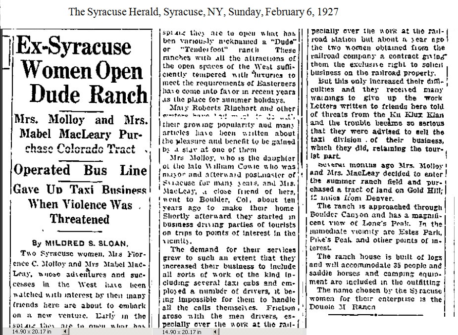
Despite a dwindling permanent population, Gold Hill continued to remain attractive to tourists. Around 1926 Florence Molloy and Mabel MacLeay, previously the owners of the Molloy-MacLeay taxicab company in Boulder, CO, opened the Double M Dude Ranch (or M&M ranch, then Trojan Ranch, and now the Colorado Mountain Ranch) in Gold Hill, CO.[3] The Syracuse Herald, described the Double M as offering, “all the attractions of the open spaces of the West sufficiently tempered with luxuries to meet the requirement of Easterners.”[4] The Double MM operated until World War II when it was sold in 1941 and subsequently became the Trojan Ranch and then later the Colorado Mountain Ranch (currently in operation).[5]
In 1921, The Holiday House Association of Chicago, started by Jean Sherwood, purchased the hotel at Gold Hill, now the Gold Hill Inn, to create a summer camp destination for self-supporting single women from Chicago. These vacationing women were referred to as "Bluebirds." The Bluebird Lodge addition to the hotel was completed around 1926.[6]
In September 2010, the Four Mile Canyon wildfire destroyed approximately 170 homes in and around Gold Hill.[7]
Geography
According to the United States Census Bureau, the CDP has a total area of 2.0 square miles (5.2 km2), all of it land.
Demographics
As of the census[8] of 2000, there were 210 people, 90 households, and 47 families residing in the CDP. The population density was 104.7 people per square mile (40.3/km²). There were 114 housing units at an average density of 56.8 per square mile (21.9/km²). The racial makeup of the CDP was 89.05% White, 0.48% African American, 3.33% Native American, 1.90% Asian, 4.29% from other races, and 0.95% from two or more races. Hispanic or Latino of any race were 7.62% of the population.
There were 90 households out of which 33.3% had children under the age of 18 living with them, 46.7% were married couples living together, 2.2% had a female householder with no husband present, and 46.7% were non-families. 35.6% of all households were made up of individuals and 1.1% had someone living alone who was 65 years of age or older. The average household size was 2.33 and the average family size was 3.00.
In the CDP, the population was spread out with 22.9% under the age of 18, 4.8% from 18 to 24, 37.1% from 25 to 44, 32.4% from 45 to 64, and 2.9% who were 65 years of age or older. The median age was 40 years. For every 100 females, there were 114.3 males. For every 100 females age 18 and over, there were 116.0 males.
The median income for a household in the CDP was $48,750, and the median income for a family was $76,850. Males had a median income of $48,929 versus $12,105 for females. The per capita income for the CDP was $24,675. None of the population or families were below the poverty line.
See also
- Outline of Colorado
- Index of Colorado-related articles
- Boulder, CO Metropolitan Statistical Area
- Switzerland Trail
References
- "National Register Information System". National Register of Historic Places. National Park Service. March 13, 2009.
- Colorado Trend Report 2: State and Complete Places (Sub-state 2010 Census Data). Missouri Census Data Center. Accessed 2011-02-25.
- "Revealing Our Routes: women of Boulder County | Carnegie Library for Local History". localhistory.boulderlibrary.org. Retrieved 2019-11-24.
- Sloan, Mildred (6 February 1927). "Ex-Syracuse Women Open Dude Ranch". The Syracuse Herald. Retrieved 23 November 2019.
- "Longtime resident reflects on Boulder living, wrangling". Boulder Daily Camera. 2013-01-04. Retrieved 2019-11-24.
- "Bluebird Cottage--Early Pastoral Haven for the Working Girl : History: A women's rights activist named Jean Wirt Sherwood came to a meadow in Boulder in 1904 and immediately saw it as a vacation retreat for the weary". Los Angeles Times. 1990-07-26. Retrieved 2019-11-24.
- http://www.kdvr.com/news/kdvr-fourmile-fire-community-meeting-txt,0,7516523.story
- "U.S. Census website". United States Census Bureau. Retrieved 2008-01-31.
Further reading
- Brown, Robert L. Jeep Trails to Colorado Ghost Towns. Caldwell: Caxton, 1963.
| Wikimedia Commons has media related to Gold Hill, Colorado. |
Municipalities and communities of Boulder County, Colorado, United States | ||
|---|---|---|
| Cities | 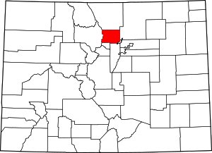 Map of Colorado highlighting Boulder County | |
| Towns | ||
| CDPs | ||
| Unincorporated communities | ||
| Ghost town | ||
| Footnotes | ‡This populated place also has portions in an adjacent county or counties | |
| Authority control |
|
|---|