Big Horn County, Montana
Big Horn County is a county in the U.S. state of Montana. As of the 2010 United States Census, the population was 12,865.[1] The county seat is Hardin.[2] The county, like the river and mountain range, were named for the bighorn sheep in the Rocky Mountains.[3] The county was founded in 1913.[4] It is located on the south line of the state.
Big Horn County | |
|---|---|
_001.jpg) | |
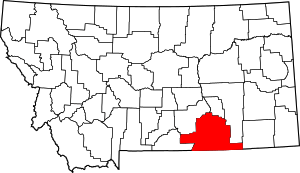 Location within the U.S. state of Montana | |
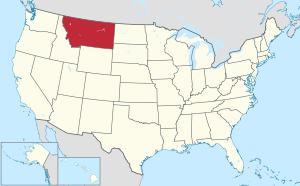 Montana's location within the U.S. | |
| Coordinates: 45°26′N 107°29′W | |
| Country | |
| State | |
| Founded | January 13, 1913 |
| Named for | Bighorn sheep |
| Seat | Hardin |
| Largest city | Hardin |
| Area | |
| • Total | 5,015 sq mi (12,990 km2) |
| • Land | 4,995 sq mi (12,940 km2) |
| • Water | 19 sq mi (50 km2) 0.4% |
| Population (2010) | |
| • Total | 12,865 |
| • Estimate (2018) | 13,338 |
| • Density | 2.6/sq mi (0.99/km2) |
| Time zone | UTC−7 (Mountain) |
| • Summer (DST) | UTC−6 (MDT) |
| Congressional district | At-large |
| Website | www |
| |
Most of the area is part of the Crow Indian Reservation. Reservation poverty affects the county, which is the second poorest county in the state.
Law and government
The county has several jurisdictions, each with its own regulations and law enforcement agencies. The Crow and Northern Cheyenne Indian Nations are administered by the tribes. Little Bighorn Battlefield and the Big Horn Canyon National Recreation Area are regulated by the National Park Service. The remainder of the county falls under the State of Montana.
Geography
According to the US Census Bureau, the county has a total area of 5,015 square miles (12,990 km2), of which 4,995 square miles (12,940 km2) is land and 19 square miles (49 km2) (0.4%) is water.[5] It is the fifth-largest county in Montana by land area. Most of the county's land area is Indian reservations: The Crow Indian Reservation covers 64.2 percent of its area, while the Northern Cheyenne Indian Reservation covers another 6.37 percent.
The county is home to the Big Horn, Pryor and Wolf mountain ranges.
Major highways


- Montana Highway 313
- Montana Highway 314

Adjacent counties
- Carbon - west
- Yellowstone - northwest
- Treasure - north
- Rosebud - northeast
- Powder River - east
- Sheridan County, Wyoming - south
- Big Horn County, Wyoming - southwest
National protected areas
Climate
According to the Köppen Climate Classification system, Big Horn County has a semi-arid climate, abbreviated "BSk" on climate maps.[6]
Politics
Big Horn County is generally Democratic, owing largely to its majority Native American population. It is distinguished from most other counties in rural Montana, which often lean heavily Republican.
| Year | Republican | Democratic | Third parties |
|---|---|---|---|
| 2016 | 43.7% 1,853 | 49.4% 2,094 | 6.8% 290 |
| 2012 | 36.0% 1,667 | 62.3% 2,882 | 1.7% 77 |
| 2008 | 31.2% 1,628 | 67.4% 3,516 | 1.4% 75 |
| 2004 | 47.0% 2,028 | 51.4% 2,215 | 1.6% 68 |
| 2000 | 39.7% 1,651 | 56.4% 2,345 | 4.0% 165 |
| 1996 | 31.5% 1,336 | 57.9% 2,453 | 10.6% 450 |
| 1992 | 31.3% 1,377 | 49.0% 2,154 | 19.6% 863 |
| 1988 | 43.0% 1,711 | 56.1% 2,233 | 1.0% 40 |
| 1984 | 46.8% 2,390 | 52.5% 2,681 | 0.8% 39 |
| 1980 | 46.3% 1,730 | 44.0% 1,644 | 9.7% 361 |
| 1976 | 44.5% 1,615 | 54.1% 1,962 | 1.5% 53 |
| 1972 | 56.2% 2,148 | 40.6% 1,552 | 3.2% 124 |
| 1968 | 53.9% 1,789 | 39.7% 1,319 | 6.4% 213 |
| 1964 | 37.1% 1,481 | 62.8% 2,509 | 0.1% 3 |
| 1960 | 53.5% 1,724 | 46.4% 1,497 | 0.1% 3 |
| 1956 | 56.4% 1,739 | 43.6% 1,342 | 0.0% 0 |
| 1952 | 65.9% 2,165 | 33.9% 1,114 | 0.2% 6 |
| 1948 | 49.4% 1,334 | 49.2% 1,328 | 1.5% 40 |
| 1944 | 51.7% 1,394 | 47.8% 1,289 | 0.5% 12 |
| 1940 | 45.4% 1,616 | 54.1% 1,926 | 0.5% 18 |
| 1936 | 34.1% 1,087 | 63.9% 2,037 | 2.0% 62 |
| 1932 | 36.4% 957 | 62.3% 1,637 | 1.3% 34 |
| 1928 | 55.5% 1,274 | 44.3% 1,017 | 0.3% 6 |
| 1924 | 57.7% 1,082 | 17.5% 327 | 24.8% 465 |
| 1920 | 66.2% 1,062 | 29.6% 475 | 4.2% 68 |
| 1916 | 39.6% 497 | 59.0% 740 | 1.4% 17 |
Demographics
| Historical population | |||
|---|---|---|---|
| Census | Pop. | %± | |
| 1920 | 7,015 | — | |
| 1930 | 8,543 | 21.8% | |
| 1940 | 10,419 | 22.0% | |
| 1950 | 9,824 | −5.7% | |
| 1960 | 10,007 | 1.9% | |
| 1970 | 10,057 | 0.5% | |
| 1980 | 11,096 | 10.3% | |
| 1990 | 11,337 | 2.2% | |
| 2000 | 12,671 | 11.8% | |
| 2010 | 12,865 | 1.5% | |
| Est. 2018 | 13,338 | [8] | 3.7% |
| US Decennial Census[9] 1790-1960[10] 1900-1990[11] 1990-2000[12] 2010-2018[1] | |||
2000 census
As of the 2000 United States Census,[13] there were 12,671 people, 3,924 households, and 3,033 families living in the county. The population density was 2 people per square mile (1/km²). There were 4,655 housing units at an average density of <1/km² (1/sq mi). The racial makeup of the county was 36.60% White, 0.04% Black or African American, 59.66% Native American, 0.22% Asian, 0.01% Pacific Islander, 0.68% from other races, and 2.79% from two or more races. 3.67% of the population were Hispanic or Latino of any race. 13.9% were of German ancestry. 67.1% spoke English, 27.9% Crow, 2.5% Cheyenne and 1.3% Spanish as their first language.
There were 3,924 households out of which 42.40% had children under the age of 18 living with them, 54.00% were married couples living together, 17.60% had a female householder with no husband present, and 22.70% were non-families. 19.30% of all households were made up of individuals and 6.70% had someone living alone who was 65 years of age or older. The average household size was 3.17 and the average family size was 3.66.
The county population contained 35.80% under the age of 18, 8.60% from 18 to 24, 26.50% from 25 to 44, 20.50% from 45 to 64, and 8.60% who were 65 years of age or older. The median age was 30 years. For every 100 females there were 97.30 males. For every 100 females age 18 and over, there were 91.00 males.
The median income for a household in the county was $27,684, and the median income for a family was $31,095. Males had a median income of $23,814 versus $18,884 for females. The per capita income for the county was $10,792. About 23.70% of families and 29.20% of the population were below the poverty line, including 37.00% of those under age 18 and 20.10% of those age 65 or over.
2010 census
As of the 2010 United States Census, there were 12,865 people, 4,004 households, and 2,970 families living in the county.[14] The population density was 2.6 inhabitants per square mile (1.0/km2). There were 4,695 housing units at an average density of 0.9 per square mile (0.35/km2).[15] The racial makeup of the county was 64.3% American Indian, 31.4% white, 0.5% Asian, 0.2% black or African American, 1.0% from other races, and 2.6% from two or more races. Those of Hispanic or Latino origin made up 4.0% of the population.[14] In terms of ancestry, 12.1% were American, and 10.3% were German.[16]
Of the 4,004 households, 45.6% had children under the age of 18 living with them, 48.8% were married couples living together, 17.3% had a female householder with no husband present, 25.8% were non-families, and 23.0% of all households were made up of individuals. The average household size was 3.18 and the average family size was 3.77. The median age was 30.5 years.[14]
The median income for a household in the county was $36,550 and the median income for a family was $41,985. Males had a median income of $32,216 versus $27,917 for females. The per capita income for the county was $15,066. About 20.7% of families and 23.5% of the population were below the poverty line, including 32.4% of those under age 18 and 15.4% of those age 65 or over.[17]
Economy
Coal mining and agriculture play major roles in Big Horn County's economy. Farms and ranches in the county produce mainly beef cattle, sugar beets, alfalfa, and small grains.[18]
See also
- List of lakes in Big Horn County, Montana
- List of mountains in Big Horn County, Montana
- National Register of Historic Places listings in Big Horn County, Montana
References
- "State & County QuickFacts". US Census Bureau. Retrieved September 14, 2013.
- "Find a County". National Association of Counties. Archived from the original on May 31, 2011. Retrieved June 7, 2011.
- Merrill, Andrea; Judy Jacobson (1997). Montana almanac. Helena MT: Falcon Publishing. p. 7. ISBN 1-56044-493-2.
- "About Hardin & Big Horn County". Big Horn County Historical Museum. Archived from the original on February 7, 2015. Retrieved November 30, 2014.
- "2010 Census Gazetteer Files". US Census Bureau. August 22, 2012. Archived from the original on December 5, 2014. Retrieved November 27, 2014.
- "Bighorn, Montana Köppen Climate Classification (Weatherbase)". Weatherbase. Retrieved March 24, 2018.
- Leip, David. "Atlas of US Presidential Elections". uselectionatlas.org. Retrieved March 24, 2018.
- "Population and Housing Unit Estimates". Retrieved July 29, 2019.
- "US Decennial Census". US Census Bureau. Retrieved November 27, 2014.
- "Historical Census Browser". University of Virginia Library. Retrieved November 27, 2014.
- "Population of Counties by Decennial Census: 1900 to 1990". US Census Bureau. Retrieved November 27, 2014.
- "Census 2000 PHC-T-4. Ranking Tables for Counties: 1990 and 2000" (PDF). US Census Bureau. Retrieved November 27, 2014.
- "U.S. Census website". US Census Bureau. Retrieved January 31, 2008.
- "Profile of General Population and Housing Characteristics: 2010 Demographic Profile Data". US Census Bureau. Archived from the original on February 13, 2020. Retrieved January 9, 2016.
- "Population, Housing Units, Area, and Density: 2010 - County". US Census Bureau. Archived from the original on February 13, 2020. Retrieved January 9, 2016.
- "Selected Social Characteristics in the US – 2006-2010 American Community Survey 5-Year Estimates". US Census Bureau. Archived from the original on February 13, 2020. Retrieved January 9, 2016.
- "Selected Economic Characteristics – 2006-2010 American Community Survey 5-Year Estimates". US Census Bureau. Archived from the original on February 13, 2020. Retrieved January 9, 2016.
- State of Montana. "Big Horn County" (PDF). Archived from the original (PDF) on September 6, 2011. Retrieved May 31, 2011.
- Aberdeen, Big Horn County MT Google Maps (accessed December 31, 2018)
- Benteen, Big Horn County MT Google Maps (accessed December 31, 2018)
- Dunmore, Big Horn County MT Google Maps (accessed December 31, 2018)
- Forty Mile Colony, Big Horn County MT Google Maps (accessed December 31, 2018)
- Kingley, Big Horn County MT Google Maps (accessed December 31, 2018)
- Toluca, Big Horn County MT Google Maps (accessed December 31, 2018)
External links
| Wikimedia Commons has media related to Big Horn County, Montana. |
Places adjacent to Big Horn County, Montana | |
|---|---|
Municipalities and communities of Big Horn County, Montana, United States | ||
|---|---|---|
| City | Big Horn County map | |
| Town | ||
| CDPs | ||
| Unincorporated communities | ||
| Indian reservations | ||
| Footnotes | ‡This populated place also has portions in an adjacent county or counties | |
| Authority control |
|
|---|