Hoonah–Angoon Census Area, Alaska
Hoonah–Angoon Census Area is a census area located in the U.S. state of Alaska. As of the 2010 census, the population was 2,150.[2] It is part of the unorganized borough and therefore has no borough seat. Its largest community is the city of Hoonah.
Hoonah-Angoon Census Area | |
|---|---|
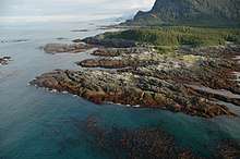 Inland Passage to Dicks Arm, view from Cape Spencer Light | |
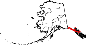
 Location within the U.S. state of Alaska | |
.svg.png) Alaska's location within the U.S. | |
| Coordinates: 58°08′00″N 135°09′00″W | |
| Country | |
| State | |
| Established | 2007[1] |
| Named for | Hoonah and Angoon |
| Largest city | Hoonah |
| Area | |
| • Total | 10,914 sq mi (28,270 km2) |
| • Land | 7,525 sq mi (19,490 km2) |
| • Water | 3,389 sq mi (8,780 km2) 31.1%% |
| Population | |
| • Estimate (2019) | 2,148 |
| • Density | 0.29/sq mi (0.11/km2) |
| Time zone | UTC−9 (Alaska) |
| • Summer (DST) | UTC−8 (ADT) |
| Congressional district | At-large |
History
The census area was significantly larger in the 1990 census, at which time it was the Skagway–Yakutat–Angoon Census Area. After Yakutat was incorporated as a consolidated-city borough on September 22, 1992, it was renamed Skagway–Hoonah–Angoon Census Area;[3] When Skagway followed suit on June 20, 2007,[4][5] the census area assumed its current name.
Geography
According to the U.S. Census Bureau, the census area has a total area of 10,914 square miles (28,270 km2), of which 7,525 square miles (19,490 km2) is land and 3,389 square miles (8,780 km2) (31.1%) is water.[6] A map showing its current boundaries is shown here:[7]
Adjacent boroughs and census areas
- Yakutat City and Borough, Alaska – northwest
- Haines Borough, Alaska – northeast
- Juneau City and Borough, Alaska – northeast
- Petersburg Borough, Alaska – southeast
- Sitka City and Borough, Alaska – southwest
- Stikine Region, British Columbia – northwest, east
- Kitimat-Stikine Regional District, British Columbia – southeast
National protected areas
- Glacier Bay National Park (part)
- Glacier Bay Wilderness (part)
- Tongass National Forest (part)
- Admiralty Island National Monument (part)
- Kootznoowoo Wilderness (part)
- Chuck River Wilderness
- Pleasant/Lemesurier/Inian Islands Wilderness
- Tracy Arm-Fords Terror Wilderness (part)
- West Chichagof-Yakobi Wilderness (part)
- Admiralty Island National Monument (part)
Demographics

- Note: Demographic data below is for the former "Skagway–Hoonah–Angoon" Census Area, which still includes Skagway Borough.
| Historical population | |||
|---|---|---|---|
| Census | Pop. | %± | |
| 2010 | 2,150 | — | |
| Est. 2019 | 2,148 | [8] | −0.1% |
| U.S. Decennial Census[9] 2010–2018[2] | |||
As of the census[10] of 2000, there were 3,436 people, 1,369 households, and 866 families residing in the census area. The population density was 0.30 people per square mile (0.12/km²). There are 2,108 housing units. The racial makeup of the census area was 58.15% White, 0.15% Black or African American, 35.01% Native American, 0.38% Asian, 0.15% Pacific Islander, 0.96% from other races, and 5.21% from two or more races. 2.82% of the population were Hispanic or Latino of any race. 3.95% reported speaking Tlingit at home, while 1.83% speak Spanish .
There were 1,369 households out of which 30.80% had children under the age of 18 living with them, 49.30% were married couples living together, 8.40% had a female householder with no husband present, and 36.70% were non-families. 30.10% of all households were made up of individuals and 5.60% had someone living alone who was 65 years of age or older. The average household size was 2.50 and the average family size was 3.14.
In the census area, the population was spread out with 26.80% under the age of 18, 7.10% from 18 to 24, 29.50% from 25 to 44, 29.30% from 45 to 64, and 7.30% who were 65 years of age or older. The median age was 38 years. For every 100 females, there were 116.40 males. For every 100 females age 18 and over, there were 120.70 males.
Communities
Cities
Census-designated places
Other unincorporated places
See also
- List of airports in the Hoonah-Angoon Census Area
References
- The census area acquired its current name in 2007, after Skagway Borough was created.
- "State & County QuickFacts". United States Census Bureau. Archived from the original on July 31, 2014. Retrieved May 18, 2014.
- Population of Alaska by Labor Market Region, Borough and Census Area, 1990–1999 Archived May 1, 2009, at the Wayback Machine, Alaska Department of Labor and Workforce Development. Accessed January 20, 2009.
- https://www.census.gov/geo/www/ansi/changenotes.html%5B%5D
- June 5, 2008 election, Skaguay News, summer edition, 2008. Page 17.
- "US Gazetteer files: 2010, 2000, and 1990". United States Census Bureau. February 12, 2011. Retrieved April 23, 2011.
- Map: Hoonah-Angoon Census Area Archived August 11, 2009, at the Wayback Machine Alaska Department of Labor
- "Population and Housing Unit Estimates". Retrieved May 13, 2019.
- "U.S. Decennial Census". United States Census Bureau. Retrieved May 18, 2014.
- "U.S. Census website". United States Census Bureau. Retrieved May 14, 2011.
External links
| Wikimedia Commons has media related to Hoonah-Angoon Census Area, Alaska. |
- Skagway-Hoonah-Angoon Census Area map, 2000 census: Alaska Department of Labor
- Hoonah-Angoon Census Area map, 2010 census: Alaska Department of Labor
- Hoonah-Angoon Census Area map, January 2014: Alaska Department of Labor
- Alaska ShoreZone Coastal Mapping and Imagery
Places adjacent to Hoonah–Angoon Census Area, Alaska | ||||||||||
|---|---|---|---|---|---|---|---|---|---|---|
| ||||||||||
Municipalities and communities of Hoonah–Angoon Census Area, Alaska, United States | ||
|---|---|---|
| Cities | Hoonah–Angoon Census Area map | |
| CDPs | ||
| Unincorporated community | ||
| Footnotes | ‡This populated place also has portions in adjacent boroughs or census areas | |
Juneau (capital) | ||
| Topics |  | |
| Society |
| |
| Regions | ||
| Largest cities pop. over 25,000 | ||
| Smaller cities pop. over 2,000 | ||
| Boroughs | ||
| Census Areas | ||
| Authority control |
|
|---|