Santa Fe County, New Mexico
Santa Fe County (Spanish: Condado de Santa Fe; meaning Holy faith in Spanish) is a county in the U.S. state of New Mexico. As of the 2010 census, the population was 144,170,[1] making it New Mexico's third-most populous county, after Bernalillo County and Doña Ana County. Its county seat is Santa Fe,[2] the state capital.
Santa Fe County | |
|---|---|
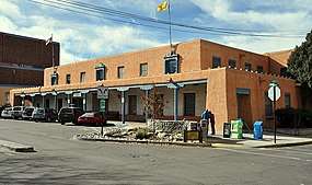 Original Santa Fe County Courthouse | |
 Flag  Seal | |
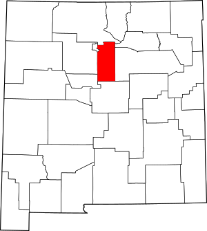 Location within the U.S. state of New Mexico | |
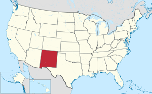 New Mexico's location within the U.S. | |
| Coordinates: 35°31′N 105°59′W | |
| Country | |
| State | |
| Founded | 1852 |
| Seat | Santa Fe |
| Largest city | Santa Fe |
| Area | |
| • Total | 1,911 sq mi (4,950 km2) |
| • Land | 1,909 sq mi (4,940 km2) |
| • Water | 1.5 sq mi (4 km2) 0.08%% |
| Population | |
| • Estimate (2019) | 150,358 |
| • Density | 76/sq mi (29/km2) |
| Time zone | UTC−7 (Mountain) |
| • Summer (DST) | UTC−6 (MDT) |
| Congressional districts | 1st, 3rd |
| Website | www |
Santa Fe County includes the Santa Fe Metropolitan Statistical Area, which is also included in the Albuquerque–Santa Fe–Las Vegas combined statistical area.
Geography
According to the U.S. Census Bureau, the county has a total area of 1,911 square miles (4,950 km2), of which 1,909 square miles (4,940 km2) is land and 1.5 square miles (3.9 km2) (0.08%) is water.[3] It is the fifth-smallest county in New Mexico by area. The highest point in the county is the summit of Santa Fe Baldy at 3,847 meters (12,621 ft). It is drained by the Rio Grande and several of its small tributaries.[4]
Adjacent counties
- Rio Arriba County - north
- Mora County - northeast
- San Miguel County - east
- Torrance County - south
- Bernalillo County - southwest
- Sandoval County - west
- Los Alamos County - northwest
National protected areas
- El Camino Real de Tierra Adentro National Historic Trail (part)
- Pecos National Historical Park (part)
- Santa Fe National Forest (part)
Demographics
| Historical population | |||
|---|---|---|---|
| Census | Pop. | %± | |
| 1910 | 14,770 | — | |
| 1920 | 15,030 | 1.8% | |
| 1930 | 19,567 | 30.2% | |
| 1940 | 30,826 | 57.5% | |
| 1950 | 38,153 | 23.8% | |
| 1960 | 44,970 | 17.9% | |
| 1970 | 53,756 | 19.5% | |
| 1980 | 75,360 | 40.2% | |
| 1990 | 98,928 | 31.3% | |
| 2000 | 129,292 | 30.7% | |
| 2010 | 144,170 | 11.5% | |
| Est. 2019 | 150,358 | [5] | 4.3% |
| U.S. Decennial Census[6] 1790-1960[7] 1900-1990[8] 1990-2000[9] 2010-2016[1] | |||
.jpg)
2000 census
As of the 2000 census,[10] The population density was 68 people per square mile (26/km²). There were 57,701 housing units at an average density of 30 per square mile (12/km²).
There were 52,482 households out of which 30.4% had children under the age of 18 living with them, 45.5% were married couples living together, 11.7% had a female householder with no husband present, and 37.5% were non-families. 29.4% of all households were made up of individuals and 7.4% had someone living alone who was 65 years of age or older. The average household size was 2.42 and the average family size was 3.01.
In the county, the population was spread out with 24.1% under the age of 18, 8.1% from 18 to 24, 29.7% from 25 to 44, 27.3% from 45 to 64, and 10.8% who were 65 years of age or older. The median age was 38 years. For every 100 females there were 95.8 males. For every 100 females age 18 and over, there were 93.4 males.
The median income for a household in the county was $42,207, and the median income for a family was $50,000. Males had a median income of $33,287 versus $27,780 for females. The per capita income for the county was $23,594. About 9.4% of families and 12% of the population were below the poverty line, including 15.2% of those under age 18 and 9.7% of those age 65 or over.
2010 census
As of the 2010 census, there were 144,170 people, 61,963 households, and 36,183 families residing in the county.[11] The population density was 75.5 inhabitants per square mile (29.2/km2). There were 71,267 housing units at an average density of 37.3 per square mile (14.4/km2).[12] The racial makeup of the county was 76.2% white, 3.1% American Indian, 1.2% Asian, 0.9% black or African American, 0.1% Pacific islander, 15.1% from other races, and 3.6% from two or more races. Those of Hispanic or Latino origin made up 50.6% of the population.[11]
The largest ancestry groups were:[13]
- 22.4% Mexican
- 11.2% German
- 11.1% Spanish
- 10.0% English
- 8.4% Irish
- 3.6% French
- 3.2% Italian
- 2.5% Scottish
- 2.3% American
- 2.1% Scotch-Irish
- 1.8% Polish
- 1.3% Swedish
- 1.3% Russian
- 1.2% Dutch
- 1.1% Norwegian
Of the 61,963 households, 26.9% had children under the age of 18 living with them, 42.1% were married couples living together, 11.0% had a female householder with no husband present, 41.6% were non-families, and 33.7% of all households were made up of individuals. The average household size was 2.28 and the average family size was 2.94. The median age was 43.0 years.[11]
The median income for a household in the county was $52,696 and the median income for a family was $64,041. Males had a median income of $41,703 versus $39,215 for females. The per capita income for the county was $32,188. About 10.0% of families and 14.4% of the population were below the poverty line, including 21.4% of those under age 18 and 7.3% of those age 65 or over.[14]
Government
The county is governed by a five-member county commission, whose members are elected from single-member districts (see map). Elections are partisan and all five seats are currently held by Democrats. County commissioners serve four-year terms, with term limits preventing them from serving more than two full terms.
Current commissioners are:
| District | Name | Party | First elected | Term ends |
|---|---|---|---|---|
| District 1 | Henry Roybal | Democratic | 2018 | 2021 |
| District 2 | Anna Hansen | Democratic | 2017 | 2020 |
| District 3 | Rudy Garcia | Democratic | 2018 | 2021 |
| District 4 | Anna Hamilton | Democratic | 2017 | 2020 |
| District 5 | Ed Moreno | Democratic | 2017 | 2020 |
The New Mexico Corrections Department and the Penitentiary of New Mexico are located in an unincorporated area in the county.[15][16]
| Year | Republican | Democratic | Third parties |
|---|---|---|---|
| 2016 | 20.1% 14,332 | 71.1% 50,793 | 8.8% 6,309 |
| 2012 | 22.4% 15,500 | 73.5% 50,872 | 4.2% 2,873 |
| 2008 | 21.9% 15,807 | 76.9% 55,567 | 1.2% 849 |
| 2004 | 27.9% 18,466 | 71.1% 47,074 | 1.0% 660 |
| 2000 | 28.3% 13,974 | 64.7% 32,017 | 7.0% 3,480 |
| 1996 | 25.6% 10,857 | 62.1% 26,349 | 12.4% 5,240 |
| 1992 | 22.6% 9,684 | 63.4% 27,189 | 14.1% 6,044 |
| 1988 | 34.9% 12,891 | 63.9% 23,581 | 1.2% 455 |
| 1984 | 46.0% 15,886 | 52.9% 18,262 | 1.2% 404 |
| 1980 | 42.9% 12,361 | 43.9% 12,658 | 13.2% 3,819 |
| 1976 | 44.5% 11,576 | 54.3% 14,127 | 1.1% 294 |
| 1972 | 52.5% 12,211 | 46.3% 10,761 | 1.2% 274 |
| 1968 | 48.1% 9,359 | 49.1% 9,544 | 2.8% 546 |
| 1964 | 31.5% 5,834 | 68.1% 12,616 | 0.4% 69 |
| 1960 | 41.4% 7,411 | 58.1% 10,385 | 0.5% 94 |
| 1956 | 56.9% 9,359 | 42.6% 6,997 | 0.5% 85 |
| 1952 | 56.6% 9,011 | 42.6% 6,786 | 0.8% 119 |
| 1948 | 54.6% 7,491 | 45.0% 6,172 | 0.5% 68 |
| 1944 | 52.7% 5,482 | 47.3% 4,915 | |
| 1940 | 49.2% 6,285 | 50.8% 6,482 | 0.0% 3 |
| 1936 | 44.6% 4,960 | 55.2% 6,145 | 0.2% 27 |
| 1932 | 38.6% 3,625 | 61.1% 5,739 | 0.3% 26 |
| 1928 | 60.3% 4,630 | 39.7% 3,051 | 0.1% 4 |
| 1924 | 59.1% 4,010 | 38.3% 2,602 | 2.6% 179 |
| 1920 | 63.9% 3,060 | 35.5% 1,700 | 0.6% 27 |
| 1916 | 56.2% 1,830 | 43.2% 1,406 | 0.7% 22 |
| 1912 | 49.4% 1,432 | 34.9% 1,012 | 15.7% 454 |
Education
There are currently 4 Schools districts in Santa Fe county:
- Española Public Schools
- Moriarty Municipal Schools
- Pojoaque Valley Public Schools
- Santa Fe Public Schools
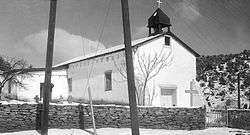
Communities
.jpg)
.jpg)
Town
Census-designated places
- Agua Fria
- Cañada de los Alamos
- Cedar Grove
- Chimayo
- Chupadero
- Cuartelez
- Cundiyo
- Cuyamungue
- Cuyamungue Grant
- El Rancho
- El Valle de Arroyo Seco
- Eldorado at Santa Fe
- Galisteo
- Glorieta
- Golden
- Jacona
- Jaconita
- La Cienega
- La Puebla
- Lamy
- Los Cerrillos
- Madrid
- Nambe
- Peak Place
- Pojoaque
- Rio Chiquito (former)
- Rio en Medio
- San Ildefonso Pueblo
- San Pedro
- Santa Cruz
- Sombrillo
- Tesuque
- Tesuque Pueblo
Other unincorporated communities
- Cañoncito
- Nambé Pueblo
- Seton Village
- Stanley
- Waldo
Ghost town
References
- "State & County QuickFacts". United States Census Bureau. Retrieved September 30, 2013.
- "Find a County". National Association of Counties. Retrieved June 7, 2011.
- "2010 Census Gazetteer Files". United States Census Bureau. August 22, 2012. Archived from the original on January 1, 2015. Retrieved January 2, 2015.
-

- "Population and Housing Unit Estimates". Retrieved December 23, 2019.
- "U.S. Decennial Census". United States Census Bureau. Retrieved January 2, 2015.
- "Historical Census Browser". University of Virginia Library. Retrieved January 2, 2015.
- "Population of Counties by Decennial Census: 1900 to 1990". United States Census Bureau. Retrieved January 2, 2015.
- "Census 2000 PHC-T-4. Ranking Tables for Counties: 1990 and 2000" (PDF). United States Census Bureau. Retrieved January 2, 2015.
- "U.S. Census website". United States Census Bureau. Retrieved January 31, 2008.
- "DP-1 Profile of General Population and Housing Characteristics: 2010 Demographic Profile Data". United States Census Bureau. Archived from the original on February 13, 2020. Retrieved January 24, 2016.
- "Population, Housing Units, Area, and Density: 2010 - County". United States Census Bureau. Archived from the original on February 13, 2020. Retrieved January 24, 2016.
- "DP02 SELECTED SOCIAL CHARACTERISTICS IN THE UNITED STATES – 2006-2010 American Community Survey 5-Year Estimates". United States Census Bureau. Archived from the original on February 13, 2020. Retrieved January 24, 2016.
- "DP03 SELECTED ECONOMIC CHARACTERISTICS – 2006-2010 American Community Survey 5-Year Estimates". United States Census Bureau. Archived from the original on February 13, 2020. Retrieved January 24, 2016.
- "Directory Archived December 9, 2009, at the Wayback Machine." New Mexico Corrections Department. Retrieved on December 7, 2009.
- "Penitentiary of New Mexico, Santa Fe." New Mexico Corrections Department. Retrieved on December 7, 2009.
- Leip, David. "Dave Leip's Atlas of U.S. Presidential Elections". uselectionatlas.org. Retrieved April 2, 2018.
External links
| Wikimedia Commons has media related to Santa Fe County, New Mexico. |
- Santa Fe County Website
- Santa Fe County Tourism Website
Places adjacent to Santa Fe County, New Mexico | ||||||||||
|---|---|---|---|---|---|---|---|---|---|---|
| ||||||||||
Municipalities and communities of Santa Fe County, New Mexico, United States | ||
|---|---|---|
| Cities | Map of New Mexico highlighting Santa Fe County | |
| Town | ||
| CDPs |
| |
| Unincorporated communities | ||
| Ghost town | ||
| Indian reservation | ||
| Footnotes | ‡This populated place also has portions in an adjacent county or counties | |
Santa Fe (capital) | ||
| Topics |
| |
| Society | ||
| Regions |
| |
| Cities | ||
| Counties | ||

| Authority control |
|
|---|