Kalispell, Montana
Kalispell (/ˈkæləˌspɛl, ˌkæləˈspɛl/) is a city in, and the county seat of Flathead County, Montana, United States.[4] The 2010 Census put Kalispell's population at 19,927.[5] The Kalispell Micropolitan Statistical Area has a population of 93,068 and it is the largest city and commercial center of northwest Montana.[6] The name Kalispell is a Salish word meaning "flat land above the lake".
Kalispell | |
|---|---|
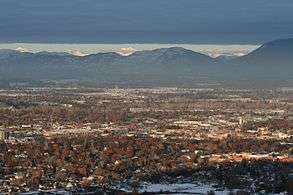 Kalispell looking northeast toward Glacier National Park from Lone Pine State Park | |
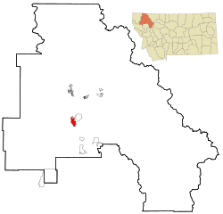 Location of Kalispell, Montana | |
| Coordinates: 48°11′52″N 114°18′58″W | |
| Country | United States |
| State | Montana |
| County | Flathead |
| Government | |
| • Mayor | Mark Johnson |
| Area | |
| • City | 11.73 sq mi (30.38 km2) |
| • Land | 11.64 sq mi (30.15 km2) |
| • Water | 0.09 sq mi (0.23 km2) |
| Elevation | 2,956 ft (901 m) |
| Population | |
| • City | 19,927 |
| • Estimate (2019)[3] | 24,565 |
| • Density | 1,700/sq mi (660/km2) |
| • Metro | 94,924 |
| Time zone | UTC−7 (Mountain (MST)) |
| • Summer (DST) | UTC−6 (MDT) |
| ZIP codes | 59901-59904 |
| Area code(s) | 406 |
| FIPS code | 30-40075 |
| GNIS feature ID | 0785622 |
| Website | Kalispell.com |
History

Working using his own capital, Charles Edward Conrad, a businessman and banker from Fort Benton, Montana, formed the Kalispell Townsite Company with three other men.[7] The townsite was quickly platted and lots began selling by the spring of 1891. Conrad built a large mansion in Kalispell in 1895.[8] Kalispell was officially incorporated as a city in 1892.[9] Since that time, the city of Kalispell has continued to grow in population reaching 19,927 in 2010. As the largest city in Northwest Montana, Kalispell serves as the county seat and commercial center of Flathead County. The city is considered a secondary trade center with a trade area of approximately 130,000. The city also is home to Kalispell Regional Medical Center, which boasts a 150-bed facility.[10]
Nestled in the Flathead valley, Kalispell is 31 miles (50 km) from Glacier National Park and 22 miles (35 km) from Hungry Horse Dam. Skiers have access to Whitefish Mountain Resort on Big Mountain and Blacktail Mountain Ski Area each 17 miles (27 km) away. Flathead Lake is 7 miles (11 km) away.[11] Buffalo Hill Golf Club, designed by Robert Muir Graves,[12] serves the needs of golfers.
The tribal schools nearby offer classes in the Kalispel–Spokane–Flathead language, a language nest, and intensive language training for adults.[13] There is a Salish language school and training center in Arlee, Montana.[14]
Heaven’s Gate (1980) was filmed in and around Kalispell.[15]
Geography and climate
Kalispell is located at 48°11′52″N 114°18′58″W (48.197801, −114.316068),[16] at an elevation of 2,956 feet (901 m).[17]
According to the United States Census Bureau, the city has a total area of 11.73 square miles (30.38 km2), of which, 11.64 square miles (30.15 km2) is land and 0.09 square miles (0.23 km2) is water.[1]
Kalispell is located 7 miles (11 km) north of Flathead Lake, which is the largest natural freshwater lake in the western United States.
The city experiences a warm-summer humid continental climate (Köppen Dfb), with long, cold and moderately snowy winters, hot and dry summers, and short springs and autumns in between. Snow usually occurs from late October/early November to March.
| Climate data for Kalispell, Montana (Glacier Park International Airport), 1981–2010 normals,[18] extremes 1899–present) | |||||||||||||
|---|---|---|---|---|---|---|---|---|---|---|---|---|---|
| Month | Jan | Feb | Mar | Apr | May | Jun | Jul | Aug | Sep | Oct | Nov | Dec | Year |
| Record high °F (°C) | 56 (13) |
64 (18) |
73 (23) |
85 (29) |
95 (35) |
102 (39) |
104 (40) |
105 (41) |
99 (37) |
86 (30) |
69 (21) |
58 (14) |
105 (41) |
| Mean maximum °F (°C) | 44.9 (7.2) |
48.3 (9.1) |
60.6 (15.9) |
73.6 (23.1) |
82.4 (28.0) |
87.2 (30.7) |
93.6 (34.2) |
94.1 (34.5) |
85.4 (29.7) |
71.7 (22.1) |
55.1 (12.8) |
44.8 (7.1) |
96.1 (35.6) |
| Average high °F (°C) | 31.2 (−0.4) |
36.0 (2.2) |
45.6 (7.6) |
56.1 (13.4) |
65.1 (18.4) |
72.0 (22.2) |
81.4 (27.4) |
81.4 (27.4) |
69.9 (21.1) |
54.9 (12.7) |
39.6 (4.2) |
29.7 (−1.3) |
55.3 (12.9) |
| Average low °F (°C) | 16.4 (−8.7) |
18.2 (−7.7) |
25.1 (−3.8) |
31.2 (−0.4) |
38.5 (3.6) |
44.5 (6.9) |
48.0 (8.9) |
46.5 (8.1) |
38.4 (3.6) |
29.4 (−1.4) |
24.0 (−4.4) |
15.8 (−9.0) |
31.4 (−0.3) |
| Mean minimum °F (°C) | −8.8 (−22.7) |
−3.4 (−19.7) |
10.1 (−12.2) |
20.0 (−6.7) |
26.0 (−3.3) |
32.7 (0.4) |
37.4 (3.0) |
36.1 (2.3) |
27.4 (−2.6) |
15.1 (−9.4) |
5.0 (−15.0) |
−6.6 (−21.4) |
−18.0 (−27.8) |
| Record low °F (°C) | −38 (−39) |
−36 (−38) |
−29 (−34) |
−5 (−21) |
17 (−8) |
26 (−3) |
30 (−1) |
30 (−1) |
7 (−14) |
−4 (−20) |
−22 (−30) |
−35 (−37) |
−38 (−39) |
| Average precipitation inches (mm) | 1.33 (34) |
0.97 (25) |
1.09 (28) |
1.24 (31) |
1.98 (50) |
2.56 (65) |
1.45 (37) |
0.99 (25) |
1.38 (35) |
1.01 (26) |
1.43 (36) |
1.56 (40) |
16.99 (432) |
| Average snowfall inches (cm) | 12.7 (32) |
7.9 (20) |
5.7 (14) |
2.2 (5.6) |
0.2 (0.51) |
0.3 (0.76) |
0 (0) |
0 (0) |
trace | 1.1 (2.8) |
9.3 (24) |
16.3 (41) |
55.7 (141) |
| Average precipitation days (≥ 0.01 in) | 13.7 | 10.8 | 11.8 | 10.7 | 12.4 | 12.5 | 7.7 | 7.3 | 8.2 | 9.3 | 13.0 | 14.4 | 131.8 |
| Average snowy days (≥ 0.1 in) | 10.5 | 7.7 | 5.2 | 2.7 | 0.3 | 0.1 | 0 | 0 | 0 | 1.2 | 7.4 | 11.8 | 46.9 |
| Source: NOAA,[19][20] | |||||||||||||
Demographics
| Historical population | |||
|---|---|---|---|
| Census | Pop. | %± | |
| 1890 | 1,000 | — | |
| 1900 | 2,526 | 152.6% | |
| 1910 | 5,549 | 119.7% | |
| 1920 | 5,147 | −7.2% | |
| 1930 | 6,094 | 18.4% | |
| 1940 | 8,425 | 38.3% | |
| 1950 | 9,737 | 15.6% | |
| 1960 | 10,151 | 4.3% | |
| 1970 | 10,526 | 3.7% | |
| 1980 | 10,648 | 1.2% | |
| 1990 | 11,917 | 11.9% | |
| 2000 | 14,223 | 19.4% | |
| 2010 | 19,927 | 40.1% | |
| Est. 2019 | 24,565 | [3] | 23.3% |
| source:[5][21] | |||
2010 census
As of the census[2] of 2010, there were 19,927 people, 8,638 households, and 4,944 families living in the city. The population density was 1,711.9 inhabitants per square mile (661.0/km2). There were 9,379 housing units at an average density of 805.8 per square mile (311.1/km2). The racial makeup of the city was 94.2% White, 0.2% African American, 1.3% Native American, 1.0% Asian, 0.1% Pacific Islander, 0.6% from other races, and 2.6% from two or more races. Hispanic or Latino of any race were 2.9% of the population.
There were 8,638 households of which 30.8% had children under the age of 18 living with them, 40.4% were married couples living together, 12.0% had a female householder with no husband present, 4.8% had a male householder with no wife present, and 42.8% were non-families. 35.7% of all households were made up of individuals and 14.4% had someone living alone who was 65 years of age or older. The average household size was 2.26 and the average family size was 2.94.
The median age in the city was 34.5 years. 25.1% of residents were under the age of 18; 9.5% were between the ages of 18 and 24; 27.2% were from 25 to 44; 22.7% were from 45 to 64; and 15.4% were 65 years of age or older. The gender makeup of the city was 47.3% male and 52.7% female.
2000 census
As of the census of 2000, there were 14,223 people, 6,142 households, and 3,494 families living in the city. The population density was 2,605.7 people per square mile (1,005.8/km²). There were 6,532 housing units at an average density of 1,196.7 per square mile (461.9/km²). The racial makeup of the city was 95.84% White, 0.28% African American, 1.22% Native American, 0.56% Asian, 0.04% Pacific Islander, 0.39% from other races, and 1.66% from two or more races. Hispanic or Latino of any race were 1.55% of the population. 21.7% were of German, 12.0% Irish, 11.3% Norwegian, 10.7% English and 6.6% United States or American ancestry.
There were 6,142 households out of which 28.9% had children under the age of 18 living with them, 42.0% were married couples living together, 11.2% had a female householder with no husband present, and 43.1% were non-families. 36.8% of all households were made up of individuals and 15.5% had someone living alone who was 65 years of age or older. The average household size was 2.209 and the average family size was 2.92.
In the city, the age distribution of the population shows 24.0% under the age of 18, 10.0% from 18 to 24, 26.8% from 25 to 44, 20.9% from 45 to 64, and 18.3% who were 65 years of age or older. The median age was 38 years. For every 100 females, there were 87.7 males. For every 100 females age 18 and over, there were 82.1 males.
The median income for a household in the city was $28,567, and the median income for a family was $36,554. Males had a median income of $29,431 versus $20,122 for females. The per capita income for the city was $16,224. About 10.1% of families and 15.9% of the population were below the poverty line, including 17.1% of those under age 18 and 13.0% of those age 65 or over.
Economy
Kalispell is home to the headquarters of the Montana Rifle Company.
Education
Kalispell has a public library, a branch of the Flathead County Library.[23]
Transportation
Kalispell is located at the intersection of U.S. Routes 2 and 93. Commercial air service is offered at Glacier Park International Airport, located approximately 8 miles (13 km) northeast of Kalispell off U.S. Route 2 between Kalispell and Columbia Falls.[24]
Kalispell City Airport, located in the southern part of the city, offers general aviation service.[25]
Amtrak's Empire Builder service between Chicago and either Seattle, Washington, or Portland, Oregon, is available in Whitefish, approximately 15 miles (24 km) north.
Eagle Transit, an agency of Flathead County, offers local transit service within and connecting Kalispell, Columbia Falls and Whitefish, as well as paratransit demand-responsive service.[26]
Agriculture
As of July 2014, one of Montana's last mint farms, growing peppermint and spearmint, is located near Kalispell.[27]
Local media
Kalispell is one of the largest media markets in Montana. It is the second largest over the air radio market in Montana, behind only Billings.[28]
Notable people
- Ruth Anderson, composer
- James E. Atwater, retired chemist and geophysicist
- Chuck Baldwin, former candidate for President under the Constitution Party
- Brad Bird, Academy Award-winning director of animated films and television programs
- Asta Bowen, author
- Robert Bray, film and television actor
- Jaime Clarke, novelist and editor
- John Corapi, former Catholic priest and speaker
- Shane Bitney Crone, activist, filmmaker, writer, speaker for LGBT Rights
- William Cumming, 20th century artist and founder of Northwest School
- Rick Dennison, offensive coordinator of NFL's Buffalo Bills, Denver Broncos
- John Edward Erickson, Governor of Montana
- Flip Gordon, professional wrestler
- Robin Lee Graham, circumnavigated the world at age 16
- Frank Hagel, painter and sculptor
- Tanner Hall, professional skier, Winter X-Games gold medalist in Slope-Style, Big Air and Half-pipe
- T. J. Hileman, photographer of Glacier National Park
- Lex Hilliard, NFL player, New York Jets fullback
- L. Ron Hubbard, author and founder of Scientology
- Dorothy M. Johnson, noted author of Western fiction
- Amanda Kimmel, Survivor: China, Micronesia, and Heroes vs. Villains contestant
- Brad Ludden, professional kayaker
- Sam McCullum, former NFL football player
- Dylan McFarland, former Buffalo Bills offensive lineman
- Andrew J. Moonen, former employee of Blackwater USA accused of murder in Iraq
- Mary Oppen, activist, photographer, wife of George Oppen
- Brock Osweiler, NFL quarterback for Denver Broncos, Cleveland Browns
- Daniel Parker, sculptor and painter
- Charlotte Pendragon, magician/entertainer
- Eugene H. Peterson, author of The Message, a contemporary rendition of the Bible
- Shadi Petosky, author and television producer
- Ace Powell, painter and sculptor
- Mike Reilly, NFL quarterback, CFL quarterback, BC Lions, Edmonton Eskimos
- Alice Ritzman, former LPGA golf professional
- Monsignor Alexander King Sample, Roman Catholic Archbishop of Portland, Oregon
- Robert Burns Smith, Governor of Montana
- Thatcher Szalay, former Seattle Seahawks offensive lineman
- Misty Upham (1982-2014), actress
- Michelle Williams, actress
References
- "US Gazetteer files 2010". United States Census Bureau. Archived from the original on July 2, 2012. Retrieved December 18, 2012.
- "U.S. Census website". United States Census Bureau. Retrieved December 18, 2012.
- "Population and Housing Unit Estimates". Retrieved May 21, 2020.
- "Find a County". National Association of Counties. Archived from the original on May 31, 2011. Retrieved June 7, 2011.
- "Kalispell (city) QuickFacts from the US Census Bureau". Quickfacts.census.gov. Archived from the original on December 20, 2013. Retrieved December 20, 2013.
- "Flathead County QuickFacts from the US Census Bureau". Quickfacts.census.gov. Archived from the original on June 6, 2011. Retrieved December 20, 2013.
- "History of the Courthouse". County of Flathead. Archived from the original on April 26, 2012. Retrieved December 5, 2011.
- "Conrad Mansion Museum". Archived from the original on October 5, 2016. Retrieved October 4, 2016.
- "Brief History of the Flathead Valley". Flathead Convention & Visitor Bureau. Archived from the original on July 6, 2006. Retrieved November 23, 2011.
- "About Us : Kalispell Regional Medical Center : Northwest Healthcare". Nwhc.org. Archived from the original on April 10, 2012. Retrieved December 20, 2013.
- "Kalispell Montana History". Kalispellmontana.com. December 16, 2013. Archived from the original on December 21, 2013. Retrieved December 20, 2013.
- "Graves one of handful who designs courses". The Daily Inter Lake. June 27, 1976.
- "Language". Kalispel Tribe. Archived from the original on May 2, 2014. Retrieved February 18, 2013.
- "Welcome to the Nk̓ʷusm Website - Nḱwusm Salish School". www.salishschool.org. Archived from the original on November 22, 2015. Retrieved September 22, 2015.
- Maddrey, Joseph (2016). The Quick, the Dead and the Revived: The Many Lives of the Western Film. McFarland. Page 184. ISBN 9781476625492.
- "US Gazetteer files: 2010, 2000, and 1990". United States Census Bureau. February 12, 2011. Retrieved April 23, 2011.
- "Kalispell". Geographic Names Information System. United States Geological Survey.
- Mean monthly maxima and minima (i.e. the expected highest and lowest temperature readings at any point during the year or given month) calculated based on data at said location from 1981 to 2010.
- "NowData - NOAA Online Weather Data". National Oceanic and Atmospheric Administration. Archived from the original on July 24, 2014. Retrieved March 15, 2018.
- "Station Name: MT KALISPELL GLACIER AP". National Oceanic & Atmospheric Administration. Retrieved March 15, 2018.
- Moffatt, Riley. Population History of Western U.S. Cities & Towns, 1850-1990. Lanham: Scarecrow, 1996, 128.
- United States Census Bureau. "Census of Population and Housing". Retrieved May 31, 2014.
- "Montana Public Libraries". PublicLibraries.com. Archived from the original on March 26, 2019. Retrieved June 14, 2019.
- "City of Kalispell - Home". Kalispell.Com. Archived from the original on December 22, 2013. Retrieved December 20, 2013.
- Kalispell. "Kalispell airport information at Skyscanner". Kalispell: Skyscanner.com. Archived from the original on December 21, 2013. Retrieved December 20, 2013.
- Flathead County Government. "Flathead County Eagle Transit". Flathead.mt.gov. Archived from the original on December 21, 2013. Retrieved December 20, 2013.
- Priddy, Molly (July 6, 2014). "Creston man is one of Montana's last mint farmers". Missoulian. Archived from the original on July 9, 2014. Retrieved July 9, 2014.
- "Arbitron Radio Market Rankings - Fall 2011". Arbitron.com. October 14, 2009. Archived from the original on October 16, 2010. Retrieved December 20, 2013.
- "Daily Inter Lake". www.dailyinterlake.com. Archived from the original on January 14, 2020. Retrieved January 20, 2020.
- "Flathead Beacon - News for Montana's Flathead Valley". Flathead Beacon. Archived from the original on December 20, 2013. Retrieved January 20, 2020.
External links
| Wikimedia Commons has media related to Kalispell, Montana. |

- City of Kalispell
- Historic Downtown Kalispell
- Kalispell Chamber of Commerce
- Kalispell Montana info about All Glacier National Park
Municipalities and communities of Flathead County, Montana, United States | ||
|---|---|---|
| Cities | 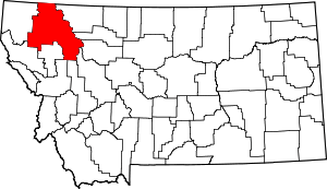 Flathead County map | |
| CDPs | ||
| Unincorporated communities | ||
| Indian reservation | ||
| Ghost town | ||
| Footnotes | ‡This populated place also has portions in an adjacent county or counties | |
| Authority control |
|
|---|