Yethonat, Washington
| Yethonat, Washington | |
|---|---|
| Unincorporated community | |
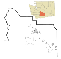 Yethonat, Washington Location of Yethonat, Washington  Yethonat, Washington Yethonat, Washington (Washington (state)) | |
| Coordinates: 46°24′16″N 120°23′47″W / 46.4045725°N 120.3964478°WCoordinates: 46°24′16″N 120°23′47″W / 46.4045725°N 120.3964478°W[1] | |
| Country | United States |
| State | Washington |
| County | Yakima |
| Elevation[2] | 810 ft (247 m) |
| Time zone | UTC-8 (Pacific (PST)) |
| • Summer (DST) | UTC-7 (PDT) |
| ZIP code | 98951 |
| Area code(s) | 509 |
| GNIS feature ID | 1511444[2] |
Yethonat is an unincorporated community in Yakima County, Washington, United States. The community developed along the Toppenish, Simcoe and Western Railway Company line.[3] Yethonat is located between Wapato and Toppenish off U.S. Route 97 and is a small, rural agricultural community.
References
- ↑ "Yethonat". Geographic Names Information System. United States Geological Survey. Retrieved 2012-10-25.
- 1 2 "US Board on Geographic Names". United States Geological Survey. 2007-10-25. Retrieved 2008-01-31.
- ↑ "Station Roster Master List: Yethonat". Northern Pacific Railway Historical Association. Retrieved October 25, 2012.
Municipalities and communities of Yakima County, Washington, United States | ||
|---|---|---|
| Cities | 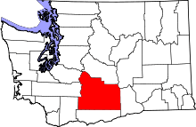 | |
| Towns | ||
| CDPs | ||
| Other unincorporated communities | ||
| Indian reservation | ||
| Footnotes | ‡This populated place also has portions in an adjacent county or counties | |

This article is issued from
Wikipedia.
The text is licensed under Creative Commons - Attribution - Sharealike.
Additional terms may apply for the media files.