Midvale, Washington
| Midvale, Washington | |
|---|---|
| Unincorporated community | |
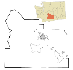 Midvale, Washington Location of Midvale, Washington  Midvale, Washington Midvale, Washington (Washington (state)) | |
| Coordinates: 46°17′03″N 120°00′52″W / 46.2842978°N 120.0144869°WCoordinates: 46°17′03″N 120°00′52″W / 46.2842978°N 120.0144869°W[1] | |
| Country | United States |
| State | Washington |
| County | Yakima |
| Elevation[2] | 692 ft (211 m) |
| Time zone | UTC-8 (Pacific (PST)) |
| • Summer (DST) | UTC-7 (PDT) |
| ZIP code | 98938 |
| Area code(s) | 509 |
| GNIS feature ID | 1511150[2] |
Midvale is an unincorporated community in Yakima County, Washington, United States, located immediately south of Sunnyside.
The community was named Midvale by the Union Pacific Railroad because of its location midway between Mabton and Sunnyside.[3]
References
- ↑ "Midvale". Geographic Names Information System. United States Geological Survey. Retrieved 2012-10-25.
- 1 2 "US Board on Geographic Names". United States Geological Survey. 2007-10-25. Retrieved 2008-01-31.
- ↑ "Washington Place Names database". Tacoma Public Library. Archived from the original on September 5, 2012. Retrieved October 26, 2012.
Municipalities and communities of Yakima County, Washington, United States | ||
|---|---|---|
| Cities | 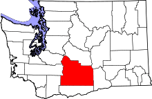 | |
| Towns | ||
| CDPs | ||
| Other unincorporated communities | ||
| Indian reservation | ||
| Footnotes | ‡This populated place also has portions in an adjacent county or counties | |

This article is issued from
Wikipedia.
The text is licensed under Creative Commons - Attribution - Sharealike.
Additional terms may apply for the media files.