Keelung
| Keelung 基隆市 | |||
|---|---|---|---|
| City | |||
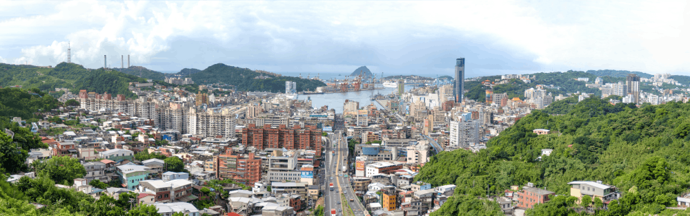
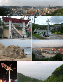 Top: A panoramic view of downtown Keelung and Keelung Port Second left: Main gate of Chung Cheng Park | |||
| |||
| Nickname(s): The Rainy Port (雨港) | |||
 | |||
| Coordinates: 25°08′N 121°44′E / 25.133°N 121.733°ECoordinates: 25°08′N 121°44′E / 25.133°N 121.733°E | |||
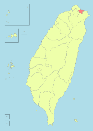
| Country | Taiwan (Republic of China) | ||
| Region | Northern Taiwan | ||
| Districts | 7 | ||
| City seat | Zhongzheng District | ||
| Government | |||
| • Mayor | Lin Yu-chang (DPP) | ||
| • Deputy Mayor | Lin Yong-fa[1] | ||
| Area | |||
| • Total | 132.7589 km2 (51.2585 sq mi) | ||
| Area rank | 18 of 22 | ||
| Population (2016)[2] | |||
| • Total | 371,878 | ||
| • Rank | 16 of 22 | ||
| • Density | 2,800/km2 (7,300/sq mi) | ||
| Time zone | UTC+8 (National Standard Time) | ||
| Postal code | 200-206 | ||
| Area code(s) | (0)32 | ||
| - Bird | Eagle | ||
| - Flower | Common crepe myrtle | ||
| - Tree | Formosan Sweet-gum | ||
| English | Keelung/KLC | ||
| Chinese | 基隆/基市 | ||
| Website | klcg.gov.tw | ||


| Keelung | |||||||||||||
| Chinese name | |||||||||||||
|---|---|---|---|---|---|---|---|---|---|---|---|---|---|
| Chinese | 基隆市 | ||||||||||||
| |||||||||||||
| Taiwanese Hokkien Name | |||||||||||||
| Traditional Chinese | 雞籠市 | ||||||||||||
| Simplified Chinese | 鸡笼市 | ||||||||||||
| |||||||||||||
| Japanese name | |||||||||||||
| Kanji | 基隆市 | ||||||||||||
| Kana | キールンし | ||||||||||||
| |||||||||||||
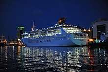
Keelung, officially known as Keelung City (Chinese: 基隆市), is a major port city situated in the northeastern part of Taiwan. It borders New Taipei with which it forms the Taipei–Keelung metropolitan area, along with Taipei itself. Nicknamed the Rainy Port for its frequent rain and maritime role, the city is Taiwan's second largest seaport (after Kaohsiung).
Name
According to early Chinese accounts, this northern coastal area was originally called Pak-kang (Chinese: 北港; Pe̍h-ōe-jī: Pak-káng).[3] By the early 20th century, the city was known to the Western world as Kelung,[4] as well as the variants Kiloung, Kilang and Keelung.[5] In his 1903 general history of Taiwan, US Consul to Formosa (1898–1904) James W. Davidson related that "Kelung" was among the few well-known names, thus warranting no alternate Japanese romanization.[6]
However, the Taiwanese people have long called the city Kelang (Chinese: 雞籠; Pe̍h-ōe-jī: Ke-lâng/Koe-lâng; literally: "rooster cage" or "hencoop"[7]). It has been proposed that this name was derived from the local mountain that took the shape of a rooster cage. However, it is more probable that the name was derived from the first inhabitants of the region, as are the names of many other Taiwanese cities. In this case, the Ketagalan people were the first inhabitants, and early Han settlers probably approximated "Ketagalan" with Ke-lâng (Hokkien phonetics).
In 1875, during the late Qing era, a new official name was given (Chinese: 基隆; pinyin: Jīlóng; literally: "base prosperous").[8] In Mandarin, probably the working language of Chinese government at the time, both the old and new names were likely pronounced Kīlóng (hence "Keelung").
Under Japanese rule (1895–1945), the city was also known to the west by the Japanese romanization Kīrun (also written as Kirun or Kiirun[9]).
In Standard Chinese, which became the official language of Taiwan after its handover to the Republic of China, the newer name is read Jīlóng (the shift from initial K to J is a recent development in the Beijing dialect, see Old Mandarin). However, the locals continue to call the city Ke-lâng across the changes in government.[10][11]
History

Keelung was first inhabited by the Ketagalan, a tribe of Taiwanese aborigine. The Spanish expedition to Formosa in the early 17th century was its first contact with the West; by 1624 the Spanish had built San Salvador de Quelung, a fort in Keelung serving as an outpost of the Manila-based Spanish East Indies.[12] The Spanish ruled it as a part of Spanish Formosa. From 1642 to 1661 and 1663–1668, Keelung was under Dutch control.[13][14] The Dutch East India Company took over the Spanish Fort San Salvador at Santissima Trinidad. They reduced its size and renamed it Fort Noort-Hollant.[14] The Dutch had three more minor fortifications in Keelung and also a little school and a preacher.
Kingdom of Tungning
When Ming Dynasty loyalist Koxinga successfully attacked the Dutch in southern Taiwan (Siege of Fort Zeelandia), the crew of the Keelung forts fled to the Dutch trading post in Japan. The Dutch came back in 1663 and re-occupied and strengthened their earlier forts. However, trade with Qing China through Keelung was not what they hoped it would be and, in 1668, they left after getting harassed by aboriginals.[15]
Qing dynasty
First Opium War
Given the strategic and commercial value of Taiwan, there were British suggestions in 1840 and 1841 to seize the island.[16][17] In September 1841, during the First Opium War, the British transport ship Nerbudda became shipwrecked near Keelung Harbour due to a typhoon. The brig Ann also became shipwrecked in March 1842. Most of the crew were Indian lascars. Survivors from both ships were transferred by authorities to the capital Tainan. The Taiwan Qing commanders, Ta-hung-ah and Yao Ying, filed a disingenuous report to the emperor, claiming to have defended against an attack from the Keelung fort. In October 1841, HMS Nimrod sailed to Keelung to search for the Nerbudda survivors, but after Captain Joseph Pearse found out that they were sent south for imprisonment, he ordered the bombardment of the harbour and destroyed 27 sets of cannon before returning to Hong Kong. Most of the survivors—over 130 from the Nerbudda and 54 from the Ann—were executed in Tainan in August 1842.[16]
In 1863, the Qing Empire opened up Keelung as a trading port and the city enjoyed rapid development due to the abundant commodities such as placer gold and high quality coal found in the drainage area of Keelung River. In 1875, Taipeh Prefecture was created and included Keelung. In 1878, Keelung was formed into a ting or sub-prefecture.[18] Around the same time, the name was changed from Ke-lang (雞籠廳) to Kilong (基隆廳), which means "rich and prosperous land".[8]
Sino-French War
During the Sino-French War (1884–85), the French attempted an invasion of Taiwan during the Keelung Campaign. Liu Mingchuan, who led the defence of Taiwan, recruited Aboriginals to serve alongside the Chinese soldiers in fighting against the French of Colonel Jacques Duchesne's Formosa Expeditionary Corps. The French were defeated at the Battle of Tamsui and the Qing forces pinned the French down at Keelung in an eight-month-long campaign before the French withdrew.
Empire of Japan
A systematic city development started during the Japanese Era, after the 1895 Treaty of Shimonoseki, which handed all Taiwan over to Japan. A five-phase construction of Keelung Harbor was initiated, and in by 1916 trade volume had exceeded even those of Tamsui and Kaohsiung Harbors to become one of the major commercial harbors of Taiwan.[19]
Keelung was governed as Kīrun Town (基隆街), Kīrun District, Taihoku Prefecture in 1920 and was upgraded to a city in 1924.[19] The Pacific War broke out in 1941, and Keelung became one of the first targets of Allied bombers and was nearly destroyed as a result.[19]
Republic of China
After the withdrawal of the Japanese, Taiwan became part of the Republic of China (ROC) in October 1945, Keelung was established as a provincial city of Taiwan Province. The Keelung City Government worked with the harbor bureau to rebuild the city and the harbor and in 1984, the harbor became the 7th largest container harbor in the world.[20]
Geography
Keelung City is located in the northern part of Taiwan Island. It occupies an area of 132.76 km2 (51.26 sq mi) and is separated from its neighboring county by mountains in the east, west and south. The northern part of the city faces the ocean and is a great deep water harbor since early times.[21]
Climate
Keelung has a humid subtropical climate (Köppen Cfa) with a yearly rainfall average upwards of 3,700 millimetres (146 in). It has long been noted as one of the wettest and gloomiest cities in the world; the effect is related to the Kuroshio Current.[22] Although it is one of the coolest cities of Taiwan, winters are still short and warm, whilst summers are long, relatively dry and hot, temperatures can peek above 26 °C during a warm winter day, while it can dip below 27 °C during a rainy summer day, much like the rest of northern Taiwan. However its location on northern mountain slopes means that due to orographic lift, rainfall is heavier during fall and winter, the latter during which a northeasterly flow prevails. During summer, southwesterly winds dominate and thus there is a slight rain shadow effect. Fog is most serious during winter and spring, when relative humidity levels are also highest.
| Climate data for Keelung | |||||||||||||
|---|---|---|---|---|---|---|---|---|---|---|---|---|---|
| Month | Jan | Feb | Mar | Apr | May | Jun | Jul | Aug | Sep | Oct | Nov | Dec | Year |
| Record high °C (°F) | 32.1 (89.8) |
31.2 (88.2) |
33.0 (91.4) |
35.2 (95.4) |
37.3 (99.1) |
37.6 (99.7) |
38.8 (101.8) |
38.2 (100.8) |
36.8 (98.2) |
34.3 (93.7) |
32.4 (90.3) |
30.0 (86) |
38.8 (101.8) |
| Average high °C (°F) | 18.3 (64.9) |
18.8 (65.8) |
20.8 (69.4) |
24.4 (75.9) |
27.7 (81.9) |
30.7 (87.3) |
33.0 (91.4) |
32.3 (90.1) |
29.6 (85.3) |
26.2 (79.2) |
23.3 (73.9) |
19.9 (67.8) |
25.4 (77.7) |
| Daily mean °C (°F) | 16.0 (60.8) |
16.2 (61.2) |
17.9 (64.2) |
21.3 (70.3) |
24.5 (76.1) |
27.3 (81.1) |
29.3 (84.7) |
28.9 (84) |
27.0 (80.6) |
24.1 (75.4) |
21.2 (70.2) |
17.7 (63.9) |
22.6 (72.7) |
| Average low °C (°F) | 13.9 (57) |
14.2 (57.6) |
15.5 (59.9) |
18.8 (65.8) |
22.0 (71.6) |
24.6 (76.3) |
26.4 (79.5) |
26.2 (79.2) |
24.7 (76.5) |
22.2 (72) |
19.2 (66.6) |
15.7 (60.3) |
20.3 (68.5) |
| Record low °C (°F) | 3.9 (39) |
5.6 (42.1) |
3.9 (39) |
9.2 (48.6) |
13.9 (57) |
16.7 (62.1) |
21.4 (70.5) |
20.1 (68.2) |
17.1 (62.8) |
12.2 (54) |
9.7 (49.5) |
4.6 (40.3) |
3.9 (39) |
| Average rainfall mm (inches) | 335.8 (13.22) |
399.1 (15.713) |
332.3 (13.083) |
240.9 (9.484) |
296.1 (11.657) |
286.7 (11.287) |
150.4 (5.921) |
212.8 (8.378) |
360.8 (14.205) |
413.4 (16.276) |
394.7 (15.539) |
332.1 (13.075) |
3,755.1 (147.838) |
| Average rainy days (≥ 0.1 mm) | 21.0 | 19.6 | 21.1 | 17.2 | 18.8 | 14.2 | 9.2 | 11.5 | 15.0 | 17.7 | 19.9 | 20.1 | 205.3 |
| Average relative humidity (%) | 81.2 | 82.5 | 83.6 | 81.6 | 81.7 | 79.6 | 75.1 | 76.7 | 78.6 | 79.2 | 79.0 | 78.5 | 79.8 |
| Mean monthly sunshine hours | 54.5 | 48.0 | 65.6 | 83.4 | 90.3 | 125.4 | 203.0 | 192.5 | 149.1 | 94.3 | 58.7 | 52.6 | 1,217.4 |
| Source: [23] | |||||||||||||
Administration
Zhongzheng District is the seat of Keelung City which houses the Keelung City Government and Keelung City Council. The current Mayor of Keelung is Lin Yu-chang of the Democratic Progressive Party.
Administrative divisions
Keelung has seven (7) districts:
| Map | Name | Chinese | Taiwanese | Hakka | Population (2016) | Area (km²) | |
|---|---|---|---|---|---|---|---|
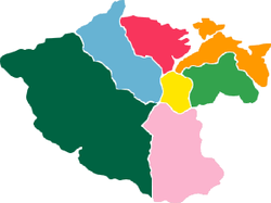 |
Zhongzheng | 中正區 | Tiong-chèng | Tsûng-tsang | 52,689 | 10.2118 | |
| Zhongshan | 中山區 | Tiong-san | Tsûng-sân | 48,369 | 10.5238 | ||
| Ren'ai | 仁愛區 | Jîn-ài | Yìn-oi | 45,563 | 4.2335 | ||
| Xinyi | 信義區 | Sìn-gī | Sin-ngi | 51,621 | 10.6706 | ||
| Anle | 安樂區 | An-lo̍k | Ôn-lo̍k | 81,298 | 18.0250 | ||
| Nuannuan | 暖暖區 | Lóan-lóan | Nôn-nôn | 38,393 | 22.8283 | ||
| Qidu | 七堵區 | Chhit-tó͘ | Tshit-tù | 54,086 | 56.2659 | ||
Politics
Keelung City voted one Democratic Progressive Party legislator to be in the Legislative Yuan during the 2016 Republic of China legislative election.[24]
Demographics and culture
| Historical population | ||
|---|---|---|
| Year | Pop. | ±% |
| 1897 | 9,500 | — |
| 1904 | 17,710 | +86.4% |
| 1924 | 58,000 | +227.5% |
| 1943 | 100,000 | +72.4% |
| 1944 | 92,000 | −8.0% |
| 1948 | 130,000 | +41.3% |
| 1971 | 330,000 | +153.8% |
| 1985 | 351,524 | +6.5% |
| 1990 | 352,919 | +0.4% |
| 1995 | 368,771 | +4.5% |
| 2000 | 388,425 | +5.3% |
| 2005 | 390,633 | +0.6% |
| 2010 | 384,134 | −1.7% |
| 2015 | 372,105 | −3.1% |
| Source: "Populations by city and country in Taiwan". Ministry of the Interior Population Census. | ||
Population growth
| Year | Population | Notes |
|---|---|---|
| Ranked 6th[25] | ||
| Decrease due to Allied air bombings | ||
| 28,000 Mainlander influx | ||
Festivals
One of the most popular festivals in Taiwan is the Mid-Summer Ghost Festival. The Keelung Ghost Festival is among the oldest in Taiwan, dating back to 1851 after bitter clashes between rivaling clans, which claimed many lives before mediators stepped in. The Ghost Festival of Keelung City is a reflection of Taiwan's rich cultural history that is very much alive today.[26]
Economy
Coal mining peaked in 1968. The city developed quickly and by 1984, the harbor was the 7th largest container harbor in the world.[20]
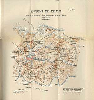 Keelung Port Croquis (in 1894)
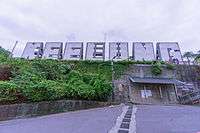 Keelung Landmark
Education
Education in Keelung City is governed by the Department of Education of Keelung City Government.
Universities and colleges
Keelung City houses several universities and colleges, such as the National Taiwan Ocean University, Ching Kuo Institute of Management and Health and Chungyu Institute of Technology.
High schools
Energy
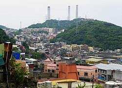
Keelung City houses the only fully oil-fired power plant in Taiwan, the Hsieh-ho Power Plant, which is located in Zhongshan District. The installed capacity of the power plant is 2,000 MW.
Tourist attractions
Ports
Parks
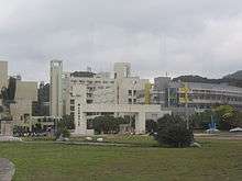
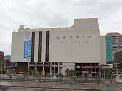
Cultural centers
Embrace Cultural and Creative Park and Keelung Cultural Center.
Museums
Historical structures
Baimiweng Fort, Dawulun Fort, Gongzi Liao Fort, Keelung Fort Commander's Official Residence, Pengjia Lighthouse and Uhrshawan Battery.
Transportation
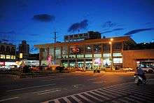
Rail
The Taiwan Railways Administration stations of Badu Station, Baifu Station, Keelung Station, Nuannuan Station, Qidu Station and Sankeng Station cross Keelung City.
Water
Taiwan's second largest port, the Port of Keelung, is located in the city. The port serves for destinations to Matsu Islands, Xiamen and Okinawa.
International relations
Twin towns — Sister cities
Keelung is twinned with:


People from Keelung
- Chen Ti, Taiwanese tennis player
- Zero Chou, Taiwanese director
- Jiang Yi-huah, Premier of the Republic of China
- Show Lo, Taiwanese entertainer
- Danson Tang, Taiwanese Mandopop singer
- Yi Huan, Taiwanese comic creator/animator
- Feng-hsuing Hsu, American-Taiwanese computer scientist
- Hsie Zhen-Wu, Taiwanese TV presenter/lawyer
- Fu-jie Guo, American-Taiwanese computer scientist
See also
References
- ↑ "Deputy Mayor". Keelung City Government. Archived from the original on 27 December 2014. Retrieved 17 December 2016.
- ↑ 人口統計. www.klcg.gov.tw (in Chinese). Archived from the original on 29 May 2016. Retrieved 6 June 2016.
- ↑ Campbell, William (1903). "Explanatory Notes". Formosa under the Dutch: described from contemporary records, with explanatory notes and a bibliography of the island. London: Kegan Paul. pp. 538–557. OCLC 644323041.
- ↑ for example: Smith, D. Warres (1900). European settlements in the Far East: China, Japan, Corea, Indo-China, Straits Settlements, Malay States, Siam, Netherlands, India, Borneo, the Philippines etc. S. Low, Marston & company. p. 38. OCLC 3110223. OL 6905314M.
- ↑ Davidson (1903), Index p.20.
- ↑ Davidson (1903), p. iii.
- ↑ "Welcome to Keelung City: The Beginning". Keelung City Government. Archived from the original on 26 September 2009. Retrieved 2010-07-24.
- 1 2 "Ching Dynasty". Keelung City Government. Archived from the original on 26 May 2010. Retrieved 2010-07-24.
- ↑ Terry, Thomas Philip (1914). Terry's Japanese Empire. Houghton Mifflin Company. p. 774. OCLC 51414323. OL 18847607M.
- ↑ Governor-General of Taiwan (1931–1932). "koe-lâng (基隆)". In Ogawa Naoyoshi. 臺日大辭典 [Taiwanese-Japanese Dictionary] (in Japanese and Hokkien). 1. Taihoku: 同府 [Dōfu]. p. 466. OCLC 25747241. .
- ↑ "Entry #35351 (基隆市)". 臺灣閩南語常用詞辭典 [Dictionary of Frequently-Used Taiwan Minnan] (in Chinese and Hokkien). Ministry of Education, R.O.C. 2011.
- ↑ Altares, Guillermo (November 12, 2016). "Una excavación aporta una nueva visión de la colonización de Asia". El País (in Spanish). Retrieved November 13, 2016.
- ↑ Twitchett, Denis Crispin (1978). The Cambridge history of China, Volume 2; Volume 8. Cambridge University Press. p. 46. ISBN 9780521243339. OCLC 613665518.
- 1 2 "Ming Dynasty and Cheng Cheng kung's Era". Keelung City Government. Archived from the original on 25 May 2010. Retrieved 2010-06-12.
- ↑ Shepherd (1993), p. 95.
- 1 2 Shih-Shan Henry Tsai (2009). Maritime Taiwan: Historical Encounters with the East and the West. Routledge. pp. 66–67. ISBN 978-1-317-46517-1.
- ↑ Leonard H. D. Gordon (2007). Confrontation Over Taiwan: Nineteenth-Century China and the Powers. Lexington Books. p. 32. ISBN 978-0-7391-1869-6.
- ↑ Davidson (1903), p. 211.
- 1 2 3 "Japanese Occupation". Keelung City Government. Archived from the original on 24 May 2010. Retrieved 2010-06-12.
- 1 2 "The Republic of China". Keelung City Government. Archived from the original on 25 May 2010. Retrieved 2010-06-12.
- ↑ "Introduction". Keelung City Government. Archived from the original on 26 August 2014. Retrieved 17 December 2016.
- ↑ Davidson, James W. (1903). "Appendix IV: Climate". The Island of Formosa, Past and Present : history, people, resources, and commercial prospects : tea, camphor, sugar, gold, coal, sulphur, economical plants, and other productions. London and New York: Macmillan. OL 6931635M.
- ↑ "Statistics > Monthly Mean". Central Weather Bureau.
- ↑ http://vote2016.cec.gov.tw/en/T1/n712010000000000.html
- ↑ Takekoshi, Yosaburō (1907). "Chapter XI II: Population and future development of the island resources". Japanese rule in Formosa. London, New York, Bombay and Calcutta: Longmans, Green, and co. p. 200. OCLC 753129. OL 6986981M.
- ↑ "Keelung: Mid-summer ghost festival". Taiwan Tourism. Retrieved 2017-03-10.
External links

- Keelung City Government official website (in English)
- Keelung Harbor Bureau official website (in English)
- WorldStatesmen.org — Taiwan
Districts of Keelung | ||
|---|---|---|
City seat: Zhongzheng | ||
| Districts | | |
Note: Hanyu Pinyin is the national standard. | ||
| Special municipalities (6) |  | |
|---|---|---|
| Cities (3) | ||
| Counties (13) | ||
| ||