Farron, Washington
| Farron, Washington | |
|---|---|
| Unincorporated community | |
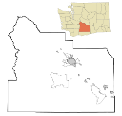 Farron, Washington Location of Farron, Washington  Farron, Washington Farron, Washington (Washington (state)) | |
| Coordinates: 46°24′16″N 120°31′17″W / 46.4045717°N 120.5214519°WCoordinates: 46°24′16″N 120°31′17″W / 46.4045717°N 120.5214519°W[1] | |
| Country | United States |
| State | Washington |
| County | Yakima |
| Elevation[2] | 833 ft (254 m) |
| Time zone | UTC-8 (Pacific (PST)) |
| • Summer (DST) | UTC-7 (PDT) |
| ZIP code | 98951 |
| Area code(s) | 509 |
| GNIS feature ID | 1510964[2] |
Farron is an unincorporated community in Yakima County, Washington, United States, located approximately five miles southwest of Wapato.
The small community developed along the Toppenish, Simcoe and Western Railway Company railway around 1909.[3]
References
- ↑ "Farron". Geographic Names Information System. United States Geological Survey. Retrieved 2012-10-25.
- 1 2 "US Board on Geographic Names". United States Geological Survey. 2007-10-25. Retrieved 2008-01-31.
- ↑ "Station Roster Master List: Farron". Northern Pacific Railway Historical Association. Retrieved October 25, 2012.
Municipalities and communities of Yakima County, Washington, United States | ||
|---|---|---|
| Cities | 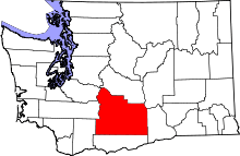 | |
| Towns | ||
| CDPs | ||
| Other unincorporated communities | ||
| Indian reservation | ||
| Footnotes | ‡This populated place also has portions in an adjacent county or counties | |

This article is issued from
Wikipedia.
The text is licensed under Creative Commons - Attribution - Sharealike.
Additional terms may apply for the media files.