Varkala
| Varkala Udaya Marthandapuram [1] | |
|---|---|
| Municipality | |
|
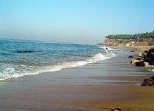
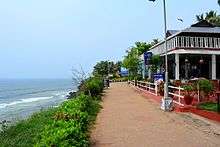
Varkala Beach view from Cliff | |
| Nickname(s): Balita [2] | |
 Varkala  Varkala | |
| Coordinates: 8°43′59″N 76°43′30″E / 8.733°N 76.725°ECoordinates: 8°43′59″N 76°43′30″E / 8.733°N 76.725°E | |
| Country | India |
| State | Kerala |
| District | Trivandrum |
| Named for | Valkalam |
| Talukas | Varkala Taluk |
| Government | |
| • Type | Municipality |
| • Body | Varkala Municipality |
| • Chairperson | Bindu Haridas |
| Area | |
| • Total | 15.42 km2 (5.95 sq mi) |
| Area rank | 3rd largest municipality in Trivandrum |
| Elevation | 190 m (620 ft) |
| Population (2011)[3] | |
| • Total | 40,048 |
| • Density | 2,600/km2 (6,700/sq mi) |
| Languages | |
| • Official | Malayalam, English |
| Time zone | UTC+5:30 (IST) |
| PIN | 695141 |
| Telephone code | 0470 |
| Vehicle registration | KL-16, KL-01 |
| Nearest cities |
Attingal - 15 km Trivandrum - 40 km |
| Lok Sabha constituency | Attingal |
| Website |
www |
Varkala is a municipality and headquarters of Varkala Taluk of Thiruvananthapuram district situated in the Indian state of Kerala. It is located 40 kilometres north-west of Trivandrum (Thiruvananthapuram) which is the capital and largest metropolitan city of Kerala and 15 km north of Attingal municipality.

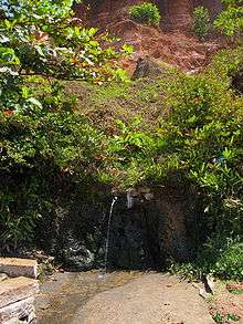
Varkala is the only place in southern Kerala where cliffs are found adjacent to the Arabian Sea.[4] These Cenozoic sedimentary formation cliffs are a unique geological feature on the otherwise flat Kerala coast, and is known among geologists as Varkala Formation and a geological monument as declared by the Geological Survey of India. There are numerous water spouts and spas on the sides of these cliffs. In 2015, Ministry of Mines, Government of India and Geological Survey of India (GSI) have declared Varkala Cliff as a geo-heritage site.[5][6] Varkala is under Varkala police jurisdiction.
Varkala is also famous for the 2,018-year-old Janardana Swami Temple which is an important Vaishnavaite shrine in India and is often referred to as Dakshin Kashi (Benares of the South).[7] The temple is located close to the Papanasam beach, which is considered to have holy waters which wash away sins, and is also an important Ayurveda treatment centre. The temple has an ancient bell removed from a shipwreck, donated by the captain of the Dutch vessel which sank near Varkala without causing any casualties.
Another major landmark in Varkala is the Sivagiri Mutt, established by the social reformer Sree Narayana Guru. The hill-top mausoleum of Sree Narayana Guru is one of the most famous monuments in Kerala state.
History
Legends
It is believed that a Pandyan King was instructed by Lord Brahma to build a temple at this very place to redeem him of his sins. But several other myths abound on the birth of Varkala. Another legend goes like this - when a group of pilgrims approached Sage Narada and told him that they had sinned, Narada threw his valkalam (a loin cloth made from the bark of a tree) and it landed at this scenic village and hence, the place came to be known as Varkala. Narada told the pilgrims to pray for their redemption at Papanasam, which literally means redemption from sins.[8] sree valiyaveetil bhagavathy temple is situating in kurakkanni. The temple is around 600 years old.
Geography
Varkala is located at 8°44′N 76°43′E / 8.73°N 76.71°E.[9]
Geology
Varkala is an important place as far as Kerala Geology is concerned as it exposes sedimentary rocks belonging to the Cenozoic age, popularly known in the Geological literature as the Warkalli formation. Warkalli formation along with Quilon formation represents sediments laid down in the Kerala basin that existed during the Mio-pliocene times. Quilon formation of Miocene age is made up of limestones and the type area is Padappakara near Kollam (Same as Quilon) and the Warkalli formation of Mio-pliocene age (type area is Varkala) is made up of alternating beds of sands and shales exposed along the Varkala cliffs. Thin seams of lignite in the shales of the Warkalli formation suggests good vegetation at the time of deposition of the clayey sediments.
Politics
Varkala assembly constituency is part of Attingal (Lok Sabha constituency), and current MP is Mr. A.Sampath. Current MLA of Varkala Municipality is Mr. Joy V.[10]
Economy
Varkala is a well-known tourist destination. The city has an average-rated water supply system, fire station, several post offices and a police station. The town has government-run medical facilities in addition to over 10 private hospitals and clinics. A government-run nature cure hospital is also near the Papanasam cliff. The District Ayurvedic Hospital is located in Varkala.
Varkala is an important hub for neighbouring places like Attingal, Kadakkavur, Chirayinkeezhu, Kallambalam, Paravur and Kilimanoor.
Demographics
According to the 2011 Census of India,[11] The Varkala Municipality has population of 40,048 of which 18,312 are males while 21,736 are females.
Population of Children with age of 0-6 is 4,479 which is 11.18% of total population of Varkala (M). In Varkala Municipality, Female Sex Ratio is of 1187 against state average of 1084. Moreover, Child Sex Ratio in Varkala is around 981 compared to Kerala state average of 964. Literacy rate of Varkala city is 93.57% lower than state average of 94.00%. In Varkala, Male literacy is around 95.43% while female literacy rate is 92.04%.
The people of Varkala are generally employed in the service sector. A large number of them work outside India, mainly in the Middle East, Singapore, Brunei, Malaysia, the United States and the United Kingdom. Varkala has a ratio of tourists to residents is 1:3.
Transport

- Air
Trivandrum International airport (39 km) is the nearest airport. Varkala Helipad at Varkala Cliff is always ready for receiving helicopters in any time.
- Rail
Varkala Railway Station is well-connected by regular trains from Trivandrum Central and major cities in India like Mumbai, Delhi,Bangalore, Chennai, Hyderabad, Kolkata etc.
- Road
Varkala is at a distance of 9 km from National Highway 66. Private buses and KSRTC buses ply through NH 66 and Varkala. State Highway 64 (Kerala) starts in Varkala and ends in Madathara. The highway is 45 km long.[12]
Tourism
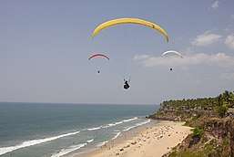
Tourism started thriving by the end of last century at the Varkala beach (Papanasam), which was earlier famous for Vavu Beli, a Hindu custom performed at the beach. Another beach is at Tiruvambadi, one kilometre away and en route the old palace.
There is a helipad close to the beach is the main transport hub and the most convenient way to get in and out of Varkala Cliff and the beach. Arabian Soul, a tropical guesthouse can be found close to the Helipad and is the most convenient place to stay on the cliff due to its close proximity to everything tourists look for yet set back in a tropical garden setting for seclusion and privacy.
Scores of ayurvedic massage parlours line the promenade above the beach.
Hospitals
- District Ayurveda Hospital R-Square Varkala
- Govt. Taluk Hospital, Temple Road, Varkala.
- Govt. Nature Cure Hospital, Helipad.
- Mangala Hospital, Jawaharpark, Varkala
- Sarada Clinic, Nadayara
- SSNMM Hospital, Puthenchantha.
Schools
- Varkala Govt. Model High School
- Little Flower English Medium Higher Secondary School,Edava
- Govt. Lower primary School, Kurakkanni
- Jawahar Public Senior Secondary School,Edava
- Sivagiri Sree Narayana Senior Secondary School,SV.puram,Varkala
- Sivagiri Higher Secondary School,SV.puram
- Palaymakunnu Higher Secondary School,Varkala.
- MRMKHSS, Edava
Colleges
Sightseeing Highlights
Varkala Beach
Varkala Beach or Papanasam beach is a haven for sun-bathing and swimming. It is one of the most popular tourism destination in Kerala. The evening views of the sunset are worth lingering over. The cliff and the beach houses a lot of resorts, restaurants and other shops. The cliff has a long stretch of small shops which goes on for over a kilometer. The black part of the sand on the Varkala Beach contains Thorium-oxide which is a radioactive substance. Thorium and Thorium-oxide and its isotopes are found all over Kerala and can be identified by its black colour.[13]
Cremations
Sections of Varkala Beach (Papanasam Beach) are used by Indians to scatter the ashes of their cremated dead relatives into the sea. Devotees believe that the strong religious properties of the water will extend to the souls of their most recently departed. Despite this burial activity, the sea is popular with swimmers both locals and foreign tourists.
Paravur: Land of Backwaters, Estuaries and Beaches
Paravur is another municipal town with estuary and backwaters, situated 13 km away from Varkala. One could easily enjoy the beauty of this blessed land by travelling on the way towards Pozhikkara, Thekkumbhagam and Kappil. Paravur is in Kollam district, sharing borders with Thiruvananthapuram district. Paravur has an array of backwaters and lakes surrounding the town. But with the advent of roads and others means of transport the inland waterways have been neglected. But renewed efforts are under way to start linking the waterways to an ambitious inland waterways system being sponsored by the state government on the lines of what once existed.
Paravur Lake attracts a good number of tourists. The lake meets the sea and in between a small stretch of road which divides them can be viewed on the way.
Kappil Lake
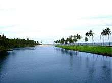
Kappil Lake is about 4 kilometers (2.5 mi) north of Varkala Town. This serene estuary meanders through dense coconut groves before merging into the Arabian Sea. The bridge over the lake is quite a vantage point to view the backwater stretching white and grey to the distant blue horizon. Boating is another great way to browse this tranquil waterway.
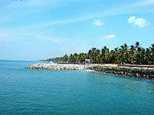
Anjengo Fort
Anjengo Fort is a fort near Varkala. It is a place of historic importance as well as beautiful natural setting, Anjengo is an ideal destination for those who don't mind walking around and explore what is in store. The historic significance tagged to Anjengo comes through foreign powers like the Portuguese, the Dutch and finally the English East India Company. In the year 1684, the English East India Company chose Anjengo to establish their first trade settlement in Kerala. At Anjengo, one can find the remnants of the old English Fort, which was targeted several times by other foreign powers, who were at that time fighting each other to get a firm footing in Kerala. The Fort is now under the protection of National Heritage Monuments. There is also a cemetery inside the fort, which most probably would be having the remains of the occupants of the fort, and the oldest among the burial sites dates to 1704. The beautiful Muthalapuzhi lake is situated in Anjengo.
Varkala Tunnel
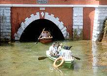
Varkala Tunnel is 151 years old popular tourist highlight. It was a 924 ft long tunnel built in 1867 by Sir T. Madhava Rao the dewan of Travancore, and took 14 years to complete. Varkala Lighthouse is another tourist highlight in the vicinity.
Religious centres
Janardana Swami Temple

.jpg)
Janardana Swami Temple is a very important Vaishnavite shrine and attracts thousands of pilgrims. The temple is about 2000 years old. Facing the temple is the Papasnanam beach where devotees take a bath in the belief that the sacred waters will wash away their sins. A large bell washed up from the wreck of a Dutch merchant vessel is kept on display at the temple.
Sivagiri Mutt
Sivagiri Mutt is a famous ashram in Varkala, founded by the philosopher and social reformer Sree Narayana Guru. Sree Narayana Guru's tomb is also located here. The Samadhi (the final resting place) of the Guru here attracts thousands of devotees every year during the Sivagiri Pilgrimage days 30 December to 1 January. The Sivagiri Mutt, built in 1904, is situated at the top of the Sivagiri hill near Varkala. Even decades after the guru breathed his last here in 1928; his samadhi continues to be thronged by thousands of devotees, donned in yellow attire, from different parts of Kerala and outside every year during the Sivagiri Pilgrimage days - 30 December to 1 January. The Sivagiri Mutt is also the headquarters of the Sree Narayana Dharma Sangham, an organization of his disciples and saints, established by the Guru to propagate his concept of 'One Caste, One Religion, One God'. The Guru Deva Jayanti, the birthday of the Guru, and the samadhi day are celebrated in August and September respectively every year. Colourful processions, debates and seminars, public meetings, cultural shows, community feasts, group wedding and rituals mark the celebrations.
Panayara Triporittakkavu Bhagavathi Temple
Panayara Triporittakkavu Bhagavathi Temple is the one of the most famous Devi temple in Kerala. The Triporittakkavu Temple located in Panayara at Chemmaruthi Grama Panchayath provinces of Varkala (Municipality and Local Assembly); the most famous tourist place in Thiruvananthapuram District. Triporittakkavu Temple was sustain ancientness and heritage up to this era with the deity of Sri. Bhadrakali Devi and the idol was emphasis status of Devi's motherhood, so the deity known as ‘Bhagavathi’. One of the most important statues of the temple was ‘Anakottile’ (elephant fort), it’s constructed with twelve stone pillars in a rectangular shape. The other standing inheritance symbols are 'Kalathattile' (platform for performances) and 'Nalambalam' (The traditional architecture is typically a rectangular structure where four halls are joined together with a central courtyard open to the sky) has construct with ancient carpenter technology known as Thatchu Shastra. These monuments are still breathing to realize the inheritance of Triporittakkavu Bhagavathi Temple The devotees were believed that Triporittakavu Bhagavthi temple constructed earlier than seven hundred years ago. Long time ago in this Bhagavathi Temple had celebrated the festival ‘Kaliyoot’ (Kaliyoot is the dramatic presentation of the genesis of Bhadrakali and Darika the representatives of good and evil respectively)’, once ‘Kaliyoot’ festival celebration was ended with unexpected incident and this circumstance bring to an end of the Kaliyoot festival forever. Meantime this incident (the real battle conducted and ended with bloodshed among the festival) had occurred renaming of the temple as "Triporittakkavu Bhagavathi Temple". This was the real myth alive in these days. Meenabharani festival is the chief festival in Porittakkavu temple, the festival celebrating the month of ‘Meenam’ (March/April) in Malayalam calendar. The Meenabharani festival celebrating ten days and Bharani (Malayalam birth star) was the end day of merriment. These festival days thousands of devotees and believer visiting the temple for worship and blessing. Porittakkavu Temple geographically surrounded by paddy fields and beautiful greenish ambiance and the temple typically allied with harvest. ‘Vrischika Vilakku’ (Traditional event celebrating the month of Vrischikam in Malayalam calendar) celebrating the whole month, this traditional event not only presume that a celebration of Harvest or prosperity of surroundings but all so consider as a procedure of atonement, this was too noticeable in this Occasion . The Goddess Triporittakkavilamma consists of the divine powers showering to the devotees into different occasions for their accomplishment and prosperity. So the devotees believe that the goddess blessing is the only one way to the salvation.
Sarkara Devi Temple
Sarkara Devi Temple is a famous old temple situated near Varkala at Chirayinkeezhu. The temple is famous for the Kaliyoot festival on the Malayalam month of Kumbham (March).
Sree Saraswathy Temple
The Sree Saraswathy Temple, located in Venkulam, Edava, is a VidyaDevi temple famous for Navarathri Sangeetholsavam and Vijayadesami Vidyarambam.
Kaduvayil Juma Masjid
Kaduvayil Juma masjid is situated on NH47 in between Kallambalam and Attingal, is a famous Sunni pilgrimage centre which attracts local Muslims and Hindus.
Climate
Köppen-Geiger climate classification system classifies Varkala's climate as tropical wet and dry . It has heavy rains during June–August due to a southwest monsoon. In summer, the temperature rises to a maximum of 32 °C (90 °F) and 31 °C (88 °F) in the winters. Record high temperature in neighbouring Thiruvananthapuram is 39 °C (102 °F). Annual average rainfall is 3,100 mm (120 in).
| Climate data for Varkala | |||||||||||||
|---|---|---|---|---|---|---|---|---|---|---|---|---|---|
| Month | Jan | Feb | Mar | Apr | May | Jun | Jul | Aug | Sep | Oct | Nov | Dec | Year |
| Average high °C (°F) | 29.9 (85.8) |
30.7 (87.3) |
31.7 (89.1) |
31.8 (89.2) |
31.3 (88.3) |
29.1 (84.4) |
28.6 (83.5) |
28.9 (84) |
29.3 (84.7) |
29.3 (84.7) |
29.1 (84.4) |
29.3 (84.7) |
29.9 (85.8) |
| Daily mean °C (°F) | 26.1 (79) |
26.9 (80.4) |
28.1 (82.6) |
28.6 (83.5) |
28.2 (82.8) |
26.5 (79.7) |
25.9 (78.6) |
26.2 (79.2) |
26.5 (79.7) |
26.5 (79.7) |
26.2 (79.2) |
26 (79) |
26.8 (80.3) |
| Average low °C (°F) | 22.4 (72.3) |
23.2 (73.8) |
24.5 (76.1) |
25.4 (77.7) |
25.2 (77.4) |
23.9 (75) |
23.3 (73.9) |
23.5 (74.3) |
23.7 (74.7) |
23.7 (74.7) |
23.4 (74.1) |
22.7 (72.9) |
23.7 (74.7) |
| Average precipitation mm (inches) | 19 (0.75) |
27 (1.06) |
52 (2.05) |
144 (5.67) |
248 (9.76) |
457 (17.99) |
336 (13.23) |
222 (8.74) |
201 (7.91) |
290 (11.42) |
205 (8.07) |
55 (2.17) |
2,256 (88.82) |
| Average rainy days | 1 | 2 | 3 | 8 | 10 | 19 | 17 | 14 | 11 | 12 | 8 | 3 | 108 |
| Mean daily sunshine hours | 9 | 9 | 8 | 8 | 7 | 5 | 5 | 6 | 6 | 6 | 6 | 7 | 7 |
| Source #1: Climate-Data.org[14] | |||||||||||||
| Source #2: Weather2Travel[15] for sunshine and rainy days | |||||||||||||
References
- ↑ https://www.varkkala.com/pages/history
- ↑ https://www.varkkala.com/pages/history
- ↑ http://www.censusindia.gov.in/pca/SearchDetails.aspx?Id=679313
- ↑ http://www.varkala.info | Details of Varkala
- ↑ "Declaration of Geo-Heritage Sites". pib.nic.in. Retrieved 2016-01-28.
- ↑ "Varkala cliff to be nation's first geopark". The Hindu. 2012-07-07. ISSN 0971-751X. Retrieved 2016-01-28.
- ↑ "Varkala".
- ↑ "Varkala Beach". Kerala Tourism. Retrieved 20 November 2014.
- ↑ Falling Rain Genomics, Inc - Varkala
- ↑ "Assembly Constituencies - Corresponding Districts and Parliamentary Constituencies" (PDF). Kerala. Election Commission of India. Archived from the original (PDF) on 2008-10-30. Retrieved 2008-10-21.
http://www.mpmla.in/mla.php?stcode=S11&pcno=21&acno=230. Missing or empty
|title=(help) - ↑ "Census of India 2011". Retrieved 2015-09-24.
- ↑ "Kerala PWD - State Highways". Kerala State Public Works Department. Archived from the original on 1 December 2010. Retrieved 26 February 2010.
- ↑ "Kerala". Explorra.com. Retrieved 2013-10-20.
- ↑ "Climate: Varkala - Climate graph, Temperature graph, Climate table". Climate-Data.org. Retrieved 27 August 2013.
- ↑ "Varkala Climate and Weather Averages, Kerala". Weather2Travel. Retrieved 27 August 2013.
External links
| Wikimedia Commons has media related to Varkala. |
| Wikivoyage has a travel guide for Varkala. |
District HQ: Thiruvananthapuram | |||||||
| History |  | ||||||
| Geography | |||||||
| Cities and Taluks |
| ||||||
| Transport | |||||||
| Education |
| ||||||
| Buildings | |||||||
| Culture | |||||||
| Lok Sabha constituencies | |||||||
| Sports | |||||||
| Museums | |||||||