Pathanamthitta district
| Pathanamthitta | |
|---|---|
| District | |
 | |
 Pathanamthitta  Pathanamthitta | |
| Coordinates: 9°16′N 76°47′E / 9.27°N 76.78°ECoordinates: 9°16′N 76°47′E / 9.27°N 76.78°E | |
| Country |
|
| State | Kerala |
| Founded by | K. K. Nair[1] |
| Headquarters | Pathanamthitta |
| Area | |
| • Total | 2,642 km2 (1,020 sq mi) |
| Population | |
| • Total | 1,231,577 |
| • Density | 4,675/km2 (12,110/sq mi) |
| Languages | |
| • Official | Malayalam |
| Time zone | UTC+5:30 (IST) |
| ISO 3166 code | IN-KL |
| Vehicle registration |
KL-03 (Pathanamthitta RTO) KL-26 (Adoor SUB RTO) KL-27 (Thiruvalla SUB RTO) KL-28 (Mallapally SUB RTO) KL-62 (Ranny SUB RTO) KL-78 (KonniSUB RTO). |
| Website |
pathanamthitta |
Pathanamthitta District is a district in the southern part of Kerala, India. The district headquarters is in the town of Pathanamthitta. There are four municipalities in Pathanamthitta: Tiruvalla, Adoor, Pathanamthitta and Pandalam.
According to the 2001 Census of India, the population was 1,231,577,[2] making it the third least populous district in Kerala (out of 14), after Wayanad and Idukki.[3] Pathanamthitta has been declared the first polio-free district in India.[4] The district is 10.03% urbanised.[5] Pathanamthitta is one of the richest districts in India with just 1.17% poverty as of 2013, which places the district among top 5 districts in India with least poverty.[6]
Etymology
The district's name is a combination of two Malayalam words, pathanam and thitta, which together mean 'array of houses on the river side'.[7] The district capital is located on the banks of the river Achankovil.
History
It is presumed that the regions that form the district were formerly under the rule of Pandalam, which had connections with the Pandya kingdom.[8] When Pandalam was added to the princely state of Travancore in 1820, the region came under Travancore administration.
The district was formed on 1 November 1982 in the interest of speeding up development. The formation was done by incorporating various portions of the erstwhile Kollam, Alappuzha and Idukki districts. While the taluks Pathanamthitta, Adoor, were taken from Kollam district, Ranni, Konni and Kozhencherry from Idukki district, Pandalam, Thiruvalla and Mallappally were taken from Alappuzha district.[7]Official formation date of Pathanamthitta district-01/11/1982.
Cultural revival
Pathanamthitta being also a land of culture and learning could bring forth the literary talents of two centuries together in single volume named Desathuti: Pathanamthitta Kavithakal. Unnikrishnan Poozhikkad collected 184 poems of different poets of Pathanamthitta starting from 18th century.[9].Although pathanamthitta has a mixture of all religions the Muslim community family has its origin back to the persian turky descendents its roots still sway through the generations.Peerveedu at pathanamthitta is one such family which traces back to history outnumbering the main groups in the proper town this family origin has a long time track road of politicians and leaders.In the 80's late Meera Sahib had built the architectural bridge and helped in the building of the dam that still exists with his great engineering perfection at Mannyaar Dam which still exists as an adventure for many.Throwing over the pros and cons of many inherited families with qualities and heritage of Royal Blood.Meera Sahib was a renowned leader his wife Aysha and 7 children dwelled in the outskirts of the village.This family has the traditional roots that set back to the legends of Hazarat Meerasahib which profounds them to keep there family name in tact
Geography
Pathanamthitta is a landlocked district, located at 9°16′N 76°47′E / 9.27°N 76.78°E, spanning over an area of 2,637 square kilometres (1,018.15 sq mi).[10] The district is bordered by the districts Kottayam and Idukki in the north, Alappuzha in the west, Kollam in the south. To the east it has border with the Tamil Nadu state. Devar Mala is the highest point in Pathnamthitta District.[11]
The district can be divided into three natural geographical regions: the highland, the midland and the lowland. The highland stretches through the Western Ghats, where the hills are tall and covered with thick forests. Western Ghats maintains an average altitude of around 800 m. It descends to the smaller hills of midland in the centre and finally to the lowland. The lowland with its abundance of coconut trees, lies along the eastern borders of Alappuzha district.[12] (western part of Tiruvalla Taluk)
Forest
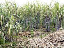
Pathanamthitta district has a reserve forest area of 1,385.27 square kilometres (534.86 sq mi).[2] This is approximately 50% of the total district area. The forest area can broadly be classified as evergreen, semi-evergreen and moist deciduous. The forest is the main source of raw materials for wood based industrial units. Timber is the most important produce.
Rivers
Three important rivers flow through the district. These rivers originate from various mountains of the Western Ghats mountain range. The Pamba (176 km or 109 mi), which is the third longest river in Kerala, has its origin in Pulachimala. The Achankovil river (128 km or 80 mi) originates from Pasukida Mettu, and Manimala river (90 km or 56 mi) originates from the Thattamalai hills. A small portion of Kallada river also falls in the southern border of the district. Pamba and Achankovil rivers together drain more than 70% of the total area of Pathanamthitta.[13][14]
Administration
The district headquarters is at Pathanamthitta town. The district administration is headed by the District Collector. He is assisted by five Deputy Collectors holding charges of general matters, revenue recovery, land acquisition, land reforms and election. Under the three tier system of panchayat in rural areas, Pathanamthitta has one district panchayat, 9 block panchayat and 57 grama panthayats. Under the single tier system in urban areas, there are 4 municipalities the district. In addition, there is a census town (Kozhencherry).
As per the Delimitation of Parliamentary and Assembly Constituencies Order, 2008, Pathanamthitta has five Assembly constituencies, down from eight. However, the district was unified into a single Parliamentary constituency, thus contributing a seat to the Lok Sabha. The Pathanamthitta parliamentary constituency is formed by including all the five Assembly constituencies of the district along with two other Assembly constituencies in the neighboring Kottayam district.[15][16] Congress, Kerala Congress, and the CPM/CPI are the main political parties.
Municipalities: 4
Transport
Trivandrum International Airport (TRV) at Thiruvananthapuram (119 km or 74 mi) is the nearest airport. Aranmula International Airport has been planned at Aranmula, 18 km from Pathanamthitta town. The Rs 2,000 crore airport is the biggest infrastructure project in central Kerala in several decades.[17]
Demographics
According to the 2011 census Pathanamthitta district has a population of 1,195,537,[3] roughly equal to the nation of Timor-Leste[18] or the US state of Rhode Island.[19] This gives it a ranking of 399th in India (out of a total of 640).[3] The district has a population density of 453 inhabitants per square kilometre (1,170/sq mi).[3] Its population growth rate over the decade 2001–2011 was −3.12%.[3] Pathanamthitta has a sex ratio of 1129 females for every 1000 males,[3] and a literacy rate of 96.93%.[3] Pathanamthitta District is one of the few districts to have negative growth in population.
According to the Census of India 2001, the district had a population of 1,234,016 with a density of 467 persons per square kilometre.[20] This is the lowest density in the State after Idukki and Wayanad.[21] Schedule tribes and castes comprise 13% of the total population. The female to male ratio is 1094:1000, which is the highest among the districts in the State.[22] Pathanamthitta's literacy rate is 95%.
Pathanamthitta's major religion are Hinduism, Christianity and Islam. Sikhs, Buddhists and Jains have much smaller followings. As of 2004 the population included 694,560(56.28%) Hindus, 481,602 (39.03%) Christians and 56,457 (4.58%) Muslims, the lowest following in the State.[23]
As of 2011 the population included 681,666(56.93%) Hindus, 456,404 (38.12%) Christians and 55,074(4.60%) Muslims.[24] Among Christians, The Malankara Marthoma Syrian Church and The Malankara Orthodox Syrian Church are the largest groups and together form 96% of the total christian population.
Culture
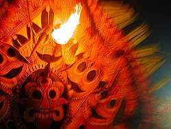
Pathanamthitta district is known for its fairs and festivals. The Padayani is one such major folk art. The colourful art, colloquially known as Padeni, is associated with the festivals of certain temples only in Southern Kerala. The art is a combination of music, dance, painting and satire. Sabarimala, Maramon Convention, Anandapalli and Kadammanitta are some of the major fairs and festivals.[25]
Tourism
With a number of fairs and festivals, Pathanamthitta district is known as the "headquarters of pilgrimage tourism."[26] The district receives an estimated 3 to 4 million pilgrims during the festival season of Sabarimala.[27]
Situated here among the Western Ghats is a temple dedicated to the Hindu deity, Ayyappan. The district is a host to Asia's biggest and the world's second largest Christian convention.[28]
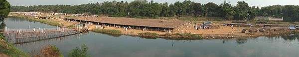
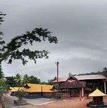
The eight-day Christian gathering in February is held at Maramon on the sand-bed of Pamba River. The three-day Christian gathering is held at Makkamkunnu, Pathanamthitta known as Makkamkunnu Convention by Malankara Orthodox Church. The Cherukolpuzha Hindu convention, Kadammanitta devi temple, the 10th century Kaviyoor mahadeva temple, Parthasarathi temple at Aranmula and anikkattilammakshethram[29] are some of the Hindu religious places of interest.
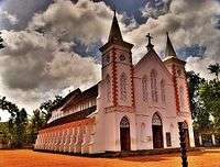
The most important and famous Christian center is Parumala St Peters, St Paul's and St Gregorios Orthodox Church (http://parumalachurch.org) famous for the tomb of Saint Gregorios (Parumala Thirumeni). Millions of Pilgrims visit this church annually.
St. George Orthodox Church, Chandanapally or Chandanapally Valiyapalli is one of the biggest churches in South India, located at a village named Chandanapally, Pathanamthitta District.
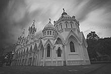
St. George Orthodox Church, Mylapra or Mylapra Valiyapalli or Chakkittayil palli (ചക്കിട്ടേൽ പള്ളി) is one of the famous Georgian pilgrim centre which is very close to Pathanamthitta District headquarters.
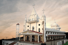
Some of the other Christian places of interest are St. Mary's Orthodox church at Niranam, St. Thomas Ecumenical Church at Nilackal, Manjanikkara Dayara St Stephen's Jacobite Church, Parumala Seminary and St. Mary's Orthodox Cathedral, Thumpamon also known as Thumpamon Valiya Pally, headquarters of Thumapmon Diocese of Malankara Orthodox Church. The churches at Niranam and Nilackal (Chayal) are believed to be among the seven churches founded by St. Thomas the Apostle.[30][31] The Muslim colourful Chandanakkudam festival of the Jama — Al Mosque at Pathanamthitta town attracts many visitors. Although these places are religious in nature, they attract people from all faiths.
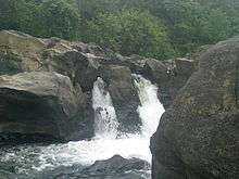
The district is known for its reserve forest and wild life. Perunthenaruvi water falls, Kakki reservoir surrounded by forest and wild animals, dam sites at Moozhyar and Maniyar, elephant training centre at Konni, Charalkunnu hill station are ideal locations for nature enthusiasts. Trekking to the Sabari Hills during January to March is also organized by Pathanamthitta District Tourism Promotion Council (DTPC).
Pathanamthitta district has places known for its historical importance. Among them are, ancient Valiyakoickal Temple and Palace at Pandalam, monument of Velu Thampi Dalawa at Mannadi and the Muloor Smarakom (Muloor memorial). Pandalam was the capital of the ancient Travancore kingdom.
The district has other tourist attractions. Aranmula is a major attraction for its famous metal mirrors and snake boat race. The school of traditional arts attracts foreign visitors. Founded by French artist Louba Schild, the school teaches kathakali, classical dance, classical music as well as kalarippayattu. The palace at Aranmula Aranmula kottaram has a history of 200 years.[32]
Flora and fauna
The forests of the district have excellent wild life habitats. A variety of animals and birds can be found. Tigers, elephants, gaur, deer, monkeys and other wild animals are found in the forest. Giant squirrel, lion-tailed macaques, barking deer and bear can also be spotted in the reserve. Malabar grey hornbill and great Indian hornbill are found. Wide variety of other birds such as sunbirds, woodpeckers and kingfishers can also be seen.
The existence of the wildlife habitat is under threat from various areas. Pollution from fertilizer and industries and illegal sand mining are the major threats. Issues connected to Sabarimala pilgrimage such as clearing of forest land and large amount of waste discharged also threatens the habitat.[13][33]
Sports
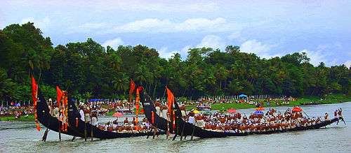
The Aranmula Boat Race is part of a festival celebrated during the month of September. Though the snake boat race is also performed at nearby places, the race held at Aranmula is unique because of the boats' shape and design. Maramadimatsaram (Ox Race) is another such seasonal sport. This is held as part of the largest annual cattle fair of Central Travancore region. The race is held in three categories.[34]
See also
Notes
- ↑ "Pathanamthitta Collectorate opens its walls of art for remembering K.K. Nair the Father of Pathanamthitta District". The Hindu. Retrieved 29 April 2017.
- 1 2 "Census of India". Government of India. Archived from the original on 2007-05-14. Retrieved 2009-08-24.
- 1 2 3 4 5 6 7 "District Census 2011". Census2011.co.in. 2011. Retrieved 2011-09-30.
- ↑ "District profile-Pathanamthitta". Department of Industries and Commerce, Kerala. Retrieved 2009-08-27.
- ↑ "Pathanamthitta". Census of India. Archived from the original on 2010-01-11. Retrieved 2009-08-27.
- ↑ http://www.livemint.com/Politics/FJwyzCLIJU1DrOR00aFmDK/Spatial-poverty-in-kerala.html
- 1 2 "History". Government of India. Archived from the original on 29 July 2009. Retrieved 27 August 2009.
- ↑ "History — Pathanamthitta". Government of Kerala. Retrieved 2009-08-27.
- ↑ Unnikrishnan Poozhikkad, ″Desathuti: Pathanamthitta Kavithakal″, Lens Books, Adoor, 2012
- ↑ "District level database of Pathanamthitta" (PDF). Government of Kerala. 2006. Archived from the original (PDF) on 2008-11-22. Retrieved 2009-08-25.
- ↑ "Pathanamthitta information". Kerala tourism. Retrieved 2009-08-25.
- ↑ "Pathanamthitta- Physiograpy". Government of India. Archived from the original on 29 July 2009. Retrieved 25 August 2009.
- 1 2 "Pampa pollution". Pampa Parirakshana Samithy, N.G.O. Retrieved 2009-08-27.
- ↑ "General features — Kerala". Government of Kerala. Archived from the original on 2 November 2006. Retrieved 27 August 2009.
- ↑ "Parliamentary Constituencies of Kerala - 2008". Government of Kerala. Archived from the original on 3 September 2009. Retrieved 27 August 2009.
- ↑ Radhakrishnan KuttoorKuttoor (2008-01-31). "Due recognition for the youngest district". The Hindu. Retrieved 2009-08-27.
- ↑ "Green tribunal dismisses petition against Aranmula airport". The Times of India. 30 April 2013. Retrieved 2013-04-30.
- ↑ US Directorate of Intelligence. "Country Comparison:Population". Retrieved 2011-10-01.
Timor-Leste 1,177,834 July 2011 est.
- ↑ "2010 Resident Population Data". U. S. Census Bureau. Archived from the original on 2013-10-19. Retrieved 2011-09-30.
Rhode Island 1,052,567
- ↑ "Data sheet — Pathanamthitta" (PDF). Census of India. Retrieved 2009-08-27.
- ↑ "District profile — pathanamthitta" (PDF). Government of Kerala. Archived from the original (PDF) on 25 June 2003. Retrieved 2009-08-27.
- ↑ "Demography — Kerala". Government of India. Retrieved 2009-08-27.
- ↑ Govind, Biju (2004-09-23). "Increase in Muslim population in the State". The Hindu. Retrieved 2009-09-15.
- ↑ "Pathanamthitta District Population Census 2011, Kerala literacy sex ratio and density". census2011.co.in. Retrieved 2017-01-03.
- ↑ "District information — Pathanamthitta". Culture Holidays India Pvt. Ltd. Retrieved 2009-08-27.
- ↑ "Places of Interest". Official website — Pathanamthitta. Archived from the original on 27 September 2009. Retrieved 29 August 2009.
- ↑ "Sabarimala Sri Dharmasastha Temple". Official website — Pathanamthitta. Archived from the original on 18 August 2009. Retrieved 29 August 2009.
- ↑ "Maramon". Department of tourism, Kerala. Retrieved 2010-07-10.
- ↑ "Anikattilamma Temple Mallappally :: Siva Parvathy Temple ::anicadu::pathanamthitta". anikkattilamma.com. Retrieved 2017-01-03.
- ↑ "St Thomas the Apostle of India". St.Thomas Syro Malabar Mission of San Antonio. Archived from the original on 13 September 2010. Retrieved 15 September 2009.
- ↑ "Syro Malabar Church History". St. Thomas Syro-Malabar Church of the Catholic Parish. Archived from the original on 2008-06-04. Retrieved 2009-09-15.
- ↑ "Aranmula". Ministry of Tourism, Government of India. Archived from the original on 2010-05-31. Retrieved 2010-10-07.
- ↑ "TDB to get forest land at Nilackal today". The Hindu. 2005-06-16. Retrieved 2009-08-27.
- ↑ "Maramadimatsaram". Department of tourism, Kerala. Archived from the original on 1 March 2012. Retrieved 27 August 2009.
References
External links
| Wikimedia Commons has media related to Pathanamthitta district. |

- Pathanamthitta district official website
- Pathanamthitta District administration
Places adjacent to Pathanamthitta district | ||||||||||
|---|---|---|---|---|---|---|---|---|---|---|
| ||||||||||