Ottapalam
| Ottapalam | |
|---|---|
| Town | |
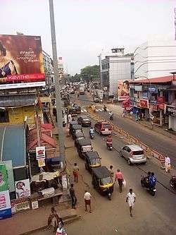 Main Road Ottapalam, near the Bus Stand | |
| Coordinates: 10°46′N 76°23′E / 10.77°N 76.38°ECoordinates: 10°46′N 76°23′E / 10.77°N 76.38°E | |
| Country | India |
| State | Kerala |
| District | Palakkad |
| Lok Sabha constituency | Palakkad |
| Assembly constituency | Ottapalam |
| Government | |
| • Body | Ottapalam Municipality |
| • MP | M. B. Rajesh (CPI(M)) |
| • MLA | P. Unni[1] |
| • Chairman | N.M Narayanan Namboothiri |
| Area | |
| • Total | 32.7 km2 (12.6 sq mi) |
| Elevation | 54 m (177 ft) |
| Population (2011 Census)[2] | |
| • Total | 53,790 |
| • Rank | 2nd in Palakkad district |
| • Density | 1,645/km2 (4,260/sq mi) |
| Languages | |
| • Official | Malayalam |
| Time zone | UTC+5:30 (IST) |
| Pincode | 679 101 |
| Area code(s) | 0466 |
| Vehicle registration | KL-51 |
| Sex ratio | 1000:1121 ♂/♀ |
| Literacy Rate | 91% |
| Website |
www |
Ottapalam is a town in Ottapalam taluk, Palakkad district, Kerala, India.[3]
Chinakathoor Pooram, an event held every year at Chinakkathoor Temple in Palappuram near Ottapalam, is one of the famous festivals in Kerala.[4]
History
Ottapalam was once part of the Valluvanad Swaroopam dynasty.[5]
Valluvanad was a late medieval feudal state in what is now the state of Kerala in South India. The state extended from the Bharathapuzha River in the south to the town of Pandalur in the north during its height in the early Middle Ages. In the west, it was bound by the Arabian Sea at the port Ponnani, while in the east its reach ended at the Attappadi Hills. According to local legends, the last Later Chera ruler gave a vast quantity of land in South Malabar to one of their governors, Valluvakkonithiri, before leaving on a hajj. Valluvakkonithiri was also given the last Later Chera ruler's shield, presumably to defend himself from the sword given to Samoothiri (Zamorin) of Kozhikode, another governor, as a gift from the departing ruler. The Vellatiri rajas were hereditary enemies of the Samoothiri.[5]
Ottapalam is also called as The New Film City of Kerala.[5]
Geography
Ottapalam is located at 10°46′N 76°23′E / 10.77°N 76.38°E.[6] It has an average elevation of 54 metres (177 feet).
Climate
| Climate data for Ottapalam, Kerala | |||||||||||||
|---|---|---|---|---|---|---|---|---|---|---|---|---|---|
| Month | Jan | Feb | Mar | Apr | May | Jun | Jul | Aug | Sep | Oct | Nov | Dec | Year |
| Average high °C (°F) | 32.8 (91) |
34.5 (94.1) |
35.8 (96.4) |
35.1 (95.2) |
33.2 (91.8) |
29.5 (85.1) |
28.6 (83.5) |
29.1 (84.4) |
30.2 (86.4) |
30.8 (87.4) |
31.6 (88.9) |
32.0 (89.6) |
31.9 (89.5) |
| Average low °C (°F) | 22.3 (72.1) |
23.2 (73.8) |
24.8 (76.6) |
25.7 (78.3) |
25.2 (77.4) |
23.6 (74.5) |
22.9 (73.2) |
23.5 (74.3) |
23.5 (74.3) |
23.7 (74.7) |
23.4 (74.1) |
22.4 (72.3) |
23.7 (74.6) |
| Average precipitation mm (inches) | 2 (0.08) |
12 (0.47) |
27 (1.06) |
103 (4.06) |
211 (8.31) |
566 (22.28) |
687 (27.05) |
349 (13.74) |
203 (7.99) |
264 (10.39) |
136 (5.35) |
23 (0.91) |
2,583 (101.69) |
| Source: Climate-Data.org[7] | |||||||||||||
Administration
Ottapalam is sub district of the Palakkad District. Over the last 10 years, the population growth has been 9.2%.The Town is listed in the top 18 most populous Urban Agglomeration In Kerala. The First Defence Park in India will be established in Ottapalam KINFRA industrial park.[8] A film district is also under discussion.
The Ottapalam assembly constituency is part of Palakkad Lok Sabha constituency.[9]
Transport
Road
The Palakkad-Shoranur (Kulappully) State Highway passes through the town.[10] Government buses as well as private bus services operate between Ottapalam and other major towns, such as Thrissur, Palakkad, Mannarkkad, Pattambi, Guruvayoor, Thiruvilwamala, Chelakkara (through the Ottapalam-Mayanur Bridge, inaugurated on 22 January 2011.)[11]
Rail
The town is served by the Ottapalam railway station, which lies between Palakkad and Shoranur Junction on the Jolarpettai–Shoranur line. Seventy-four Indian Railways trains stop at the station.[12]
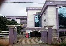
Education
Ottapalam is host to many educational institutes. The GHSS Ottapalam East was established in 1940.[13]
Notable people
The following people were either born in and/or are residents of Ottapalam: Dr K G Raveendran - The most renowned physician and Medical Director & Vice Chairman of The Arya Vaidya Pharmacy ( Coimbatore ) & Research Institute, physician to former President of India and Prime Minister.
- Ottapalam Pappan, Malayalam Drama and Film Actor
- Stephen Devassy, pianist
- Lal Jose, Malayalam film director
- Anil Radhakrishnan Menon, Malayalam film director
- Bhaskar Menon, first Indian to head a multinational corporation, chairman of Lever Brothers (now Unilever)
- K. P. S. Menon, first Foreign Secretary of India. He also served pre-independence India as an Agent-General to China
- M. G. K. Menon, former Union Minister and Scientific Adviser in the Rajiv Gandhi administration
- Lt. General Candeth, was a prominent Lieutenant General in the Indian army
- Shivshankar Menon, 4th National Security Advisor and 26th foreign secretary
- V. P. Menon, seniormost Indian officer in pre-independence British India administration
- M. K. Narayanan, the former chief of the Intelligence Bureau and former National Security Adviser
- K. Sankaran Nair, former director of Research and Analysis Wing and former High Commissioner of India to Singapore
- C. Venkataraman Sundaram, former director of Indira Gandhi Centre for Atomic Research and Padma Bhushan recipient[14]
Notable Places
The following are some important pilgrim centres in Ottapalam :
- Chinakkathoor Temple, Goddess kali
- Kalakkath Bavanam, (House of Kunjan Nambiar)
References
- ↑ "Kerala Assembly Constituencies Election Results 2016-Ottapalam". Elections.in. Retrieved 19 May 2016.
- ↑ http://www.censusindia.gov.in/pca/SearchDetails.aspx?Id=673229
- ↑ "Ottapalam".
- ↑ "Chinakkathoor Pooram". FestivalsOfIndia.com. Retrieved 13 May 2016.
- 1 2 3 princelystatesofindia.com Archived 16 March 2012 at the Wayback Machine.
- ↑ "Maps, Weather, Videos, and Airports for Ottappalam, India". Fallingrain.com. Retrieved 2014-03-05.
- ↑ "CLIMATE: OTTAPPALAM", Climate-Data.org. Web: .
- ↑ The Hindu. "Ottapalam To Have India's First Defence Park". Retrieved 23 July 2016.
- ↑ "Assembly Constituencies – Corresponding Districts and Parliamentary Constituencies" (PDF). Kerala. Election Commission of India. Archived from the original (PDF) on 4 March 2009. Retrieved 19 October 2008.
- ↑ "Kerala State Highways". Kerala PWD Department.
- ↑ "Kerala News : Mayyannur bridge to be opened on Saturday". The Hindu. 20 January 2011. Retrieved 13 September 2011.
- ↑ "Trains to OTP/Ottappalam Station - 54 Arrivals SR/Southern Zone - Railway Enquiry". indiarailinfo.com. Retrieved 27 November 2016.
- ↑ "GHSS Ottapalam East". GHSS Ottapalam East.
- ↑ "Biography" (PDF). Indira Gandhi Centre for Atomic Research. 2018-06-03. Retrieved 2018-06-03.
External links
| Wikimedia Commons has media related to Ottapalam. |
| Wikivoyage has a travel guide for Ottapalam. |