Koyilandy
| Koyilandy Quilandy | |
|---|---|
| Municipality/City/Suburb/Taluk | |
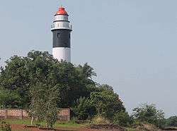 Kadaloor Point Lighthouse, Koyilandy | |
| Coordinates: 11°26′20″N 75°41′42″E / 11.439°N 75.695°ECoordinates: 11°26′20″N 75°41′42″E / 11.439°N 75.695°E | |
| Country |
|
| State | Kerala |
| District | Kozhikode |
| Elevation | 2 m (7 ft) |
| Population (2011)[1] | |
| • Total | 71,873 |
| Languages | |
| • Official | Malayalam, English |
| Time zone | UTC+5:30 (IST) |
| PIN | 673305 |
| Telephone code | 496 |
| ISO 3166 code | IN-KL |
| Vehicle registration | KL 56 |
| Website |
www |
Koyilandy (or Quilandy/Quilandi) is a taluk and a Municipality town in the Kozhikode district in the North Malabar region, state of Kerala. This town is between Kozhikode and Vatakara and is on NH 66 (previously NH 17). It is sometimes identified with Tyndis in Periplus of the Erythraean Sea. The freedom fighter K. Kelappan was born in a nearby village, Muchukunnu.[2]
Geography
Koyilandy is located at 11°26′N 75°42′E / 11.43°N 75.70°E.[3] It has an average elevation of 2 m (6.6 ft).
Demographics
As of 2001 India census,[4] Koyilandy had a population of 68,970. Males constitute 48% of the population and females 52%. Koyilandy has an average literacy rate of 83%, higher than the national average of 59.5%: male literacy is 86%, and female literacy is 80%. In Koyilandy, 10% of the population is under 6 years of age.
Administration
Koyilandy is the thaluk headquarters of 34 villages. They are: Arikkulam, Atholy, Avitanallur, Balussery, Chakkittapara, Changaroth, Chemancheri, Chempanode, Chengottukavu, Cheruvannur, Eravattur, Iringal, Kayanna, Keezhariyur, Koorachundu, Koothali, Kottur, Kozhukkallur, Menhaniam, Meppayur, Moodadi, Naduvannur, Nochad, Palery, Panangad, Panthalayani, Payyoli, Perambra, Sivapuram, Thikkodi, Thurayur, Ulliyeri, Unnikulam, Viyyur and Muchukunnu.
Koyilandy hookahs

Koyilandy hookahs, traditional smoking pipes, of Kozhikode made in Koyilandy were famous across North India, the Gulf and Pakistan. Prepared by Moosari, a coppersmith community, these Hookahs were once considered a pride of Koyilandy. However it is not so any more. But in Gulf countries, Koyilandy hookahs are still very popular as "Malabar Hookah".
The craft owes it origin to a group of Yemeni merchants who had taken up residence at Koyilandy about 500 years ago. They commissioned the local craftsmen to make hookah, an object of oriental culture. Made by local craftsmen, the Hookah impressed Yemeni traders and soon came to be known as Koyilandy Hookah. Besides being ornately designed with attractive motifs, the Koyilandy Hookahs have a coconut shell as the water holder. Even today, these hookahs are exported to gulf countries.
Economy
Economy of Koyilandy revolves around fishing, local businesses and remittance from Gulf.
Transportation

- Railway Station- Koyilandy railway station, established in 1901
- Nearest Airport- Calicut International Airport, approx. 50 km away.
- Road- Koyilandy is only 25 kilometres from Kozhikode city. The road from Kozhikode to Koyilandy passes through Nadakkavu, West Hill, Elathur and Vengalam towns. After Pavangad junction, the road passes through villages like Pookkad, Chemencheri, Poyilkavu, Chengottu kavu and Melur before reaching Koyilandy town. The town of Koyilandy is situated on either side of the busy national highway going to Kannur and Mangalore.
Hospitals

- Koyilandy Taluk Hospital
- Rakesh Hospital
- Co-operative Hospital
- Aswini Hospital Kollam
- Sarada(National) Hospital
- M.M. Hospital
- Sakalya Ayurveda Hospital
- Minhans homeopathy, Multispecialty Clinic
Politics
Koyilandy assembly constituency is part of Vatakara (Lok Sabha constituency).[5]
Places of interest
- Urupunyakavu temple, Moodadi. Temple located at the shore of Arabian sea
- Kollam Parappally Makham (Muslim Dargah) of Thameemul Ansari and the other predecessors of Islamic prophet Muhammad - 2.5 km from Koyilandy Railway Station
- Cheriyamangad Kottayil Shree Durga Bhagavathy Temple
- Pulimuttu (Easy Access to Fishing Boats to Shore)
- Sree kidarathil thalachillon devi temple kanayankode
- Thalachilion Temple Kanayankode
- Valiyakath (Masjid & Dargha Makham) - Beach Road Koyilandy
- Kollam Sree Pisharikavu Temple - Kollam
- Manayadath parambil Sree annapoorneswari Temple - Koyilandy
Peruvannamuzhi Dam
Peruvannamuzhi Dam is situated near Kuttiady. This is an attraction for tourists and students.
Craft Village
An Initiative of Dept of Tourism, Govt of Kerala Sargaalaya, the art & craft village at Iringal is designed as an initiative to put Kerala's traditional arts & crafts on the tourism trail. The craft village is set up on 20 acres of land on the banks of the Moorad River, just 200 meters off Kozhikode – Kannur National Highway near Koyilandy. The craft village has 27 cottages where, a hundred or even more artisans can work. Apart from showcasing crafts & craftsmen from across Kerala, Sargaalaya has a Crafts Design & Technology development centre that provides training for craftsmen on the latest techniques of production & encourages innovation in the traditional system.
Suburbs of Koyilandy
- Vengalam and Thiruvangoor
- Vettilapara and Chemancheri
- Chengottukavu and Melur
- Anakkulam and Moodadi Toll
- Nandi, Thikkody and Payyoli
- Iringal, Payyoli, Thikkodi and Moodadi
- Viyyur, Panthalayani, Chengottukavu and Chemancherry
- Thurayur, Keezhariyur, Arikkulam and Kozhukkallur
- Atholy, Ulliyeri, Balussery and Naduvannur
- Kottur, Avittanallur, Cheruvannur and Meppayur
- Chakkittappara, Chempanode, Perambra and Kayanna
- Koorachundu, Koothaly, Menhaniam and Eravattur
- Nochad, Palery and Changaroth
- MUCHUKUNNU, Koyilothum pady
Road distance
- Payyoly to Meppayur: 11 km
- Payyoly to Perambra. 19 km
- Payyoly to Anchampeedika. 13 km
- thiruvangoor to kappad beach 3 km
- thiruvangoor to adivaram 68 km
- koyilandy to thamarasserry 28 km
- Koyilandy to Muchukunnu 5 km
Educational Organizations
- Thiruvangoor Higher Secondary School, Thiruvangoor
- Govt. Boys Higher Secondary School, Koyilandy
- Govt. Girls HSS, Koyilandy
- Poilkave Higher Secondary School, Poilkave
- Govt. Mopla Vocational Higher Secondary School, Koyilandy
- S.A.R.B.T.M. Govt. College, Muchukunnu
- (R.Sankar Memorial) RSM SNDP College, Koyilandy
- Govt. Industrial Training Institute, Koyilandy
- Ilahiya arts and science college, Chengottukavu
- Sri Sankara Sanskrit university, Nambrathkara, naduvathur(PO)
- Malabar arts and science college, Moodadi
- Gururdeva College Of Advanced Studies
- ICS Secondary School, Koyilandy
Location
See also
References
| Wikimedia Commons has media related to Koyilandy. |
| Wikivoyage has a travel guide for Koyilandy. |
- ↑ http://www.censusindia.gov.in/pca/SearchDetails.aspx?Id=672246
- ↑ http://pressacademy.org/content/kelappan-k
- ↑ Falling Rain Genomics, Inc - Koyilandy
- ↑ "Census of India 2001: Data from the 2001 Census, including cities, villages and towns (Provisional)". Census Commission of India. Archived from the original on 2004-06-16. Retrieved 2008-11-01.
- ↑ "Assembly Constituencies - Corresponding Districts and Parliamentary Constituencies" (PDF). Kerala. Election Commission of India. Archived from the original (PDF) on 2009-03-04. Retrieved 2008-10-19.