Ramanattukara
| Ramanattukara | |
|---|---|
| Municipality/suburb/city/town | |
 Homeo Road, Ramanattukara | |
| Coordinates: 11°11′19″N 75°51′28″E / 11.1886744°N 75.8576775°ECoordinates: 11°11′19″N 75°51′28″E / 11.1886744°N 75.8576775°E | |
| Country |
|
| State | Kerala |
| District | Kozhikode |
| Population (2001) | |
| • Total | 30,436 |
| Languages | |
| • Official | Malayalam, English |
| Time zone | UTC+5:30 (IST) |
| Vehicle registration | KL 81 |
Ramanattukara is a Municipality census town in Kozhikode district in the Indian state of Kerala. This town was formerly called Kadungan Chira village.
website: RamanattukaraNOW
Demographics
As of 2001 India census,[1] Ramanattukara had a population of 30,436. Males constitute 49% of the population and females 51%. Ramanattukara has an average literacy rate of 83%, higher than the national average of 59.5%: male literacy is 85%, and female literacy is 80%. In Ramanattukara, 12% of the population is under 6 years of age.
Etymology
The name came from "Raman anda kara" the place where rama stepped. Then the old name of the place is "Kadungen chira"
Location
Ramanattukara is situated 16 km south of Calicut city. Its location on the intersection of National Highway 17 and National Highway 213 had already given its economy a boost. This town also benefited when the Calicut International Airport came up, as this town is located on the Airport Road. To top it up, now the NH bypass for Calicut city starts from here.
Transportation
The nearest railhead to Ramanattukara is Feroke (5 km) and the nearest airport is Calicut International Airport (10 km).
Economy
This town acts as a commercial center for the nearby smaller villages and towns. As is the case with any other Indian city, Calicut is also experiencing rapid growth. And the city limits have expanded almost up to Ramanattukara now. So new-age buildings for malls, hotels, restaurants are becoming a common sight here. The distance in between Ramanattukara and Vazhayoor is 8 km.
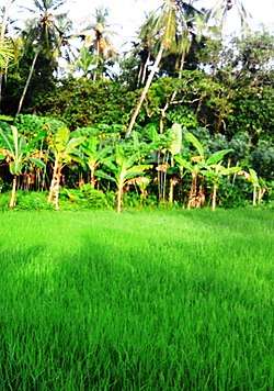
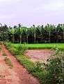
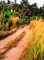
Homeo Road
Homeo Road and Krishi Bhavan Road are two parallel roads originating from Ramanattukara bus station. Both these mud roads attract many joggers in the mornings and evenings as they are flanked by green paddy fields, banana groves and coconut plantations.
.jpg)
Suburbs of Ramanattukara
- Perumugham and Pullikkadavu
- Chelembra, Puthukode, Irumooliparamba and Karad
- Kottupadam, Kakkov, Channayilpalliyali and Akode
- Virippad, Oorkkadavu and Korappadam
- Mundumuzhi, Vazhakkad and Valillappuzha
- Chelari, Kuriyadam and Aikarappady
- Arulippuram, Vaidyarangadi and Pulikkal
- Adivaram, Kuttoolangadi and Koshavarangadi
- EranhikkalRoad, KrishiBhavan, Muttumkunnu and Kokkivalavu
- Kunnampallynagar, Madamthodi and Shanthinagar
- ManthriRoad, HomeoRoad, Poovannurpally and Ette-nalu
- Manthrammal road
Ayikkarappadi
Ayikkarappadi is the eastern part of Ramanattukara on the Manjeri Road. Padinonnam Mile, Kaithakkunda, and Kuriyodam are part of this area.
See also
References
- ↑ "Census of India 2001: Data from the 2001 Census, including cities, villages and towns (Provisional)". Census Commission of India. Archived from the original on 2004-06-16. Retrieved 2008-11-01.
Location
Areas Of Ramanattukara | ||||||||||
|---|---|---|---|---|---|---|---|---|---|---|
| ||||||||||
External links
| Wikimedia Commons has media related to Ramanattukara. |
